
Late-season atmospheric river to impact Washington, Oregon with heavy rains

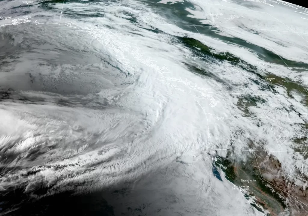
Image credit: NOAA/GOES-West, RAMMB/CIRA, The Watchers. Acquired at 14:30 UTC on June 2, 2024
A late-season atmospheric river event is set to bring heavy rain and strong winds to the Pacific Northwest starting Sunday, June 2, 2024. The weather system is expected to impact several regions, including the Cascades and the Seattle metro area, with potential flooding and significant rainfall.
An atmospheric river event is forecasted to begin on June 2, 2024, bringing significant weather changes to the Pacific Northwest. The National Weather Service (NWS) has issued warnings for strong winds and moderate to heavy rainfall, which are expected to last through early next week.
This weather event will transport tropical Pacific moisture into the region, raising concerns for excessive rainfall, particularly over the favorable terrains of the Cascades, Bitterroots, and Salmon River Mountains, as well as the Seattle metro area.
The NWS’s short-range forecast, released on June 2, 2024, highlights a deep upper low that will facilitate the transport of this moisture.
Excessive rainfall risks are notably high, with a slight risk (at least 15%) in effect through Monday. On Monday, there is also a marginal risk for excessive rainfall and severe thunderstorms over parts of the Southern and Central Plains and the Mississippi Valley. The Northwest is expected to experience cloudy and cooler conditions due to the atmospheric river event, while the Great Plains and Northeast will likely see above-average temperatures this week. Additionally, abnormal heat is projected to expand across parts of the West mid-week.
The Center for Western Weather and Water Extremes (CW3E) provided further details in a post on May 31. According to CW3E, there is a near 100% probability of landfalling atmospheric river activity over the Pacific Northwest and Northern California starting on June 2 and continuing through early next week. This atmospheric river family is forecast to develop in the Central Pacific and progress towards the US West Coast, bringing high levels of integrated water vapor (40+ mm).
The Global Ensemble Forecast System (GEFS) predicts AR 3 – 4 conditions over coastal Oregon and AR 2 – 3 conditions over coastal Washington and Northern California.
“A climatology of atmospheric rivers (1959 – 2023) indicates there are typically 1 – 2 landfalling atmospheric rivers per year during June in central Oregon (45°N, 124°W),” CW3E climatologists said. “Should the forecast AR4 verify, it would be only the fifth AR4+ at this location since 1959.”

The Weather Prediction Center (WPC) forecasts 50 – 127 mm (2 – 5 inches) of precipitation over the Olympic Peninsula, Washington, Oregon coasts, and Cascades for the 72-hour period ending on June 5. Marginal flood risks have been issued for western Washington and portions of western Oregon for the 24-hour periods ending on June 3 and June 4.
The greatest hydrologic impacts are expected on the western side of the Washington Cascades. The Northwest River Forecast Center (NWRFC) is currently forecasting one station above minor flood stage along the Snoqualmie and eight stations above action/bankfull stage, all in Washington, due to the precipitation forecast with this event.
Given that freezing levels are expected to remain elevated, it is likely that all the precipitation associated with the atmospheric river will fall as rain, increasing the risk of flooding due to greater runoff.
As this event unfolds, residents in the affected areas are advised to stay updated with official NWS forecasts, watches, and warnings and take necessary precautions to mitigate the impacts of the severe weather conditions expected over the next few days.
References:
1 Latest Update on Strong AR Forecast Over Pacific Northwest – CW3E – May 31, 2024
2 Short Range Forecast Discussion – NWS/WPC – June 2, 2024

Teo Blašković founded The Watchers in 2011 and edited it until 2026, covering seismic and volcanic activity, extreme weather, space weather and near-Earth objects. Articles on this page are his archive.
Earlier reporting
Nothing on Watchers was published in the last 24 hours. These are older articles.
- 2 atmospheric rivers to bring heavy Sierra snow and California flood risk
- Florida's east coast faces a moderate flash flood risk Wednesday through Friday, with 4 to 8 inches of rain forecast and the St. Johns River near Cocoa already in major flood at 17.13 feet
- El Niño floods kill 2 in Guayaquil as 172.8 mm of rain swamps Milagro, Ecuador's toll rises to 14
- Southern Thailand braces for heavy rain, 15 provinces on flood and landslide alert for November 18-22
