
San Francisco exceeds seasonal rain totals, another atmospheric river and extremely dangerous winds approaching California, U.S.
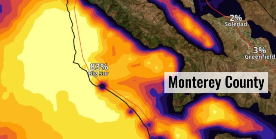
Image credit: NWS
Severe storms swept through California on Thursday, February 1, 2024, causing widespread flooding, power outages, and fallen trees. The first of two storms, part of strong atmospheric river systems, hit the San Francisco Bay Area before moving south towards Los Angeles, delivering over 100 mm (4 inches) of rain in some areas. Officials warn of a “significant threat” from an even larger storm expected over the weekend, with the potential for excessive rain, heavy snow, and strong winds across the state through Tuesday, February 7.
The severe weather affecting California began with a fast-moving storm on Thursday, February 1, 2024, that brought heavy rain and gusty winds, particularly impacting the San Francisco Bay Area before proceeding southward.
The Marin Headlands and coastal mounts north of the Bay Area received more than 100 mm (4 inches) of rainfall, while San Francisco itself saw 60 mm (2.35 inches) of rain, pushing the city’s seasonal totals above average.
This wet weather led to submerged streets, traffic hazards, and the suspension of San Francisco’s cable car services as a precaution. The northern city of Eureka in Humboldt County experienced coastal flooding, recording more than 50 mm (2 inches) of rainfall, a daily record, alongside scattered power outages.
As the storm system advanced towards southern California, it brought flash flooding to areas like southern Los Angeles County and Seal Beach, with reports of cars submerged under water and freeway closures.
The Orange County Fire Authority conducted several rescues due to the storm, including a dramatic rescue from a storm channel in Costa Mesa and a man stranded on an island in the Santa Ana riverbed. The weather also affected higher elevations, bringing 300 – 360 mm (12 – 14 inches) of snow to the Mammoth Mountain ski resort in the Sierra Nevada, a crucial development for the state’s snowpack.
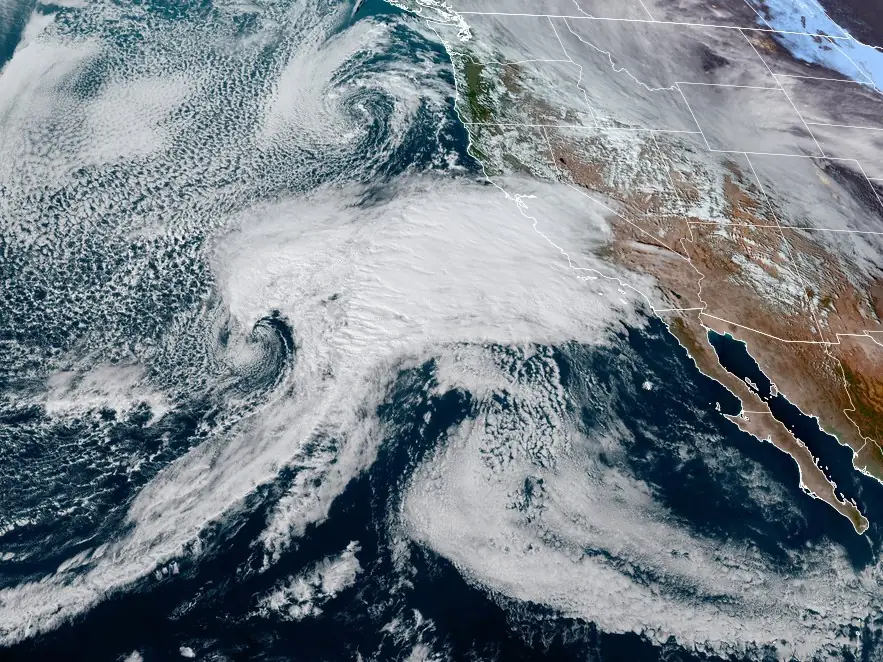
The National Weather Service (NWS) has issued warnings of an even more powerful storm arriving on Sunday, February 4, expected to bring excessive rain, flooding threats, heavy mountain snow, and strong winds across California until Tuesday, February 7.
Additionally, a brief tornado and waterspouts are possible along the central California coast Sunday.
Here are the latest Key Messages for the impending Atmospheric River set to deliver copious amounts of rain & snow to California & parts of Nevada through Tuesday. A High Risk has been issued for Sunday across portions of the Transverse Ranges in Southern California. #CAwx #NVwx pic.twitter.com/smXRh5YW1K
— NWS Weather Prediction Center (@NWSWPC) February 3, 2024
Growing potential for Brief Tornadoes, Waterspouts, and Damaging Wind Gusts Sunday into Sunday night for coasts, valleys, and coastal waters of Southwest California. See graphic below for details. #LAWeather #cawx #Socal #LArain pic.twitter.com/cIuO6mcQA0
— NWS Los Angeles (@NWSLosAngeles) February 4, 2024
This upcoming storm, part of the “Pineapple Express” atmospheric river, poses a significant risk of flash flooding in Santa Barbara, Ventura, and Los Angeles Counties, with the NWS urging residents to heed emergency management warnings and avoid driving through flooded roadways.
A Slight Risk of Excessive Rainfall (level 2/4) is in effect for portions of the central California coast from the Bay Area down through Big Sur. Conditions worsen on Sunday as the low pressure system arrives along the California coast.
There is a High Risk of Excessive Rainfall (level 4/4) over portions of Santa Barbara, Ventura and Los Angeles counties where the combination of high moisture, instability and lift (cold front) will produce a dangerous Flash Flooding situation.
“It’s strongly recommended that people: heed warnings from emergency management personnel, the local forecast office guidance and avoid driving through flooded roadways, NWS forecaster Kebede said.
Broader Moderate (level 3/4) and Slight Risk areas will encompass most of the central and southern coast as well as upslope areas of the Sierra Nevada and parts of the Central Valley.
This moisture plume will spread east into the Sierra, leading to an extremely impactful heavy snow event over the mountains and actually spilling over into portions of the western Great Basin. Winter Storm Warnings are in effect for the aforementioned areas where 1.2 – 1.8+ m (4 – 6 feet) of snow is probable.
High winds will also be a significant issue with whipping rain in the low elevations and blowing snow likely in the Sierra on Sunday.
The focus for heavy rainfall and scattered thunderstorms shift into southern California Sunday night into Monday, February 5 as the upper low continues to direct energy and moisture into the region beneath a persistently strong jet streak. A Moderate Risk of Excessive Rainfall is in effect for portions of Los Angeles, Orange, San Diego and Riverside Counties where the strong cold front will act as a focus for potential flash flooding.
The waters from the Big Sur Coast to 110 km (70 miles) out have been upgraded to Hurricane Force Wind Warnings for winds 65 – 102 km/h (40 – 64 mph) with gusts up to 150 km/h (92 mph).
DAMAGING wind gusts of 75+ mph are likely for the Santa Lucia Mountains of Monterey County on Sunday. Expect ***Widespread*** tree and power line damage. Exercise extreme caution tomorrow and stay safe! #cawx pic.twitter.com/z5F5R7agis
— NWS Bay Area 🌉 (@NWSBayArea) February 4, 2024
Additionally, rapid rises in main stem rivers are expected with this new system with some rivers now anticipated to reach flood stage as early as Sunday morning (LT). “Please be sure to stay informed and weather aware,” NWS Bay Area office meteorologists said.
⚠ Rapid rises in main stem rivers are expected with this system with some rivers now anticipated to reach flood stage as early as tomorrow morning. Please be sure to stay informed and weather aware tomorrow. #CAwx pic.twitter.com/EKhzZmdY3R
— NWS Bay Area 🌉 (@NWSBayArea) February 4, 2024
References:
1 Short Range Forecast Discussion – NWS Weather Prediction Center College Park MD – 231 PM EST Sat Feb 03 2024
I'm a dedicated researcher, journalist, and editor at The Watchers. With over 20 years of experience in the media industry, I specialize in hard science news, focusing on extreme weather, seismic and volcanic activity, space weather, and astronomy, including near-Earth objects and planetary defense strategies. You can reach me at teo /at/ watchers.news.
Commenting rules and guidelines
We value the thoughts and opinions of our readers and welcome healthy discussions on our website. In order to maintain a respectful and positive community, we ask that all commenters follow these rules.