
Widespread severe thunderstorms across the Plains, U.S.
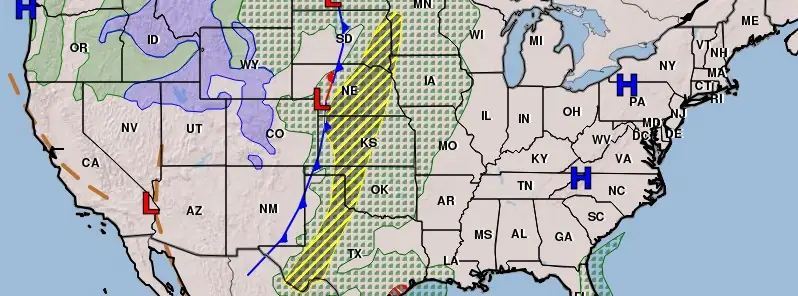
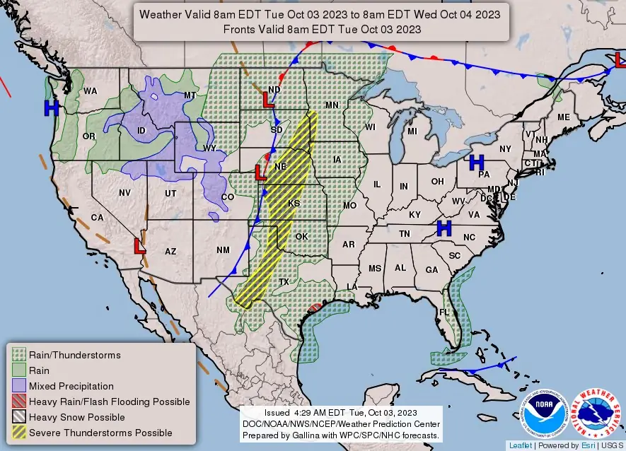
Image credit: NWS
A storm system exiting the West will trigger widespread severe thunderstorms across the Plains on Tuesday. These storms are expected to produce large hail, damaging winds, heavy rain, possible flooding, and a couple of tornadoes across the region. Ahead of this sprawling system, a number of record high temperatures are possible from the Upper Mississippi Valley and Great Lakes into the Northeast.
A front extending from the Northern Plains southward to the Southern High Plains will slowly move eastward to the Upper Great Lakes to the Southern High Plains by Thursday, October 5, 2023. Moisture will pool along the boundary, producing showers and severe thunderstorms over parts of the Plains. As a result, the NWS Storm Prediction Center has issued an Enhanced Risk of severe thunderstorms over parts of the Central/Southern Plains through Wednesday morning, October 4.
The hazards associated with these thunderstorms are frequent lightning, severe thunderstorm wind gusts, hail, and a few tornadoes. Further, there is an increased threat of hail 5 cm (2 inches) or greater over parts of the Central/Southern Plains.
Moreover, moisture streaming onshore over the Western Gulf Coast will produce showers and thunderstorms with heavy rain. Therefore, the Weather Prediction Center (WPC) has issued a Slight Risk of excessive rainfall over parts of the Western Gulf Coast through Wednesday morning.
The associated heavy rain will create mainly localized areas of flash flooding, with urban areas, roads, and small streams the most vulnerable.
The threat of severe thunderstorms will decrease slightly on Wednesday. The front will produce showers and thunderstorms from the Upper Great Lakes southward to the Southern Plains. However, the showers and thunderstorms will become severe over parts of Northwestern Texas and southwestern Oklahoma. Therefore, the SPC has issued a Slight Risk of severe thunderstorms over parts of the Southern High Plains from Wednesday into Thursday morning. The hazards associated with these thunderstorms are frequent lightning, severe thunderstorm wind gusts, hail, and a few tornadoes.
Additionally, on Wednesday, the threat of excessive rainfall will move from the Western Gulf Coast to northeastern Texas, southeastern Oklahoma, southwestern Missouri, Western Arkansas, and extreme northwestern Louisiana. Therefore, the WPC has issued a Slight Risk of excessive rainfall over parts of the Southern Plains and Middle/Lower Mississippi Valley from Wednesday into Thursday morning. The associated heavy rain will create mainly localized areas of flash flooding, with urban areas, roads, and small streams the most vulnerable.
References:
1 Short Range Forecast Discussion – NWS Weather Prediction Center College Park MD – 343 AM EDT Tue Oct 03 2023
I'm a dedicated researcher, journalist, and editor at The Watchers. With over 20 years of experience in the media industry, I specialize in hard science news, focusing on extreme weather, seismic and volcanic activity, space weather, and astronomy, including near-Earth objects and planetary defense strategies. You can reach me at teo /at/ watchers.news.
Commenting rules and guidelines
We value the thoughts and opinions of our readers and welcome healthy discussions on our website. In order to maintain a respectful and positive community, we ask that all commenters follow these rules.