
New storm threat for Vermont in wake of severe historic floods, U.S.
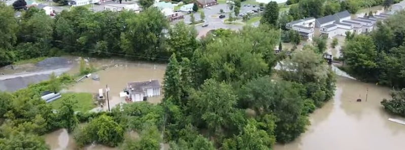
Image credit: State of Vermont – Agency of Agriculture Food and Markets (stillshot)
Just as Vermont starts to recover from its worst flooding in nearly a hundred years, the storm system that triggered tornadoes in Chicago on July 12, 2023, is moving eastward, threatening the region with another deluge. As the state’s residents and officials brace for the impending downpour, there are fears that the additional rainfall will exacerbate the already dire situation.
A series of tornadoes and thunderstorms tore through the greater Chicago area on Wednesday, July 12, 2023, disrupting air travel, damaging homes, and uprooting trees across multiple counties. Of the eight confirmed tornadoes, the most severe impacted Summit, Illinois, a mere 16 km (10 miles) southwest of downtown Chicago, and threatened to move toward the city center.
Air travel was particularly hard-hit by the storms, as turbulent weather conditions led to the grounding of all departures from Chicago O’Hare International Airport and Midway Airport. The Federal Aviation Administration reported over 300 canceled flights in and out of O’Hare and another 32 in and out of Midway, significantly disrupting the daily operations of these major transportation hubs.
Residential areas were also devastated by the storms. In Elgin County, northwest of Chicago, between 20 and 30 homes sustained considerable damage. Similar scenes of destruction were evident in the Cook County town of Countryside, where roofs were blown off and trees uprooted, while the town of La Grange witnessed blown-out car windows.
Now this same system is moving east, placing Vermont and neighboring states once again in the eye of an impending storm.
The rainfall, which reached a record-breaking 228.6 mm (9 inches) on July 10, plunged Vermont into the most severe floods experienced in nearly a century. The torrents led to widespread inundation, submerging roads and towns and instigating an urgent state of emergency.
Montpelier, Vermont’s capital, faced an especially critical situation with the city’s key flood-protection asset, the Wrightsville Dam, reaching its maximum capacity by Tuesday afternoon, July 11. The concern grew over the potential repercussions if the water exceeded the dam’s limit and flowed into the North Branch River. The severity of the situation was unprecedented, as such a scenario had not occurred since the dam’s construction.
It wasn’t until Wednesday, July 12, however, that the city’s anxious population could breathe a sigh of relief. Officials confirmed that water levels at the Wrightsville Dam had started to recede, alleviating immediate fears of further damage.
Recognizing the magnitude of the situation, Vermont Governor Phil Scott is submitting a request to President Biden for a federal disaster declaration, a move aimed at ensuring swift access to federal disaster recovery funding. This action is separate from the emergency declaration already issued by the President.
Yet, the challenges for Vermont are far from over. With the National Weather Service (NWS) forecasting another round of torrential rains for Thursday and Saturday, there is a call for continued vigilance.
The forecast, delivered by NWS forecaster Putnam, points to shortwave energy rotating around an upper-level low over Hudson Bay as a contributing factor for increased lift. This effect, along with a cold front pushing into the Ohio Valley and Northeast, will lead to the renewed development of showers and thunderstorms.
“A Moderate Risk of Excessive Rainfall (level 3/4) has been issued for southern Vermont and adjacent Upstate New York where additional heavy rainfall will pose a rapid increase in the risk for flash flooding following the intense rainfall and flooding earlier this week,” Putnam said.
Simultaneously, there is a high possibility of robust, organized thunderstorms, capable of large hail, damaging winds, and even tornadoes.
With this forecast in view, the people of Vermont are being urged to remain on alert. As Governor Scott aptly put it, “This isn’t over, and it won’t be over after this storm.”
References:
1 Storms target flooded Vermont, Northeast after spawning Chicago tornadoes – Washington Post – July 13, 2023
2 Historic rainfall triggers worst Vermont flood in nearly a century, U.S. – The Watchers – July 12, 2023
3 Multiple tornadoes touch down in northeastern Illinois, disrupting air travel – The Watchers – July 13, 2023
4 Short Range Forecast Discussion NWS Weather Prediction Center College Park MD 333 AM EDT Thu Jul 13 2023
The Watchers team and our contributors bring the latest on extreme weather, earthquakes, volcanic eruptions, space weather, and all things science. We're all about making sense of the natural world and keeping you informed on what’s happening. Got a tip or a question? Hit us up using the form at newstips!
Commenting rules and guidelines
We value the thoughts and opinions of our readers and welcome healthy discussions on our website. In order to maintain a respectful and positive community, we ask that all commenters follow these rules.