Endless onslaught of atmospheric river events in California claim 14 lives, residents urged to be hyper-vigilant

California is once again under threat as an energetic low pressure system quickly gathers strength off the West Coast, bringing with it heavy precipitation, thunderstorms and several feet of snow in the Sierra Nevada region. This, along with already saturated soils and high river levels, is expected to exacerbate ongoing flooding, prolong the risk of flash flooding, and mudslides, especially in recent burn scar regions. The National Weather Service has issued a warning for residents to be prepared, as the heavy rainfall, especially in southern California, is expected to be excessive today and tonight.
- As of January 9, the storms affecting California over the past 10 days have claimed lives of at least 14 people
- Nearly all of California has seen much above average rainfall totals over the past several weeks, with totals 400 – 600% above average values
- An enormous cyclone forming well off the coast of the North American continent will bring yet another Atmospheric River toward the West Coast–this time impacting areas further north from northern California northward up the coast of the Pacific Northwest on Wednesday, January 11
- Officials are urging residents to be hyper-vigilant
Residents of California are bracing themselves for yet another round of heavy precipitation as an energetic low pressure system quickly gathers strength off the West Coast. This rapidly intensifying system is not only highly moisture-laden, but it is also packing thunderstorms. According to National Weather Service forecasters Kong and Oravec, the core of the system will hit the state with moderate to heavy rain resuming across much of California today and continuing through tonight.1
The recent spate of heavy precipitation in California has resulted in nearly saturated soils and increasingly high river levels. Today’s heavy rain will further exacerbate ongoing flooding, prolonging the risk of flash flooding and mudslides, especially across recent burn scar regions. With nearly all of California seeing much above-average rainfall totals over the past several weeks, with totals ranging from 400 – 600% above average, residents are urged to be prepared for the potential dangers.
In addition to the heavy rain, the Sierra Nevada region can expect several feet of snow. This, along with the heavy precipitation, will make travel dangerous in the affected areas. As the storm system pushes rapidly inland later tonight, it will bring widespread mountain snows across the Great Basin.
While the one good aspect of the recent heavy rains has been a relief from the persistent drought that has been plaguing large portions of the West, the recent deluge is now creating a new set of problems. Many of California’s reservoirs are now above their historical average levels, with water levels increasing rapidly during the past month. The National Weather Service advises that widespread considerable flood impact is likely across large portions of California into western Nevada.
Unfortunately, the bad news does not end there, as another atmospheric river is set to impact areas further north from northern California northward up the coast of the Pacific Northwest on Wednesday. When all is said and done, precipitation totals over the next few days will be in the 75 – 178 mm (3 – 7 inches) range through the Transverse Range of southern California, northward along the central to northern California coast ranges and through the Sierra.
As of Monday afternoon, the storms affecting California over the past 10 days have claimed the lives of 14 people – more lives than wildfires in the past two years combined.
“Our message to Californians is simple: be hyper-vigilant,” Governor Newsom said on January 9. “There are still several days of severe winter weather ahead and we need all Californians to be alert and heed the advice of emergency officials. Thanks to the President signing off on our request for emergency declaration, we are mobilizing all available resources at every level of government to protect lives and limit storm damage. Today marks five years since the deadly Montecito mudslides that claimed 23 lives – as Montecito faces evacuations today, it’s a solemn reminder of how quickly conditions can change.”
Recent heavy storms have also led to widespread power outages across the state. This week alone, a large number of customers, over half a million, have experienced loss of power during the storm, with the most affected area being the Sacramento metropolitan region.2
Though the numbers have not reached that scale again, sporadic power outages have remained an ongoing issue. On Monday, over 100 000 residents were without power, and by 12:00 UTC on January 10, that number had risen to 170 000.
A significant portion of the state’s outages on Tuesday occurred in Santa Clara County, which includes San Jose. The power outages are an additional challenge for residents dealing with heavy precipitation, flooding, landslides, and heavy snowfall.
Ventura County was hit particularly hard in the latest storm. As of early Tuesday morning, parts of the county have received over 228 mm (9 inches) of rain, with more expected.
On Monday, January 9, 14 people were rescued from the rising waters of the Ventura River in Ventura, California. The rescue efforts were captured in dramatic footage that showed first responders in the water. Among the 14 people rescued, seven were immediately brought to safety, while the remaining seven were evaluated for rescue.
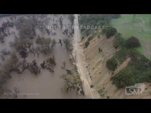
On Monday afternoon, an officer from the California Highway Patrol captured incredible footage of a massive landslide in Fresno County. The video depicts boulders, smaller rocks, mud and debris tumbling down a mountain side near Shaver Lake and impacting on state Route 168 which was covered by the rain. Luckily, no vehicles were in the area and no injuries were reported.
The Browns Valley Road Bridge in Santa Cruz County collapsed as seen in a video shared by CAL FIRE. The video shows one end of the road snapped away from the river bank and falling into the water. CAL FIRE reported that their crews contacted the residents in the area, and the alternate route is Las Colinas Drive.
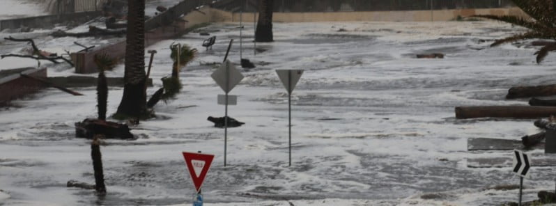
On Monday morning, the San Lorenzo River in Santa Cruz County overflowed creating torrential flooding in the Felton Grove neighborhood and forcing the evacuation of at least 30 homes.
“We’ve never had it this bad,” one of the residents told KTVU. The water was so high in some parts of the neighborhood, it touched the stop signs. First responders could be seen launching jet skis into the flooded roadways to rescue stranded homeowners.
Residents of the Central Sierra Nevada Mountains between Yuba Pass (Hwy 49) and Ebbetts Pass (Hwy 4) including the greater Lake Tahoe area, are warned to be cautious as high avalanche danger is expected to last through Tuesday night. “The winter storm with gale-force winds, high-intensity snowfall, heavy new snow accumulation, and rain on snow will result in widespread avalanche activity in the mountains,” the Sierra Avalanche Center said.
The public is urged to take necessary precautions and avoid traveling in, near or below avalanche terrain, as it could be extremely dangerous. Any steep slope could be hazardous during this time period.
California State Parks officials have announced that a number of state parks will be temporarily closed. As of Monday, 41 parks have been fully closed and 44 more are partially closed until further notice.
In conclusion, at least 14 lives have been lost as powerful atmospheric river events hit California over the past weeks. The state is facing yet another round of heavy precipitation, with moderate to heavy rain expected to resume across much of the state today through tonight. This, along with thunderstorms and heavy mountain snow, will make travel dangerous in the affected areas and exacerbate ongoing flooding while prolonging the risk of flash flooding and mudslides. With another atmospheric river set to impact areas further north on Wednesday, residents are urged to stay informed and take all necessary precautions to protect themselves and their property.
References:
1 Short Range Forecast Discussion NWS Weather Prediction Center College Park MD 300 AM EST Tue Jan 10 2023
2 Tens of thousands remain without power in California on Tuesday – AccuWeather – January 10, 2023
Featured image credit: CHP Santa Cruz


When you keep on electing luciferins to represent you of the likes of Gruwsome Newsome and Jezebel Pelosi, you get what the Creator gives you, enjoy the fruits of your labor.