
At least 5 people killed as deep and fast-moving storm hits Western U.S., extremely active weather pattern continues
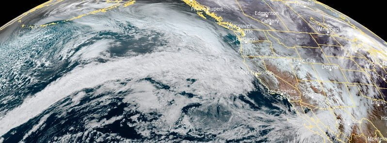
Image credit: NOAA/GOES-West, RAMMB/CIRA, The Watchers. Acquired at 22:20 UTC on December 28, 2022
At least 5 people were killed as a deep and fast-moving storm system brought flooding and landslides to California and Oregon, U.S. over the past couple of days. The event took place just days after a massive winter storm caused severe blizzard conditions and left more than 50 people dead.
- The National Weather Service (NWS) warns Western U.S., especially California, can expect an extremely active weather pattern over the next several days
- A constant flow of moisture will inundate the region with heavy rain, flooding, mountain snow and high winds as a potent storm arrives Friday into Saturday in California
A low-pressure system over the Northeast Pacific and atmospheric river produced widespread short-duration but heavy rainfall in California and Oregon on December 27, at times bringing up to 25 mm (1 inch) of rain per hour.
At least 5 people were killed in car crashes all involving downed trees, Oregon authorities said.
Although this region often experiences atmospheric storms, what made this one unusual is its strength and duration.
As of Wednesday afternoon, December 28, about 75 – 150 mm (3 – 6 inches) of rain was measured in the hardest hit areas and more rain is expected through the end of the week as a series of fronts move onshore the West Coast, track to the West and exit across the Plains spreading moderate to heavy precipitation across the West Coast and for portions of the Deep South.
An initial wave of moisture will make its way inland over the Pacific Northwest and parts of California today, December 29, with a potent atmospheric river following on its heel for the end of the week, NWS forecasters Campbell and Snell noted.1
Moderate to heavy precipitation is expected along with heavy mountain snow.
Most of the potential impacts are anticipated across central/northern California and parts of southwest Oregon where rainfall amounts of 75 – 150 mm (3 – 6 inches) are forecast through early this weekend.
These amounts may lead to scattered instances of flash flooding, especially near recent burn scars where terrain is most susceptible to rapid runoff.
The Weather Prediction Center has identified an area having a Slight Risk (level 2/4) of Excessive Rainfall for these regions in order to further highlight the flash flood threat.
Heavy snow is possible across the higher elevations of the Cascades and Sierra, with storm total snowfall amounts up to several feet possible.
Most of the snow will be confined to the highest terrain as warm Pacific air pushes snow levels very high and generally above pass level.
Moisture will also spread into the Intermountain West along the strong Pacific jet stream, with moderate to heavy snow possible across northern Nevada by Friday night.
“California in general can largely use this precipitation,” said William Churchill, a forecaster and meteorologist with the National Weather Service’s Weather Prediction Center in College Park, Md. “Unfortunately, when too much occurs all at once, it does cause problems.”
The greatest risk, he added, was in previously burned areas along the coast, where rapid, prolonged rainfall could cause mudslides or debris flows.
“Most basins across southeast Oregon and southwest Idaho are running 125%-150% of normal for late December,” meteorologists at the NWS office in Boise said on December 29. “The pattern looks to remain active heading into the first week of January.”
References:
1 Short Range Forecast Discussion – NWS Weather Prediction Center College Park MD – 307 AM EST Thu Dec 29 2022
I'm a dedicated researcher, journalist, and editor at The Watchers. With over 20 years of experience in the media industry, I specialize in hard science news, focusing on extreme weather, seismic and volcanic activity, space weather, and astronomy, including near-Earth objects and planetary defense strategies. You can reach me at teo /at/ watchers.news.
Commenting rules and guidelines
We value the thoughts and opinions of our readers and welcome healthy discussions on our website. In order to maintain a respectful and positive community, we ask that all commenters follow these rules.