
Major winter storm brings heavy snow and damaging ice, travel hazards from Mid-South to the Northeast, U.S.
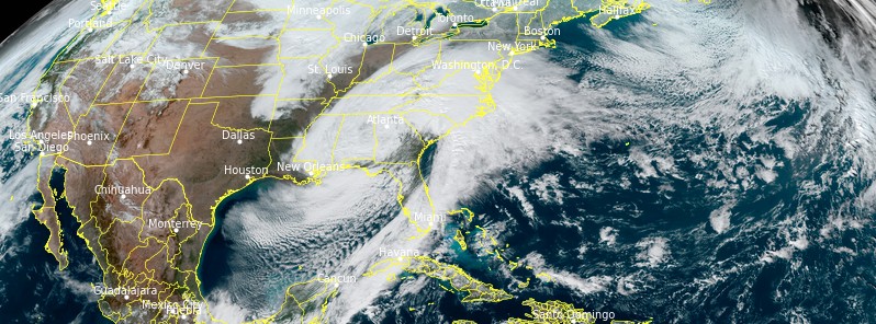
Image credit: NOAA/GOES-16, RAMMB/CIRA, TW. Acquired at 18:20 UTC on January 16, 2022
Heavy snow and ice accumulations are likely to produce hazardous travel, downed trees, and power outages from the Mid-South to the Northeast, U.S. The heaviest snow is expected along and just west of the Appalachians, and the most damaging icing is likely across parts of North Carolina.
Heavy snow will extend from the Tennessee Valley, Central/Southern Appalachians, and parts of the Mid-Atlantic, with significant rain/freezing rain over parts of the Southeast, Central/Southern Appalachians, Mid-Atlantic from Sunday morning to Sunday evening, January 16, 2022, NWS forecaster Ziegenfelder noted.1
From Sunday evening into Monday morning, January 17, heavy snow will extend into parts of the Ohio Valley, Lower Great Lakes, and Northeast. Also, rain/freezing rain will move into parts of the northern Mid-Atlantic and Northeast.
As the major winter storm tracks from the Southeast up the East Coast today, keep track of snow & ice totals plus wind reports using our Local Storm Reports page! Visit the page via the link here: https://t.co/MpUoy7ZqFP pic.twitter.com/wIapcPJDEn
— NWS Weather Prediction Center (@NWSWPC) January 16, 2022
Furthermore, the rain will move into parts of the northern Mid-Atlantic and Southern New England overnight Sunday.
On Monday, as the storm moves across the Northeast, the rain will develop over the coastal regions of Maine with heavy snow inland.
Light snow will linger over parts of the Central/Southern Appalachians into the Northeast by Monday evening into Tuesday.
The heavy snow will end overnight Monday over Maine. The combination of snow and ice may cause hazardous road conditions during and after the storm.
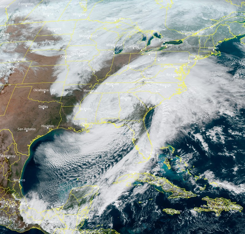
Image credit: NOAA/GOES-16, RAMMB/CIRA, TW. Acquired at 18:20 UTC on January 16, 2022
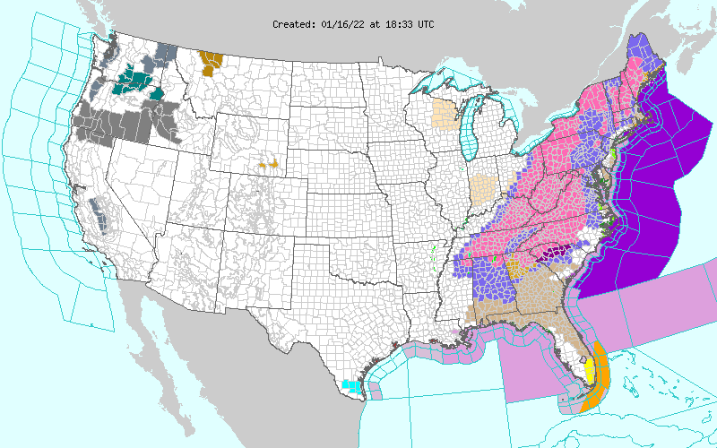
In terms of snow rates, more than 2.5 cm (1 inch) per hour are possible over parts of the Tennessee Valley and along and just west of the Appalachians today and Monday.
Ice accumulations will expand from northeast Georgia through the interior Mid-Atlantic states, with the most damaging icing likely across the Piedmont of the Carolinas, including Charlotte, NC, and Greensboro NC, which will result in dangerous travel, power outages, and tree damage.
This high-impact winter storm over land will bring hazardous marine weather over the Atlantic offshore waters with winds nearing hurricane force to 110 km/h (70 mph), NWS OPC said.
As a follow-up, this system is expected to produce seas near 9 m (30 feet) per the OPC forecast.
As a follow up, this system is expected to produce seas near 30 ft per the OPC forecast, which is animated below. pic.twitter.com/1BW6x9Qhtd
— NWS OPC (@NWSOPC) January 16, 2022
A few different GOES-E satellite views of the intensifying low pressure across the SE this morning. The forecast is still on track, with widespread #storm warnings (dark purple on the warnings map) spanning all 18 offshore zones. #MarineWx pic.twitter.com/cYqwP8uyl5
— NWS OPC (@NWSOPC) January 16, 2022
References:
1 Short Range Forecast Discussion – NWS Weather Prediction Center College Park MD – 249 AM EST Sun Jan 16 2022
I'm a dedicated researcher, journalist, and editor at The Watchers. With over 20 years of experience in the media industry, I specialize in hard science news, focusing on extreme weather, seismic and volcanic activity, space weather, and astronomy, including near-Earth objects and planetary defense strategies. You can reach me at teo /at/ watchers.news.
Commenting rules and guidelines
We value the thoughts and opinions of our readers and welcome healthy discussions on our website. In order to maintain a respectful and positive community, we ask that all commenters follow these rules.