
New South Wales hit by strong winds and worst flood in 29 years, Australia
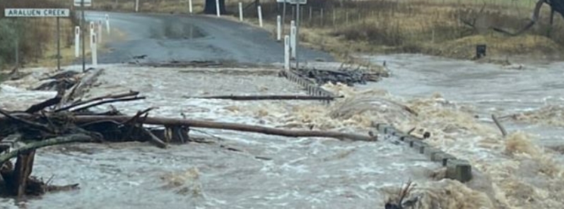
Image credit: BOM
Torrential rain and strong winds lashed the New South Wales South Coast over the weekend, causing the worst flooding in the area for 29 years. High waves killed a 44-year-old surfer in Sydney's Collaroy. At least 1 600 emergency calls had also been made during the day, while 2 000 customers were left without power.
Heavy rains caused flooding and prompted three evacuation orders on the South Coast. Damaging winds with gusts of more than 90 km/h (55 mph) hit the Sydney and Illawarra coast.
Winds reached 93 km/h (58 mph) at Norah Head on the Central Coast. Waves peaked at over 5 m (16 feet) in Sydney, and much of the coastline was under a warning for hazardous surf and severe weather– from Ulladulla to Port Macquarie.
Amid the wild weather, a 44-year-old surfer was pulled unconscious at Collaroy Beach. The victim later died in Royal North Shore Hospital.
In Wamberal, residents have been on high alert after weeks of extreme weather caused major coastal erosion, posing threats to nearby homes.
Across NSW, the State Emergency Service (SES) received 1 600 calls for help due to downed trees, flooded roads and homes, and damaged properties. About 400 of those were in Sydney and the Blue Mountains.
The Bureau of Meteorology (BOM) issued a flood warning just before midday on Monday, August 10 as the Shoalhaven River peaked at 4.13 m (13.5 feet) at Nowra.
BOM noted that the area is experiencing its worst flooding since June 1991. Some 40 flood rescues were conducted across the state.
An SES spokesperson said much of the calls were from Berry, Nowra, Broughton Vale, and Gerringong.
"We will issue an all-clear when it is safe for people to return home," said SES commissioner Carlene York.
"It's fast-flowing, so there's lots of refuse and tree material coming down in that (Shoalhaven) river so it's quite dangerous."
About 2 000 customers of Endeavour Energy remained without electricity on Monday afternoon as the storm created 270 electrical hazards due to fallen branches and trees.
The low responsible for the extreme weather is forecast to persist, bringing the most intense conditions to the southeast.
Showers are expected in the south until Thursday, August 13.
Commenting rules and guidelines
We value the thoughts and opinions of our readers and welcome healthy discussions on our website. In order to maintain a respectful and positive community, we ask that all commenters follow these rules.