
Powerful derecho wreaks havoc across the Midwest – one of the worst weather events of 2020 in the U.S.
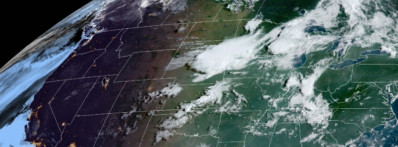
Image credit: NOAA/GOES-East, RAMMB/CIRA. Acquired 13:10 UTC on August 10.
A rare derecho — severe storm with hurricane-force winds — ripped through the Midwest on Monday, August 10, 2020, leaving almost 1.5 million customers without power, toppling numerous trees and vehicles, and causing major, widespread property damage across several states. Northern Illinois University meteorology professor Victor Gensini described the event as one of the worst weather events of 2020 for the U.S.
The storm tore through a straight-line path, hence the name derecho, across eastern Nebraska, Iowa, Wisconsin, and Illinois.
It lasted for several hours and likely caused more extensive damage than a usual tornado, according to Patrick Marsh, science support chief at the National Weather Service (NWS) Storm Prediction Center (SPC).
Widespread damage was reported south of the U.S. Highway 20 south to around Interstate 80 in Iowa. Several vehicles were flipped over, trees were downed, and communication services were interrupted to the point where the entire Fayette County lost connection.
Marsh pointed out that a derecho is not considered a hurricane as it has no eye and its winds come across in a line, but the damage it inflicts is spread over such a massive area that it is more like an inland hurricane than a more powerful tornado.
In northern Illinois, NWS recorded a wind gust of 148 km/h (92 mph) near Dixon as the storm toppled trees and power lines. Roadways were blocked in Chicago and its suburbs as a result.
Professor Gensini said the derecho may go down as one of the strongest ones in recent history, also describing the event as one of the worst severe weather events of 2020 for the country.
Slower, higher resolution view over the last 30 minutes. pic.twitter.com/60t8Md4ez5
— Dakota Smith (@weatherdak) August 10, 2020
Estimating 70 MPH gusts on Hwy 47 just north of Morris, IL at 3:25 PM CT #ilwx @NWSChicago pic.twitter.com/A5KY1jmjZK
— Andrew Pritchard (@skydrama) August 10, 2020
Storms are now over much of Chicago. WILD time lapse video from Willis Tower shows what it looked like as the system moved in. LIVE UPDATES: https://t.co/uJmORJPm4i pic.twitter.com/UR7rx5kkYn
— NBC Chicago (@nbcchicago) August 10, 2020
Very impressive burst of winds blew through the north side of #Chicago just north of Wrigley Field just after 4:00 PM. Peak winds likely hit 70 mph as numerous small and medium-sized trees were snapped. pic.twitter.com/F2CCOBEjzO
— Steve Bowen (@SteveBowenWx) August 10, 2020
As the storm left the city, it became more powerful as it swept through north-central Indiana. In central Iowa, winds of up to 161 km/h (100 mph) injured several people and damaged numerous properties in Marshall County.
"We had quite a few people trapped in buildings and cars," said homeland security coordinator Kim Elder, adding that the extent of injuries is unknown but no casualties were reported.
"We’re in a life-saving mode right now," Elder stated. Dozens of cars at one factory had windshields blown out. Some buildings were also caught on fire.
Marshalltown mayor Joel Greer declared a civil emergency. As of 20:00 UTC (15:00 LT), almost 450 000 customers lost power supply. In the Des Moines area, nearly 101 000 were left without electricity.
Damage to buildings was reported in areas including Cedar Rapids, Iowa City, and Des Moines. Winds also tore the roof off a hockey area in Urbandale. In Lisbon, a newly-built press box was blown away.
WOW. Found this video on TikTok from Iowa this morning. Easily 90-100mph downbursts. Incredible how those healthy trees managed to stay in one piece after being man-handled. credit to “busyiowagirl2” on TikTok. #derecho #iawx pic.twitter.com/bKO5VczwnE
— Landon (@SwagChicagoWx) August 11, 2020
Insane footage from the derecho moving through eastern Iowa this morning. This is from Belle Plaine, Iowa which is east of Des Moines but west of Cedar Rapids. #IAwx pic.twitter.com/nKdfonpveC
— Tyler Roney (@TylerJRoney) August 10, 2020
@NWSDesMoines this is behind our house in Huxley. Straight line wind or tornado?? Lost most of our tree in the yard. Part of tree did punch a hole in wall of house and hole in roof pic.twitter.com/t5u3u2pjXv
— Steve Pietsch (@PietschSteve) August 11, 2020
Stunning panoramic view of this morning’s shelf cloud in Sioux City, Iowa.
Since this photo was taken, the derecho has traveled well over 400 miles producing wind gusts exceeding 110mph!
Photo sent in by: Andrew Storm#weather #derecho #stormhour #iawx pic.twitter.com/RxqW9nN4lD
— Nash from Nashville (@NashWX) August 10, 2020
"There's a lot of tree damage. Very high winds. It will be a significant effort to get through it all and get everybody back on," said MidAmerican spokeswoman Tina Hoffman. "It was a big front that went all the way through the state."
Public safety spokesman Greg Buelow said Cedar Rapids had "both significant and widespread damage throughout the city." He added, "We have damage to homes and businesses, including siding and roofs damaged. Trees and power lines are down throughout the entire city."
By Monday evening, almost 1.5 million customers were without electricity in the wake of the storms– from eastern Nebraska through Indiana.
SPC has issued a Moderate Risk for severe thunderstorms for parts of the Midwest. The ongoing derecho is forecast to continue Tuesday afternoon, August 11.
"Expect strong to severe storms to continue farther east into lower Michigan and Indiana, while extending south into central Illinois this evening before dissipating overnight," NWS said.
The crop damage to corn has been massive. The next day corn future spiked. It seems like everywhere we’re losing food, 1% here, 2% there, 1% over there.
In 2021 Child hood obesity will be a fond memory.