
Tropical Storm “Amanda” hits Guatemala and El Salvador, leaving at least 11 people dead — very heavy rain falling across Central America
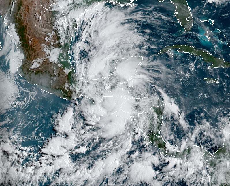
Featured image: Amanda at 13:40 UTC on May 31, 2020. Credit: NOAA/GOES-16, RAMMB/CIRA
Tropical Storm "Amanda" formed at 09:00 UTC on May 31, 2020, as the first named storm of the 2020 Pacific hurricane season. At the time, the storm was about 90 km (55 miles) south of Guatemala City, Guatemala. Just three hours later, Amanda made landfall in southeastern Guatemala with maximum sustained winds of 65 km/h (40 mph) and very heavy rainfall. The storm caused significant damage along coastal cities of Guatemala and El Salvador, causing rivers to overflow and sweeping away buildings. At least 11 people have been killed in El Salvador, as of 20:00 UTC on May 31.
Amanda weakened into a depression after it made landfall, but its remnants may rotate around the larger circulation of the Central American Gyre and move out over the water in the Bay of Campeche.
There is a medium possibility that the remnant circulation of Amanda may develop into a tropical cyclone in the SW Gulf when it emerges over water, NHC forecasters said.

Amanda at 13:40 UTC on May 31, 2020. Credit: NOAA/GOES-16, RAMMB/CIRA
The storm has already caused significant damage along coastal cities of Guatemala and El Salvador, causing rivers to overflow and sweeping away buildings.
Severe flooding in El Salvador left at least 11 people dead and one missing. The country's Minister of the Interior reported on Sunday morning that Red Alert was activated throughout the country. President Nayib Bukele declared a 15-day national state of emergency due to devastation caused by the storm.
Amanda dissipated by 21:00 UTC about 165 km (100 miles) NNE of Guatemala City. The remnants are moving toward the north near 20 km/h (13 mph) and are forecast to turn NE and move over eastern Mexico on Monday and be near the southern Bay of Campeche late Monday and Tuesday (CDT).
Through the middle of the week, Amanda's remnants are expected to produce total rain accumulations of 250 to 380 mm (10 to 15 inches) over El Salvador, southern Guatemala, western Honduras, and the Mexican states of Tabasco and Veracruz.
This system is also expected to produce 125 to 250 mm (5 to 10 inches) of rain over northwestern Nicaragua, Belize, and the Mexican states of Quintana Roo, Campeche, Chiapas, and Oaxaca.
Isolated maximum amounts of 500 to 635 mm (20 – 25 inches) are possible in El Salvador, southern Guatemala, Tabasco, and Veracruz.
This rainfall may produce life-threatening flash floods and mudslides.
A Central American Gyre is over the eastern North Pacific, with the broad cyclonic circulation around the gyre encompassing the discussion waters N of the equator and E of 98W, including portions of southern Mexico and Central America, NHC forecasters said.
Moderate to strong winds are noted across much of these waters, with seas in the 1.8 – 3 m (6-10 feet) range. Numerous moderate and scattered strong convection is noted across much of these waters, particularly N of 10N between 87W and 94W.
Areas of thunderstorms are impacting portions of Central America from Nicaragua northwestward to Southern Mexico and the Gulf of Tehuantepec.
The gyre will move slowly northward, gradually encompassing much of Central America and southern Mexico within the next 24 hours.
Winds around the gyre will continue to advect abundant moisture into portions of Central America and southeastern Mexico for the next several days. This will create a dangerous situation for these areas with an extended period of active and wet weather, and periods of heavy rainfall, through the weekend and into next week, especially over southern Guatemala, El Salvador, southern Honduras, western Nicaragua, and portions of southern Mexico E of Veracruz and eastern Oaxaca.
This will bring the potential for life-threatening flash floods and mudslides for locations that receive the heaviest rainfall, especially in areas of mountainous terrain.
I'm a dedicated researcher, journalist, and editor at The Watchers. With over 20 years of experience in the media industry, I specialize in hard science news, focusing on extreme weather, seismic and volcanic activity, space weather, and astronomy, including near-Earth objects and planetary defense strategies. You can reach me at teo /at/ watchers.news.
Commenting rules and guidelines
We value the thoughts and opinions of our readers and welcome healthy discussions on our website. In order to maintain a respectful and positive community, we ask that all commenters follow these rules.