
Severe storms hit Iraq, two large tornadoes touch down in Mosul

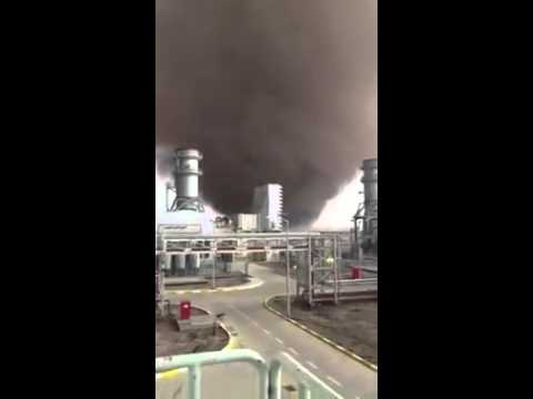
Image credit: Tornado near Mosul, Iraq on April 3, 2019
Severe storms have been affecting multiple governorates of Iraq since March 23, 2019. On April 3, two large tornadoes reportedly formed west of Mosul after a storm swept through the region.
The storms were recorded in multiple governorates, including Anbar, Basra, Dahuk, Diyala, Kirkuk, Missan, Muthanna, Ninewa, Salah al-Din, Sulaymaniyah, and Wassit; however, the harshest impacts appeared to be in central and northern governorates, primarily regions through which the Tigris River runs, and those areas adjacent to Iran, UN OCHA reports.
While flooding in Mosul, Ninewa governorate caused the closure of five main bridges (Alnasr, Alhurriyya, Qanatir, Suwais and Qayyarah), municipal authorities gave assurances on April 2 that Mosul Dam, Iraq’s largest, which supplies hydroelectric power to Mosul city, was functioning normally. Other dams throughout Iraq, particularly in Diyala governorate, were operating at or near capacity; however, provincial leadership expressed confidence that standard discharge and overflow functions would suffice to meet any surplus.
No fatalities have been recorded due to the recent period of severe weather in Iraq, although approximately 90 casualties have been reported in Iran and Afghanistan due to related heavy rains and flooding, the office said.
Two tornadoes reportedly formed west of Mosul on April 3. There were no reports of damage and casualties at the time of press.


Image credit: NASA/NOAA Suomi NPP/VIIRS. Acquired April 3, 2019
Several destructive tornadoes were reported in Iraq over the past couple of years.


The Watchers team and our contributors bring the latest on extreme weather, earthquakes, volcanic eruptions, space weather, and all things science. We're all about making sense of the natural world and keeping you informed on what’s happening. Got a tip or a question? Hit us up using the form at newstips!
Published in the last 24 hours
- The storms drenching California this week are fed by a river in the sky, a band of water vapor that can carry up to 15 times the flow of the Mississippi River, and this winter’s near-record El Niño could keep aiming more of them at the West Coast
- Atmospheric river brings moderate risk of heavy rain, mountain snow and high winds to northern California and southwest Oregon on November 24-25
- A Kansas farmer looked straight up into a tornado in 1928 and saw a hollow tube at least half a mile tall, its walls lit by constant flashes of lightning Epicenter
- New Mexico’s Navajo Reservoir rose nearly 60 feet in seven weeks this fall, after a winter with almost no snow, as storms flooded the San Juan River Epicenter
