
Santa Rosa obliterates rainfall records, mandatory evacuation for Russian River area, California
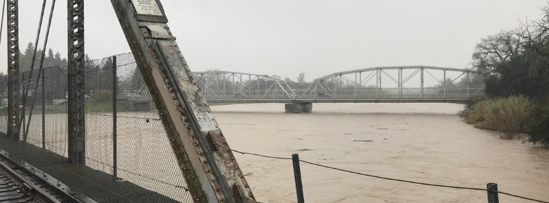
Image credit: NWS Bay Area
A slow-moving storm brought widespread heavy precipitation across central to northern California and very heavy snow through the Sierra on February 26 and 27, 2019. The County of Sonoma has issued mandatory evacuations to residents living near the Russian River. Russian River at Guerneville is now at major flood level and is forecast to peak late Wednesday evening, February 27 at 14.05 m (46.1 feet). All roads in and out of Guerneville are now closed.
Santa Rosa obliterated its February and all-time 1-day rainfall record on February 26 with 141.22 mm (5.56 inches) of rain.
The city's previous all-time 1-day rainfall record was 132.84 mm (5.23 inches) set on December 19, 1981. Its previous 1-day February record was 46.22 mm (1.82 inches) set 100 years ago in 1919.
The station is located in the City of Santa Rosa proper and dates back to 1902.
From February 1 to 27, Santa Rosa registered a total of 372.36 mm (14.66 inches) of rain, making this month its 3rd wettest February on record.
The wettest February ever measured in the city was in 1998 with 493.26 mm (19.42 inches) followed by 404.87 mm (15.94 inches) in 1986.
The worst of the rain hit Venado, where 520.19 mm (20.48 inches) of rain fell in 48 hours to 04:19 PST, February 27 (12:19 UTC).
22 river gauges across the state are showing minor to major flood levels at 13:00 UTC on February 27. 4 of them are in major flood stage, all of them in Sonoma County around Santa Rosa – Russian River at Jimtown, Russian River at Guerneville, Mark West Creek near Mirabel Heights and Willow Brook at Penngrove Park.
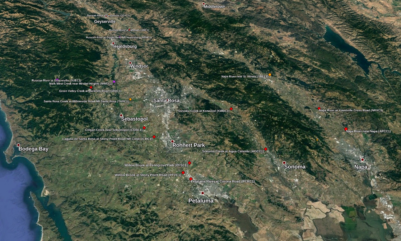
River Gauges at 13:00 UTC on February 27, 2019. Credit: Google, NWS, TW
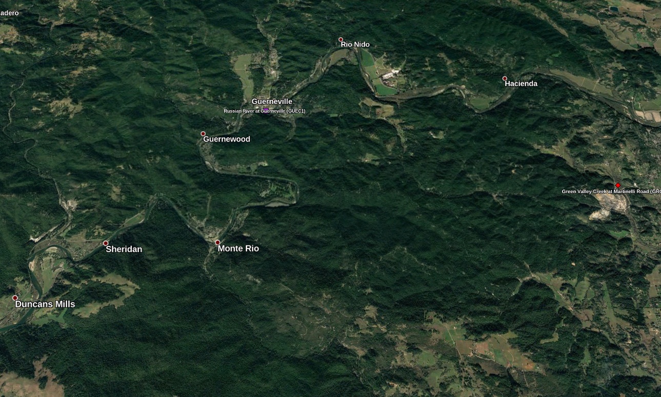
Guerneville area, Sonoma County, California. Credit: Google, TW
Sonoma Country officials issued a mandatory evacuation order for residents living near the Russian River at 14:00 PST, February 26.
The river is projected to crest at 14.05 m (46.1 feet) at 22:00 PST, February 27. If the forecasted peak turns out to be correct, it would be the sixth highest on record – 15.08 m (49.5 feet).
As of early February 27, all roads leading to Guerneville are flooded, leaving no way in or out of the community, the Sonoma County Sheriff said.
Updated 48 hour rainfall reports: highest total at Venado (Sonoma County) with an incredible 20.48". For other totals, see https://t.co/CMl2U4NtpI#CAwx pic.twitter.com/7dJySGa9jy
— NWS Bay Area (@NWSBayArea) February 27, 2019
GOES-17 IR imagery (channel 15) shows the #AtmosphericRiver impacting north of the Golden Gate through the day. A sharp contrast in rain reports: 5+" of rain has been observed today in parts of the North Bay while Downtown San Francisco has only recorded 0.37". #CAwx pic.twitter.com/OlTJQJsa6e
— NWS Bay Area (@NWSBayArea) February 27, 2019
#RussianRiver at #Guerneville forecast to peak at 46.1 feet late Wednesday evening (major flood). This would be the sixth highest level on the Russian River in Guerneville, and the highest since 1995. #CAwx #CAflood #CAstorm pic.twitter.com/9zFQyyBXjT
— NWS Bay Area (@NWSBayArea) February 27, 2019
I feel like I'm living in a perpetual state of disaster here in California. Floods are eerie at night, as Guerneville and the rest of the Russian River Area brace for more flooding. @NorthBayNews @NWSBayArea #cawx #AtmosphericRiver #CAstorm pic.twitter.com/sCn4Kx8h7p
— Kent Porter (@kentphotos) February 27, 2019
Flood Warnings remain in effect for the Napa River near Napa and near St Helena as well as the Russian River at Johnsons Beach near Guerneville and near Healdsburg. Major flooding is forecast for the Russian River near Guerneville Weds and Weds night.#cawx pic.twitter.com/xGEM7qFQ42
— NWS Bay Area (@NWSBayArea) February 27, 2019
48 Hour Rainfall Reports: highest totals at Venado which has exceeded 18"https://t.co/eGCBgq7j5Z
24 Hour Peak Wind gusts: highest gust of 73 mph near Lucas Valley-Marinwoodhttps://t.co/0sdGIL54Xs#cawx
— NWS Bay Area (@NWSBayArea) February 27, 2019
Upon further review, the 5.66" of rain that fell in Santa Rosa today would break the all-time daily precipitation record for the climate site. Records for the City of Santa Rosa go back to 1902. @NWSWPC #CAwx pic.twitter.com/pTabEztYaR
— NWS Bay Area (@NWSBayArea) February 27, 2019
48 hour rainfall totals. These values will certainly change as more rain falls across the region. Over 10" so far in in the #NorthBay for a more detailed list https://t.co/UCvqP1GbcO #cawx #AtmosphericRiver pic.twitter.com/oBFekTlu22
— NWS Bay Area (@NWSBayArea) February 26, 2019
#AtmosphericRiver viewed from space Additional pulses of moisture will bring periods of moderate to heavy rain to the #BayArea through Wednesday. #cawx #caflood pic.twitter.com/mfEKUsloe9
— NWS Bay Area (@NWSBayArea) February 26, 2019
Wondering why all the rain has been focused over the North Bay? GOES East water vapor imagery overlayed with surface analysis shows the main moisture band moving over northern California along a stalled frontal boundary. Expecting rain to slowly move southward later today.#cawx pic.twitter.com/l6JLWfbfxl
— NWS Bay Area (@NWSBayArea) February 26, 2019
It's windy out there! Here are some of the top gusts over the last 12 hours. For a more complete list : https://t.co/EH9CqAeegY #cawx pic.twitter.com/g7dvlTYfVl
— NWS Bay Area (@NWSBayArea) February 26, 2019
A mudslide took place on Bohemian Highway on Tuesday afternoon, closing the roadway in both directions near Monte Rio, not far from Guerneville. This was one of two routes available for those evacuating due to Russian River flooding. The other way out was through Highway 16 which is now closed too.
Two people got stuck in the mudslide and were later rescued.
Dozens of other mudslides were reported in Sonoma and Plumas counties, blocking lanes or entire portions of Highways 1, 116, 128 and 70.
Authorities said many water rescues were executed as motorists found themselves stranded in as much as 30 cm (1 foot) of flowing water.
I'm a dedicated researcher, journalist, and editor at The Watchers. With over 20 years of experience in the media industry, I specialize in hard science news, focusing on extreme weather, seismic and volcanic activity, space weather, and astronomy, including near-Earth objects and planetary defense strategies. You can reach me at teo /at/ watchers.news.
Commenting rules and guidelines
We value the thoughts and opinions of our readers and welcome healthy discussions on our website. In order to maintain a respectful and positive community, we ask that all commenters follow these rules.