Lane’s center to pass dangerously close or hit Hawaii. Officials: not enough shelters for everyone
The latest forecast track from the Central Pacific Hurricane Center brings the center of Lane dangerously close to the Hawaiian Islands during the Thursday through Saturday time frame, August 23 to 25. Regardless of the exact track of the storm, life-threatening impacts are likely over many areas as this strong hurricane makes its closest approach. All individuals in Hawaii are urged not to focus on the exact forecast track or intensity of Lane, and be prepared for adjustments in future forecast updates. Although the official forecast does not explicitly indicate Lane's center making landfall over any of the islands, this could still occur, CPHC said. Outer rain bands and embedded thunderstorms associated with Hurricane "Lane," are already producing heavy rainfall and flash flooding on the Big Island.
Hawaii officials have warned residents that there will not be enough shelter space for everyone during the passage of Hurricane "Lane."
All those who can fortify their homes are asked to do so and stay there. However, residents in flood zones should not stay home during the storm; they should find another place to go.
"We do not have enough shelters for everyone," Tom Travis, head of Hawaii's Emergency Management Agency, said. "If you're not in a flood zone, most citizens should remain in their homes. If you are in a flood zone, you should actively seek shelters elsewhere."
According to a report issued earlier this year, there are only 277 376 available shelter spaces in the entire state. Hawaii has 1.4 million residents, not taking into account the tourists visiting the state.
Hurricane "Lane" remains a major category 4 storm today, with maximum sustained winds of 215 km/h (130 mph) at 15:00 UTC, August 23. It was located 335 km (210 miles) SSW of Kailua-Kona and 490 km (305 miles) S of Honolulu, Hawaii at the time, and moving northwestward at around 11 km/h (7 mph).
A turn toward the north-northwest and little change in forward speed is expected today, followed by a turn toward the north tonight and Friday, August 23 as Lane's forward motion slows. A turn toward the west is expected on Saturday and Sunday, August 25 and 26 with an increase in forward speed. On the forecast track, the center of Lane will move very close to or over the portions of the main Hawaiian islands later today through Friday.
Regardless of the exact track of the storm, llife-threatening impacts are likely over many areas as this strong hurricane makes its closest approach. All individuals in Hawaii are urged not to focus on the exact forecast track or intensity of Lane, and be prepared for adjustments in future forecast updates. Although the official forecast does not explicitly indicate Lane's center making landfall over any of the islands, this could still occur.
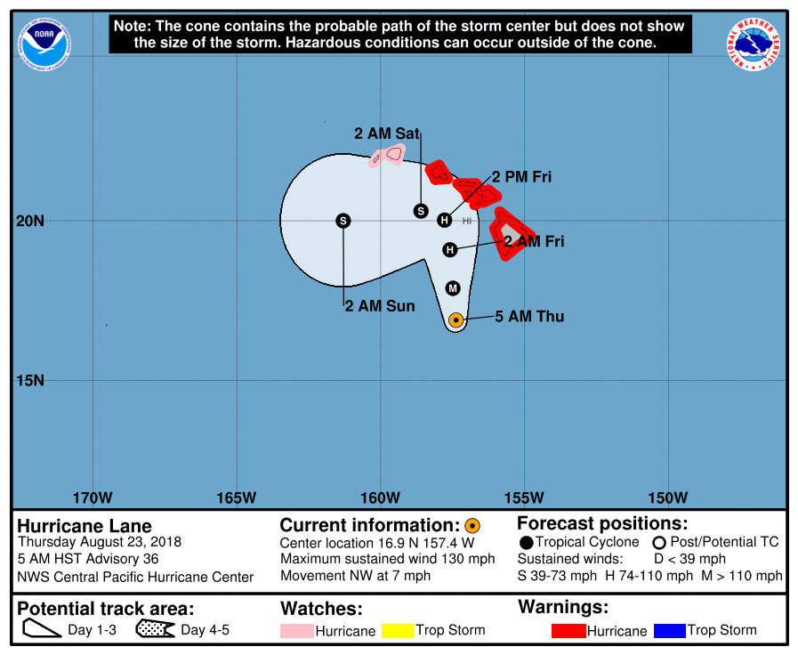
A Hurricane Warning is in effect for Oahu, Maui County (including the islands of Maui, Lanai, Molokai and Kahoolawe), and Hawaii County.
A Hurricane Warning means that hurricane conditions are expected somewhere within the warning area. A warning is typically issued 36 hours before the anticipated first occurrence of tropical-storm-force winds, conditions that make outside preparations difficult or dangerous. Preparations to protect life and property should be rushed to completion.
A Hurricane Watch is in effect for Kauai County, including the islands of Kauai and Niihau.
A Hurricane Watch means that hurricane conditions are possible within the watch area. A watch is typically issued 48 hours before the anticipated first occurrence of tropical-storm-force winds, conditions that make outside preparations difficult or dangerous.
Interests in the Northwestern Hawaiian Islands should monitor the progress of Hurricane "Lane".
The onset of damaging tropical storm-force winds on the Big Island could occur by early Thursday morning (local time), with dangerous hurricane force winds expected in some areas Thursday afternoon or Thursday night (local time). In Maui County, damaging tropical storm-force winds could begin late Thursday, with dangerous hurricane force winds expected Thursday night into Friday. On Oahu, damaging tropical storm force winds could begin as early as late Thursday night, with dangerous hurricane force winds expected Friday into Friday night. Hurricane Warnings may need to be expanded to Kauai County as Lane draws closer.
Outer rain bands and embedded thunderstorms associated with Hurricane "Lane," are already producing heavy rainfall and flash flooding on the Big Island. Bands of intense showers and thunderstorms will continue to spread across the other islands from south-southeast to north-northwest tonight through Friday.
Excessive rainfall is likely which could result in life threatening flash flooding, as well as landslides and mudslides. Flooding from these heavy rains will also be possible in areas that are typically not prone to flooding. Storm total rainfall amounts greater than 762 mm (30 inches) are possible.
Swells generated by Lane will produce very large and rough surf, with dangerous rip currents along south, southeast and southwest facing shores. Large surf is already occurring along southeast facing shores of the Big Island. Surf is expected to increase later tonight and Thursday along southwest facing shores of the Big Island as well as along south and southeast facing shores from Maui County to Kauai County.
Tornadoes and large waterspouts will be possible with Lane, mainly along and to the right of the track of the hurricane.
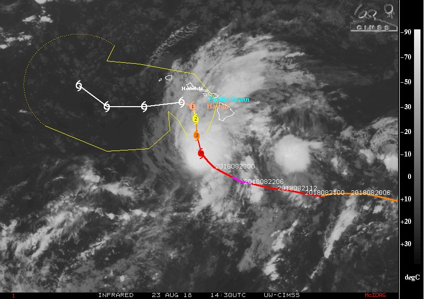
Credit: UW-CIMSS
Potential impacts
FLOODING RAIN:
Protect against life-threatening rainfall flooding having possible devastating impacts across the Hawaiian islands.
Potential impacts include:
- Extreme rainfall flooding may prompt numerous evacuations and rescues.
- Rivers and tributaries may overwhelmingly overflow their banks in many places with deep moving water. Small streams, creeks, canals, arroyos, and ditches may become raging rivers. In mountain areas, deadly runoff may rage down valleys while increasing susceptibility to rockslides and mudslides. Flood control systems and barriers may become stressed.
- Flood waters can enter numerous structures within multiple communities, some structures becoming uninhabitable or washed away. Numerous places where flood waters may cover escape routes. Streets and parking lots become rivers of raging water with underpasses submerged. Driving conditions become very dangerous. Numerous road and bridge closures with some weakened or washed out.
WIND:
Protect against life-threatening wind having possible extensive impacts across Maui County, Oahu, and western and southern sections of the Big Island.
Potential impacts in this area include:
- Considerable roof damage to sturdy buildings, with some having window, door, and garage door failures leading to structural damage. Mobile homes severely damaged, with some destroyed. Damage accentuated by airborne projectiles. Locations may be uninhabitable for weeks.
- Many large trees snapped or uprooted along with fences and roadway signs blown over.
- Some roads impassable from large debris, and more within urban or heavily wooded places. Several bridges, causeways, and access routes impassable.
- Large areas with power and communications outages.
Also, protect against dangerous wind having possible significant impacts across the northern and eastern sections of the Big Island and Kauai.
SURGE:
Protect against life-threatening surge having possible significant impacts across southeast, south and southwest facing coastlines. Potential impacts in this area include:
- Areas of inundation with storm surge flooding accentuated by waves. Damage to several buildings, mainly near the coast.
- Sections of near-shore escape routes and secondary roads become weakened or washed out, especially in usually vulnerable low spots.
- Major beach erosion with heavy surf breaching dunes. Strong and numerous rip currents.
- Moderate damage to marinas, docks, boardwalks, and piers. Several small craft broken away from moorings, especially in unprotected anchorages.
Elsewhere across the Hawaiian islands, little to no surge impact is expected at this time.
TORNADOES:
Protect against a tornado event having possible limited impacts across the Hawaiian islands. Potential impacts include:
- The occurrence of isolated tornadoes can hinder the execution of emergency plans during tropical events.
- A few places may experience tornado damage, along with power and communications disruptions.
- Locations could realize roofs peeled off buildings, chimneys toppled, mobile homes pushed off foundations or overturned, large tree tops and branches snapped off, shallow-rooted trees knocked over, moving vehicles blown off roads, and small boats pulled from moorings.
Precautionary/preparedness actions
EVACUATIONS:
Listen to local official for recommended preparedness actions, including possible evacuation. If ordered to evacuate, do so immediately.
For those not under evacuation orders, assess the risk from wind, falling trees, and flooding at your location. If you decide to move, relocate to a safer location nearby. If you do not relocate, help keep roadways open for those under evacuation orders.
If evacuating, leave with a destination in mind and allow extra time to get there. Take your emergency supplies kit. Gas up your vehicle ahead of time.
Let others know where you are going prior to departure. Secure loose items and pets in the car, and avoid distracted driving.
If evacuating, follow designated evacuation routes. Seek traffic information on roadway signs, the radio, and from official sources.
Do not enter evacuated areas until officials have given the all clear to return.
OTHER PREPAREDNESS INFORMATION:
Now is the time to complete all preparations to protect life and property in accordance with your emergency plan. Ensure you are in a safe location before the onset of strong winds or possible flooding.
If you are relocating to safe shelter, leave as early as possible. Allow extra time to reach your destination. Many roads and bridges will be closed once strong winds arrive. Check the latest weather forecast before departing and drive with caution.
Failure to adequately shelter may result in serious injury or loss of life. Always heed the advice of local officials and comply with any orders that are issued. Remember, during the storm 9 1 1 Emergency Services may not be able to immediately respond if conditions are unsafe. This should be a big factor in your decision making.
Keep cell phones well charged. Cell phone chargers for automobiles can be helpful, but be aware of your risk for deadly carbon monoxide poisoning if your car is left idling in a garage or other poorly ventilated area.
It is important to remain calm, informed, and focused during an emergency. Be patient and helpful with those you encounter.
If you are a visitor, be sure to know the name of the city or town in which you are staying and the name of the county or parish in which it resides. Listen for these locations in local news updates. Pay attention for instructions from local authorities.
Rapidly rising flood waters are deadly. If you are in a flood-prone area, consider moving to higher ground. Never drive through a flooded roadway. Remember, turn around don't drown!
If in a place that is vulnerable to high wind, such as near large trees, a manufactured home, upper floors of a high-rise building, or on a boat, consider moving to a safer shelter before the onset of strong winds or flooding.
Closely monitor weather.gov, NOAA Weather radio or local news outlets for official storm information. Be ready to adapt to possible changes to the forecast. Ensure you have multiple ways to receive weather warnings.
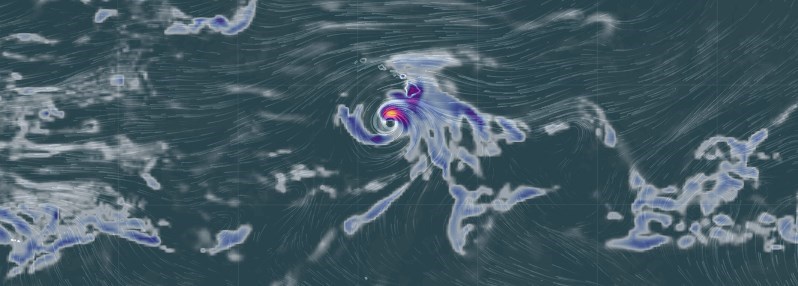
Featured image:3hr Precipitation Accumulation, valid 15:00 UTC, August 23, 2018. Credit: earth.nullschool.net
Amos 3:6 read: If a trumpet is blown in a city will not the people tremble? If a calamity occurs in a city has not the Lord dune it? Right after the trumpets from the sky was heard in Howie, it has been desaster upon desasters happening as you can now see, and soon the children of God and of Zion who are truly the blacks of slavery and also some people from among them from other nations that God did not choose will have them a feast day of gladness that all of you nations did try to hide from them. That day will be on the seventh day of the true fourth month of this Sunday August 26th 2018. That day is truly called the 25th day of the fourth month of this new year that did began on May 1st of this year. So starting at the time of the new moon that is truly called a full moon the feast day will begin to happen, but only for all of those he has chosen to come home to the land of the Northern lights the great city! Up on the very high mountain Will go home! For it will happen just as it reads at. Psalm 81:3-4 “Blow the trumpet at the new moon, at the full moon on our feast day! For it is a statute for Isreal, An ordinance of the God of Jacob.