
Very strong and deep M7.1 earthquake hits Peru-Brazil border region
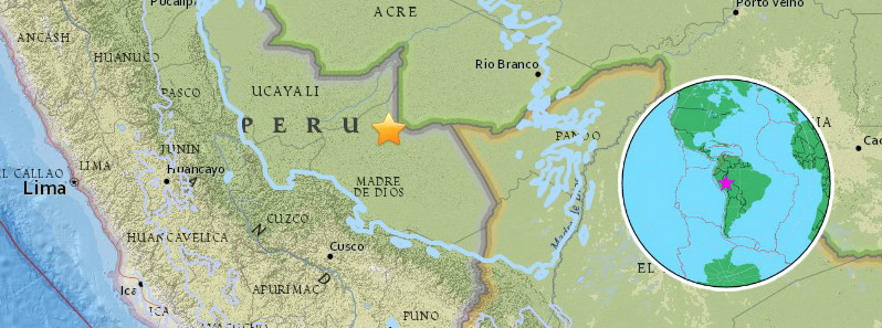
Image credit: USGS, EMSC
A very strong and deep earthquake registered by the USGS ad M7.1 hit Peru-Brazil border region at 09:04 UTC (04:04 local time) on August 24, 2018. The agency is reporting a depth of 609.5 km (378.7 miles). EMSC is reporting Mw7.0 at a depth of 651 km (404.5 miles).
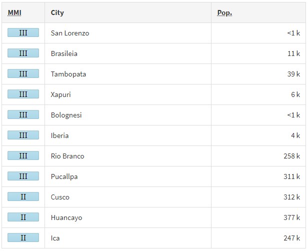
According to the USGS, the epicenter was located 135.2 km (84 miles) W of Iñapari (population 0), Peru, 223.8 km (139 miles) W of Cobija, Bolivia and 226.1 km (140.5 miles) W of Brasileia (population 11 200), Brazil.
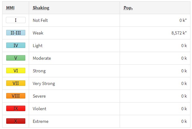
There are about 2 000 people living within 100 km (62 miles).
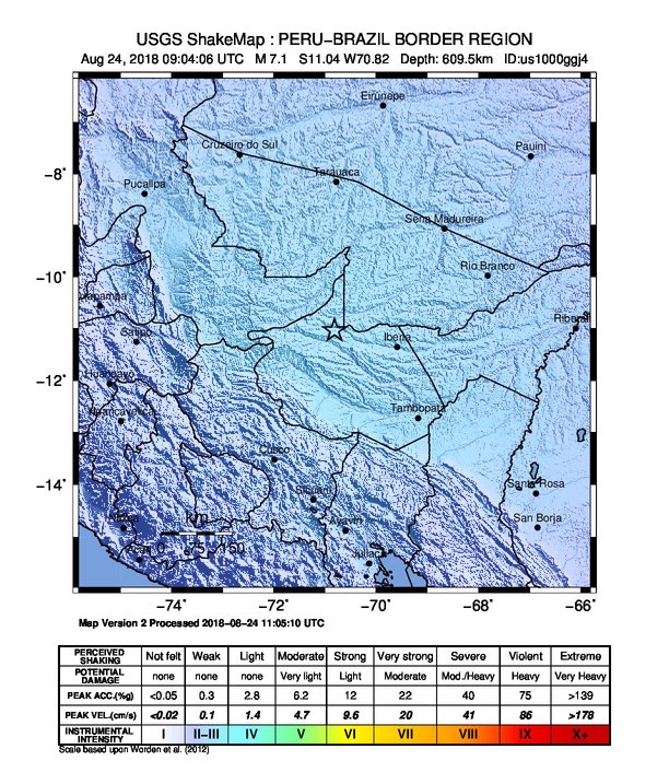
The USGS issued a green alert for shaking-related fatalities and economic losses. There is a low likelihood of casualties and damage.
Overall, the population in this region resides in structures that are vulnerable to earthquake shaking, though resistant structures exist. The predominant vulnerable building types are mud wall and informal (metal, timber, GI etc.) construction.
Recent earthquakes in this area have caused secondary hazards such as landslides that might have contributed to losses.
Estimated population exposure to earthquake shaking
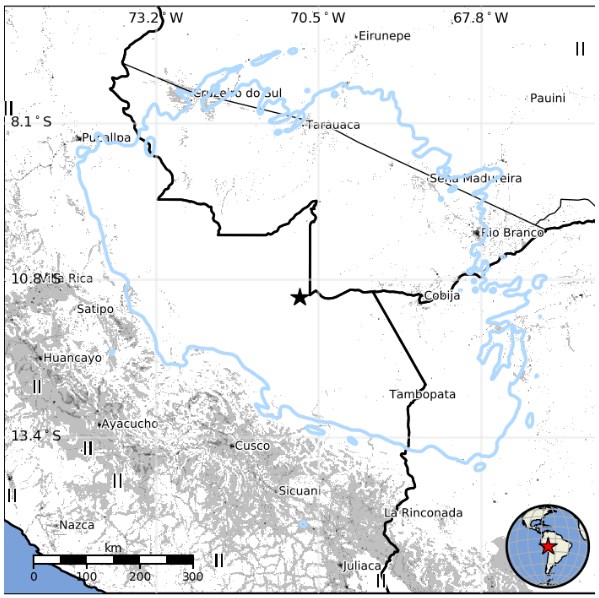
Selected cities exposed
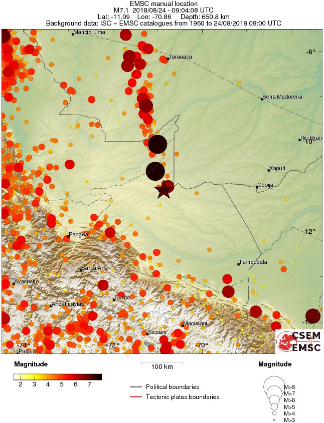
Regional seismicity
Tectonic summary
The August 24, 2018, M7.1 earthquake near the Peru-Brazil border in southeast Peru occurred as the result of normal faulting at a depth of approximately 610 km. This earthquake occurred within the oceanic lithosphere of the subducted Nazca plate, almost 1 000 km east of the Peru-Chile Trench. Focal mechanism solutions indicate that rupture occurred on either a northwest or southeast-striking, moderately dipping normal fault. Slip on a fault of either orientation would accommodate the down-dip extension of the Nazca slab that is implied by the normal component of the faulting solution. At the location of the earthquake, the Nazca plate subducts to the east under the South America plate at a velocity of about 69 mm/yr.
As it descends eastward from the Peru-Chile Trench off the west coast of Peru, the Nazca plate is seismically active down to depths of about 200 km. Between depths of 200 and 500 km, where the Nazca plate subducts beneath eastern Peru, very few earthquakes are produced. Beneath Peru and Brazil in the border region near the August 24th earthquake, the subducted Nazca plate is again seismically active between depths of about 500 and 650 km. The deep part of the Nazca plate, in which the August 24th, 2018, earthquakes occurred, took 10 Myr or more to descend from the point at which it initially thrust under the South America plate.
Earthquakes that have focal depths greater than 300 km are commonly termed "deep-focus" earthquakes. Deep-focus earthquakes cause less damage on the ground surface above their foci than similar-magnitude shallow-focus earthquakes, but large deep-focus earthquakes may be felt at great distance from their epicenters. The largest recorded deep-focus earthquake was a M8.3 event that occurred at a depth of 600 km within the subducted Pacific plate beneath the Sea of Okhotsk offshore of northeastern Russia in 2013. The M8.3 Okhotsk earthquake was felt all over Asia, as far away as Moscow, and across the Pacific Ocean along the western seaboard of the United States (though at distant locations, individuals reporting having felt the event were likely very favorably situated for the perception of small ground motions). Prior to 2013, the largest recorded deep-focus earthquake was a M8.2 event that occurred at a depth of 630 km within the subducted Nazca plate near the northern Bolivian border in 1994, approximately 450 km southeast of the August 24, 2018 event. The M8.2 Bolivian deep-focus earthquake in 1994 had similarly been reported by individuals in North America at great distance from the epicenter.
Over the past century, 95 earthquakes of M 7+ have occurred at depths greater than 300 km globally; 12 of these were located in the same region as the August 24, 2018 event. The largest nearby events at these depths were a doublet of M7.6 earthquakes 60-110 km to the northwest of the August 24, 2018 earthquake in November 2015.
Seismotectonics of South America (Nazca plate region)
The South American arc extends over 7,000 km, from the Chilean margin triple junction offshore of southern Chile to its intersection with the Panama fracture zone, offshore of the southern coast of Panama in Central America. It marks the plate boundary between the subducting Nazca plate and the South America plate, where the oceanic crust and lithosphere of the Nazca plate begin their descent into the mantle beneath South America. The convergence associated with this subduction process is responsible for the uplift of the Andes Mountains, and for the active volcanic chain present along much of this deformation front. Relative to a fixed South America plate, the Nazca plate moves slightly north of eastwards at a rate varying from approximately 80 mm/yr in the south to approximately 65 mm/yr in the north. Although the rate of subduction varies little along the entire arc, there are complex changes in the geologic processes along the subduction zone that dramatically influence volcanic activity, crustal deformation, earthquake generation and occurrence all along the western edge of South America.
Most of the large earthquakes in South America are constrained to shallow depths of 0 to 70 km resulting from both crustal and interplate deformation. Crustal earthquakes result from deformation and mountain building in the overriding South America plate and generate earthquakes as deep as approximately 50 km. Interplate earthquakes occur due to slip along the dipping interface between the Nazca and the South American plates. Interplate earthquakes in this region are frequent and often large, and occur between the depths of approximately 10 and 60 km. Since 1900, numerous magnitude 8 or larger earthquakes have occurred on this subduction zone interface that were followed by devastating tsunamis, including the 1960 M9.5 earthquake in southern Chile, the largest instrumentally recorded earthquake in the world. Other notable shallow tsunami-generating earthquakes include the 1906 M8.5 earthquake near Esmeraldas, Ecuador, the 1922 M8.5 earthquake near Coquimbo, Chile, the 2001 M8.4 Arequipa, Peru earthquake, the 2007 M8.0 earthquake near Pisco, Peru, and the 2010 M8.8 Maule, Chile earthquake located just north of the 1960 event.
Large intermediate-depth earthquakes (those occurring between depths of approximately 70 and 300 km) are relatively limited in size and spatial extent in South America, and occur within the Nazca plate as a result of internal deformation within the subducting plate. These earthquakes generally cluster beneath northern Chile and southwestern Bolivia, and to a lesser extent beneath northern Peru and southern Ecuador, with depths between 110 and 130 km. Most of these earthquakes occur adjacent to the bend in the coastline between Peru and Chile. The most recent large intermediate-depth earthquake in this region was the 2005 M7.8 Tarapaca, Chile earthquake.
Earthquakes can also be generated to depths greater than 600 km as a result of continued internal deformation of the subducting Nazca plate. Deep-focus earthquakes in South America are not observed from a depth range of approximately 300 to 500 km. Instead, deep earthquakes in this region occur at depths of 500 to 650 km and are concentrated into two zones: one that runs beneath the Peru-Brazil border and another that extends from central Bolivia to central Argentina. These earthquakes generally do not exhibit large magnitudes. An exception to this was the 1994 Bolivian earthquake in northwestern Bolivia. This M8.2 earthquake occurred at a depth of 631 km, which was until recently the largest deep-focus earthquake instrumentally recorded (superseded in May 2013 by a M8.3 earthquake 610 km beneath the Sea of Okhotsk, Russia), and was felt widely throughout South and North America.
Subduction of the Nazca plate is geometrically complex and impacts the geology and seismicity of the western edge of South America. The intermediate-depth regions of the subducting Nazca plate can be segmented into five sections based on their angle of subduction beneath the South America plate. Three segments are characterized by steeply dipping subduction; the other two by near-horizontal subduction. The Nazca plate beneath northern Ecuador, southern Peru to northern Chile, and southern Chile descend into the mantle at angles of 25° to 30°. In contrast, the slab beneath southern Ecuador to central Peru, and under central Chile, is subducting at a shallow angle of approximately 10° or less. In these regions of “flat-slab” subduction, the Nazca plate moves horizontally for several hundred kilometers before continuing its descent into the mantle, and is shadowed by an extended zone of crustal seismicity in the overlying South America plate. Although the South America plate exhibits a chain of active volcanism resulting from the subduction and partial melting of the Nazca oceanic lithosphere along most of the arc, these regions of inferred shallow subduction correlate with an absence of volcanic activity. (USGS)
I'm a dedicated researcher, journalist, and editor at The Watchers. With over 20 years of experience in the media industry, I specialize in hard science news, focusing on extreme weather, seismic and volcanic activity, space weather, and astronomy, including near-Earth objects and planetary defense strategies. You can reach me at teo /at/ watchers.news.
Commenting rules and guidelines
We value the thoughts and opinions of our readers and welcome healthy discussions on our website. In order to maintain a respectful and positive community, we ask that all commenters follow these rules.