
Strong and shallow M6.0 earthquake hits near the coast of Jalisco, Mexico
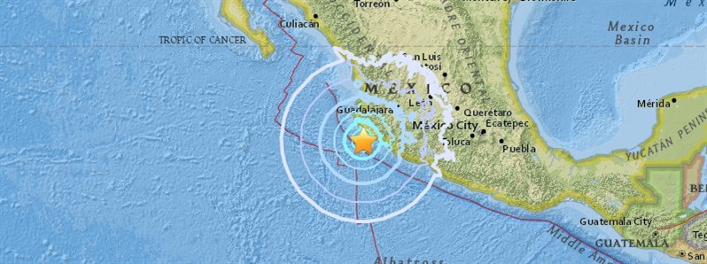
Image credit: USGS
A strong and shallow earthquake registered by the USGS as M6.0 hit near the coast of Jalisco, Mexico at 03:56 UTC on June 30, 2018 (22:56 local time, June 29). The agency is reporting a depth of 24.8 km (15.4 miles). EMSC is reporting Mw 6.0 at a depth of 44 km (27.3 miles). This earthquake can have a low humanitarian impact based on the magnitude and the affected population and their vulnerability.
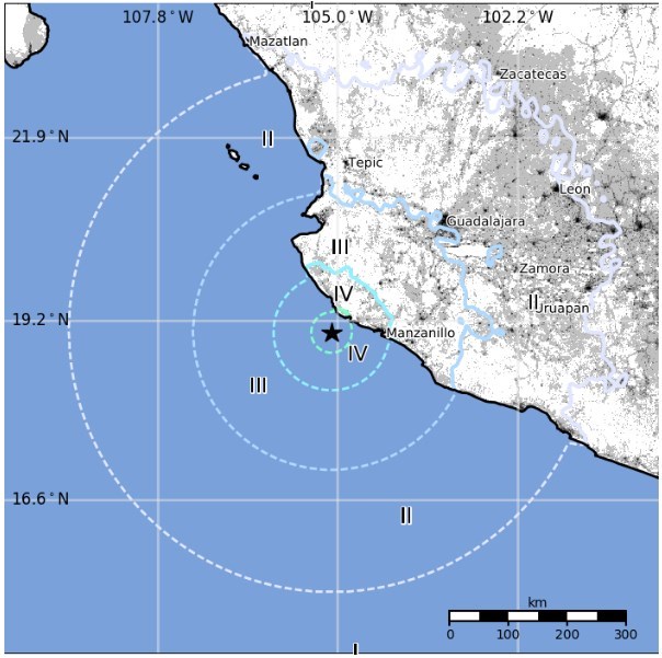
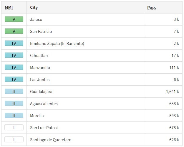
According to the USGS, the epicenter was located 43.9 km (27.3 miles) WSW of Emiliano Zapata (El Ranchito / population 1 831), 58.5 km (36.4 miles) WSW of Cihuatlan (population 16 520), 79.2 km (49.2 miles) W of Manzanillo (population 110 735), and 145.1 km (90.1 miles) W of Colima (127 235), Mexico.
There are about 300 000 people living within 100 km (62 miles).
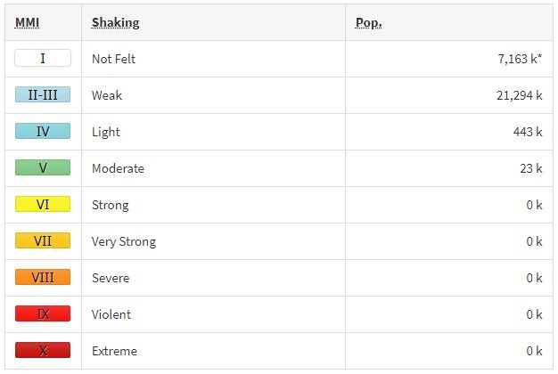
Some 23 000 people are estimated to have felt moderate shaking and 443 000 light.
According to 'I felt it' reports, the quake was felt up to 250 km (155 miles) from the epicenter.
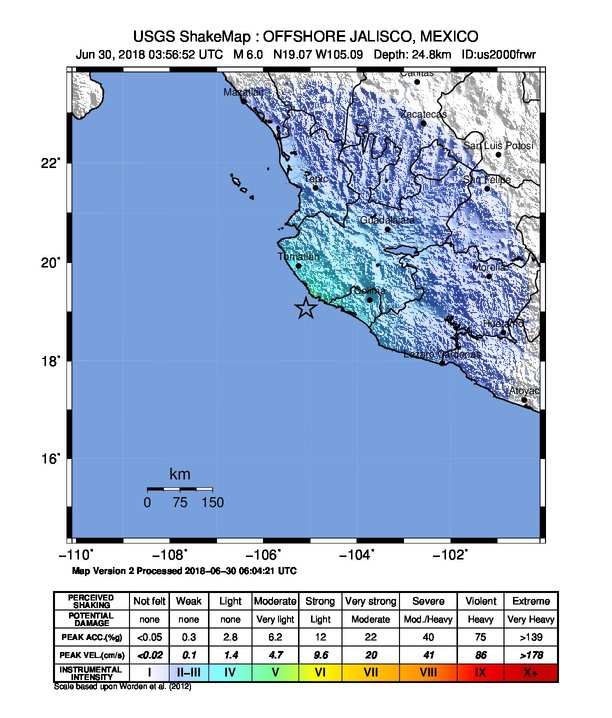
The USGS issued a green alert for shaking-related fatalities and economic losses. There is a low likelihood of casualties and damage.
Overall, the population in this region resides in structures that are a mix of vulnerable and earthquake resistant construction. The predominant vulnerable building types are mud wall and adobe block with concrete bond beam construction.
Recent earthquakes in this area have caused secondary hazards such as landslides that might have contributed to losses.
Estimated population exposure to earthquake shaking
Selected cities exposed
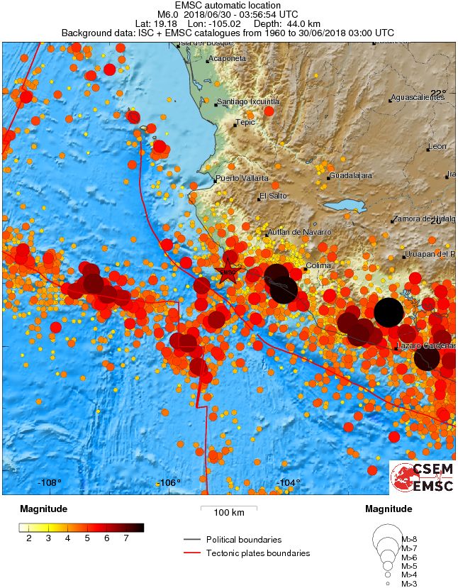
Regional seismicity
Seismotectonics of Mexico
Located atop three of the large tectonic plates, Mexico is one of the world's most seismically active regions. The relative motion of these crustal plates causes frequent earthquakes and occasional volcanic eruptions. Most of the Mexican landmass is on the westward moving North American plate. The Pacific Ocean floor south of Mexico is being carried northeastward by the underlying Cocos plate. Because oceanic crust is relatively dense, when the Pacific Ocean floor encounters the lighter continental crust of the Mexican landmass, the ocean floor is subducted beneath the North American plate creating the deep Middle American trench along Mexico's southern coast. Also as a result of this convergence, the westward moving Mexico landmass is slowed and crumpled creating the mountain ranges of southern Mexico and earthquakes near Mexico's southern coast. As the oceanic crust is pulled downward, it melts; the molten material is then forced upward through weaknesses in the overlying continental crust. This process has created a region of volcanoes across south-central Mexico known as the Cordillera Neovolcánica.
The area west of the Gulf of California, including Mexico's Baja California Peninsula, is moving northwestward with the Pacific plate at about 50 mm per year. Here, the Pacific and North American plates grind past each other creating strike-slip faulting, the southern extension of California's San Andreas fault. In the past, this relative plate motion pulled Baja California away from the coast forming the Gulf of California and is the cause of earthquakes in the Gulf of California region today.
Mexico has a long history of destructive earthquakes and volcanic eruptions. In September 1985, a magnitude 8.0 earthquake killed more than 9,500 people in Mexico City. In southern Mexico, Volcán de Colima and El Chichón erupted in 2005 and 1982, respectively. Paricutín volcano, west of Mexico City, began venting smoke in a cornfield in 1943; a decade later this new volcano had grown to a height of 424 meters. Popocatépetl and Ixtaccíhuatl volcanos ("smoking mountain" and "white lady", respectively), southeast of Mexico City, occasionally vent gas that can be clearly seen from the City, a reminder that volcanic activity is ongoing. In 1994 and 2000 Popocatépetl renewed its activity forcing the evacuation of nearby towns, causing seismologists and government officials to be concerned about the effect a large-scale eruption might have on the heavily populated region. Popocatépetl volcano last erupted in 2010.
I'm a dedicated researcher, journalist, and editor at The Watchers. With over 20 years of experience in the media industry, I specialize in hard science news, focusing on extreme weather, seismic and volcanic activity, space weather, and astronomy, including near-Earth objects and planetary defense strategies. You can reach me at teo /at/ watchers.news.
Commenting rules and guidelines
We value the thoughts and opinions of our readers and welcome healthy discussions on our website. In order to maintain a respectful and positive community, we ask that all commenters follow these rules.