
3 dead, 480 000 without power, numerous records broken as winter storm hits US South
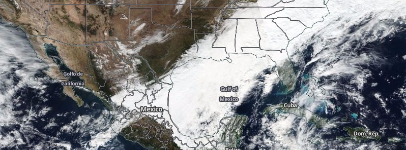
Featured image: Winter Storm Benji - December 8, 2017. Credit: NASA/NOAA Suomi NPP/VIIRS
Nearly 500 000 people were left without power and three have died as a suprisingly strong early winter storm hit the US South on its way toward the Northeast. The storm dumped rare snow on the Deep South, in many places record-breaking for December. Relatively quiet weather is expected across much of the country today as the storm continues to pull away from the Northeast Sunday morning. There is a chance for light snow showers in the Northeast today and tonight but the greatest snowfall accumulations are expected east of lakes Erie and Ontario due to lake effect snow.
The storm blanketed parts of the Deep South this week with up to 46 cm (18 inches) of snow in places, causing traffic chaos and leaving more than 480 000 people without power as of Saturday morning, December 9, 2017. More than 334 000 homes and businesses were still without power Saturday afternoon in Georgia (235 000), Alabama, Mississippi and Louisiana. Over 170 000 woke up Sunday still without power; 125 000 in Georgia, 17 000 in Alabama, another 17 000 in Louisiana and 12 000 in North Carolina.
Snow started falling in Houston, Texas on December 8, making it the second earliest snowfall on record. The city saw widespread snow amounts between 2.5 and 7.6 cm (1 and 3 inches) and recorded its first measurable snowfall in 8 years.
On the same day, Brownsville, TX had its third accumulating snowfall since records began in 1895. By Saturday morning, the city received 35 cm (14.5 inches) of snow. Corpus Christi, TX had its first snowfall in 13 years (since 2004) and recorded between 12.7 and 17.8 cm (5 and 7 inches) within 24 hours as well as extremely rare thundersnow.
Hendersonville, North Carolina received up to 30 cm (12 inches) in places, and Asheville, NC up to 20 cm (8 inches) by Saturday morning. Up to 25 cm (10 inches) was recorded in northwest Georgia, with 18 cm (7 inches) in parts of metro Atlanta. 25 cm (10 inches) was recorded in Anniston, Alabama and up to 18 cm (7 inches) in Mississippi.
Sid King, a meteorologist for the National Weather Service in the Atlanta area described snow totals as very, very abnormal and rare. "It’s really not even winter yet. I would not be surprised if we broke a lot of records," he said Friday.
The December 8th snow across Central Alabama was the biggest one for so early in the season, meteorologist James Span said. Data is still being compiled, Span said Saturday, but for Birmingham, with an official total of 10.1 cm (4 inches), it was the third snowiest December day on record. Only surpassed by 20.3 cm (8 inches) during the famous New Year’s Eve event on December 31, 1963, and 14 cm (5.5 inches) on December 22, 1929.
Nearly 1 200 flights were canceled at the Hartsfield-Jackson Atlanta International Airport Friday and more than 400 on Saturday.
Sadly, the storm is responsible for the deaths of at least 3 people. One man died in Georgia after being electrocuted by a downed power line. Bystanders tried to warn the man before he walked into the dangling live wire, Atlanta police Sgt. John Chafee said Saturday. The two other victims are a 27-year-old woman and a 5-year-old boy who died in a car crash in Virginia. The driver apparently lost control of the car and hit a guardrail, which caused the vehicle to spin into the path of a truck.
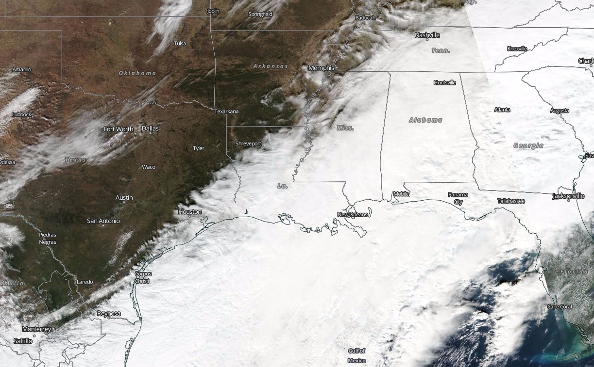
Winter Storm Benji on December 8, 2017. Credit: NASA/NOAA Suomi NPP/VIIRS
US South on December 9, 2017. Notice snow line stretching from SE Louisiana, Mississippi, Alabama, Georgia, Tennessee and into Virginia. Credit: NASA/NOAA Suomi NPP/VIIRS
Relatively quiet weather will be in store for much of the country as the winter storm continues to pull away from the Northeast Sunday morning, NWS said.
A quick moving and moisture starved upper level disturbance will bring a chance of light snow showers to the Northeast today/tonight but the greatest snowfall accumulations will be east of lakes Erie and Ontario due to lake effect snow where local totals up to a foot are forecast into Monday.
Heavy lake effect snow accumulations will also be possible across the Michigan U.P. Monday night into Tuesday behind a quick moving clipper system. This clipper is expected to drop into the north-central U.S. tonight bringing light snow, 2.5 to 7.6 cm (1 to 3 inches), to northern Minnesota and Wisconsin by Monday afternoon.
Regarding temperatures, the East Coast will be 5 – 15 degrees F (2.8 – 8.3 °C) below average today with some moderation on Monday. Most of the Plains will be 10 to 25 degrees F (5.5 to 14 °C) above average today and Monday with westerly to northwesterly downslope winds at the surface.
Winds will also be gusty at times, especially on Monday after the passage of a cold front tied to the aforementioned clipper system. These winds will also generate dry conditions leading to an elevated risk for wildfires extending throughout parts of the southern and central High Plains through Monday.
I'm a dedicated researcher, journalist, and editor at The Watchers. With over 20 years of experience in the media industry, I specialize in hard science news, focusing on extreme weather, seismic and volcanic activity, space weather, and astronomy, including near-Earth objects and planetary defense strategies. You can reach me at teo /at/ watchers.news.
This is just the beginning. The Sun has been effectively blank for over a month. Now we just need for the solar wind to die down to below 300 km/s and the extreme weather events of last solar minimum will return. Included in them will be a polar vortex colliding with one of the extreme rain events The Watchers are routinely reporting. The snow accumulation will bury entire towns and cities in snow so deep vehicles will not be able to move. Galactic cosmic rays (GCR) are about to rock our world and most people have no idea what they are. They seed clouds and wreak havoc on the hydrological cycle of the planet. They cause lightning. An unprecedented GCR flux will cause massive earthquakes and volcanoes. And they indirectly (because of heat distribution) cause tornadoes.
There is an inverse relationship between GCR and solar activity. Despite all the global warming insanity, the Sun is entering into a prolonged period of dormancy. GCRs will soon be off the charts. People would not doubt this if they saw themselves start to wake up during the last solar minimum, which lasted a couple years longer than expected.
The Watchers are perfectly positioned for what is about to happen, and I do mean perfectly, You should bookmark them because MSM is going to go to extremes (such as ignoring a Category 3 hurricane off the coast of NYC on 9/11) to make things seem as normal as ever. It’s a lie and their puppeteers know it.