
Tropical Storm “Adrian” forms in NE Pacific as the earliest on record
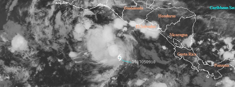
Featured image: Tropical Storm "Adrian" at 09:45 UTC on May 10, 2017. Credit: UW-CIMSS
Tropical Storm "Adrian" formed in the Northeast Pacific Ocean today as the first tropical cyclone of the 2017 Pacific Hurricane Season. Adrian is the earliest tropical cyclone to ever form during the satellite era. The previous record was held by Tropical Storm "Alma" which formed on May 14, 1990.
At 03:00 UTC on May 10, the center of Tropical Storm "Adrian" (01E) was located about 575 km (360 miles) SW of San Salvador, El Salvador and 810 km (500 miles) SSE of Salina Cruz, Mexico. The system is moving toward the west-northwest near 11 km/h (7 mph) and this general motion is expected for the next couple of days, NWS NHC said. Its estimated minimum central pressure is 1004 hPa.
At the time, Adrian's maximum sustained winds were near 65 km/h (40 mph) with higher gusts. Additional strengthening is expected during the next 48 hours, and Adrian is expected be near hurricane strength by late Thursday / early Friday, May 12.
Tropical-storm-force winds extend outward up to 55 km (35 miles).
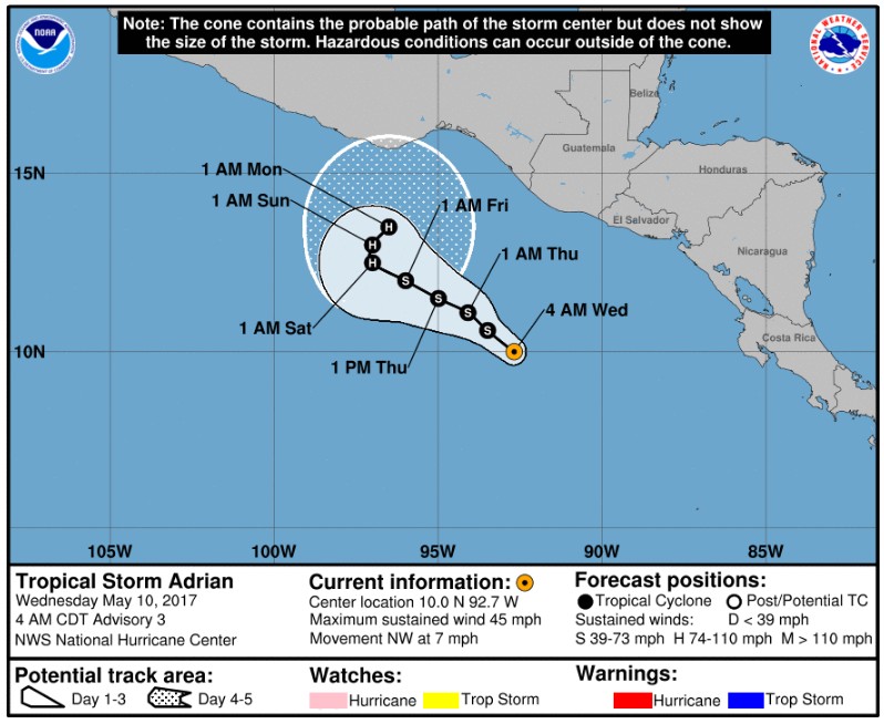
Tropical Cyclone "Adrian" forecast track by NWS NHC at 09:00 UTC on May 10, 2017
Adrian is moving slowly west-northwestward along the southern periphery of a deep-layer ridge located over the central and southwestern Gulf of Mexico. The global and regional models are fair agreement on this ridge pattern remaining basically static for the next 48-72 hours, so little change in the west-northwestward motion of the tropical storm is expected during that time.
By 72 hours and beyond, the ridge to the north of Adrian is forecast to gradually weaken and eventually break down by 120 hours as the large-scale, high-amplitude flow pattern across the United States weakens and shifts eastward. This pattern change is expected to result in weak southwesterly steering flow developing, causing the cyclone to slow down significantly and turn northeastward.
By 96-120 hours, increasing southerly to southwesterly vertical wind shear could disrupt the intensification process, but Adrian is expected to already be a hurricane by that time.
"It is interesting to note that the GFS is basically the only dynamical model that significantly intensifies Adrian. Both the HWRF and the ECMWF do not," NHC said at 09:00 UTC today. "In fact, the latest ECMWF weakens the cyclone to a broad area of low pressure within the next 5 days. Based on continuity, the fact that Adrian is moving over warm waters and the shear is low, gradual strengthening is still forecast."
The cyclone will most likely begin to meander well south of Mexico in 3 days.
I'm a dedicated researcher, journalist, and editor at The Watchers. With over 20 years of experience in the media industry, I specialize in hard science news, focusing on extreme weather, seismic and volcanic activity, space weather, and astronomy, including near-Earth objects and planetary defense strategies. You can reach me at teo /at/ watchers.news.
Commenting rules and guidelines
We value the thoughts and opinions of our readers and welcome healthy discussions on our website. In order to maintain a respectful and positive community, we ask that all commenters follow these rules.