
Severe weather hits Northwestern US, urban flooding, mudslides and power outages expected
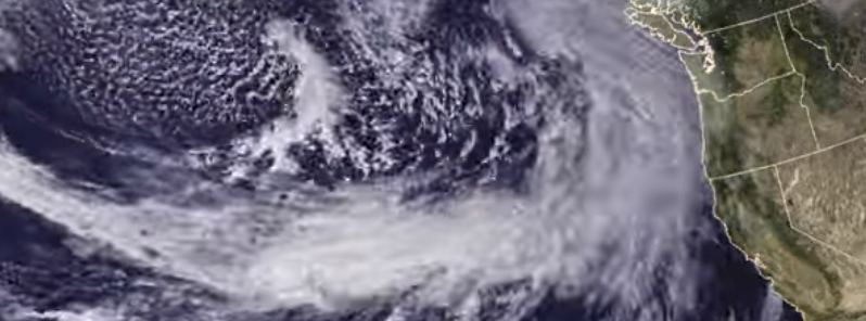
Featured image: The Geocolor Satellite imagery shows the development of a storm force low in the E Pacific. Image credit: NWS Ocean Prediction Center
The National Weather Service (NWS) has announced the heavy rainfall and strong winds are expected over the Pacific Northwest and northern California, as several low pressure systems set in. As one of the frontal systems moves across the northwestern US during the day, another system, comprising the remnants of Typhoon "Songda" is expected to lash the region as of tomorrow. Stormy weather will continue into early next week, as well. Urban flooding, mudslides, power outages, and traffic disruptions are expected across the affected regions.
Intense storm systems will continue to affect the West Coast throughout the weekend and heavy rains and strong winds are likely across the Pacific Northwest and northern California. One of the frontal systems is forecast to move inland and cause widespread rainstorms across the northwestern US during the day.
Read more: Tornadoes rip through Oregon Coast, major damage in Manzanita
As the storm system continues to progress into the Interior West on October 15, it will bring snowfall across the higher elevations of the northern Rockies.
Another system is forecast to move onshore on October 15, bringing another round of torrential downpours and strong winds. It will cause rainstorms, winds, and bring snow to higher elevations into the northern Rockies once again on the night of October 15 to 16 (local time).
The animation of the Geocolor Satellite imagery showing the development of a storm force low in the Eastern Pacific. This system starts off in the video to the south of the Aleutian Islands, and it develops as it moves SE into the eastern Pacific. It developed storm force winds in the strong cold advection south of the low center and also in the channeling flow between the front and terrain along the coast. Image credit: NWS Ocean Prediction Center
The first round of heavy rainfall and strong winds will continue moving across the Northwest into tonight and the major portion of rainfall will be focused along the Interstate 5 corridor from Seattle to Redding, California. Wind gusts between 64.4 and 96.6 km/h (40 and 60 mph) are expected across the affected areas while some coastal and mountainous regions will see gusts exceeding 128.7 km/h (80 mph). Some precipitation will reach all the way to San Francisco, bringing the first measurable rainfall since May 8 this year.
A second storm, brought on by the remnants of Supertyphoon "Songda" will affect the region in the period between October 15 and 16. The storm system will loose its typical tropical characteristics by the time it reaches the Pacific Northwest, although, according to Ale Sosnowski, an AccuWeather Senior Meteorologist, its impacts may still resemble those of a hurricane, as wind gusts between 120.7 and 160.9 km/h (75 and 100 mph) will hit several coastal regions. Power outages, tree and power damage are expected.
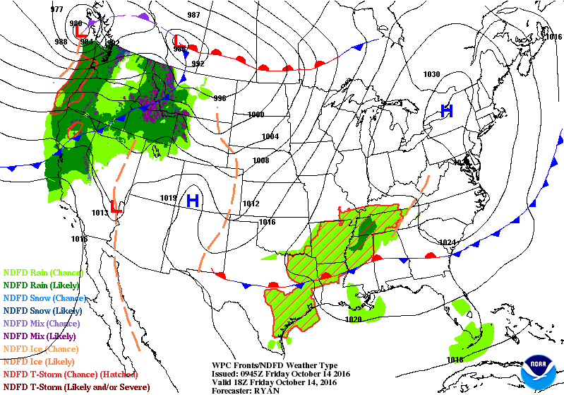
Short range weather forecast for October 14, 2016. Image credit: NWS/WPC
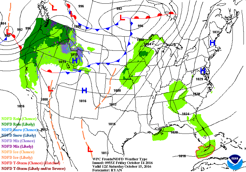
Short range weather forecast for October 15, 2016. Image credit: NWS/WPC
Short range weather forecast for October 14, 2016. Image credit: NWS/WPC
"The heaviest rain and highest winds will come onshore Saturday afternoon along the Washington, Oregon, and northern California coasts. A general 50.8 to 101.6 mm (2 to 4 inches) of rain will fall across the region, with higher amounts in the coastal ranges. Flooding will certainly be a concern after much of this same region is getting inundated with several inches of rain to end the workweek," said Dan Pydynowski, an AccuWeather Senior Meteorologist.
"Cumulative rainfall through Tuesday of next week will top 304.8 mm (12 inches) in some coastal areas with the potential for 457.2 mm (18 inches) in a few locations from northwestern California to the Olympic Peninsula of Washington," Sosnowski said.
At the same time, heavy snowfall will hit the highest mountainous regions of the Northwest.
A series of new storms, although not as intense, are expected to affect the northwestern US into the early coming week. The systems are expected to produce the biggest impact from southwestern British Columbia, western Washington, and Oregon, and into the northern California, as the storms start to travel onshore on October 18. Urban and coastal flooding, mudslides, damaged roads, power outages, infrastructural damage and traffic disruptions are expected.
Commenting rules and guidelines
We value the thoughts and opinions of our readers and welcome healthy discussions on our website. In order to maintain a respectful and positive community, we ask that all commenters follow these rules.