
Typhoon “Nida” shuts down Hong Kong, severe flooding possible across southern China

Image credit: CCTV
Typhoon "Nida" has made landfall in the southern Chinese city of Shenzhen, just north of Hong Kong late UTC Monday, August 1, 2016, with maximum sustained winds near 120 km/h (mph). This made Nida a Category 1 hurricane equivalent on the Saffir-Simpson Hurricane Wind Scale. Nida is a tropical storm now, moving over Guangdong province into Guangxi region. Chinese state media said Nida is set to be the strongest typhoon to hit the region since 1983, warning it could bring severe flooding.
Before hitting Hong Kong, Nida brought powerful winds and heavy rain to the Philippines over the weekend. Nida developed from Tropical Depression 06W on July 30. At the time, Nida, known in the Philippines as Carina, was intensifying and moving toward Northern Luzon.
After exiting the Philippine Area of Responsibility (PAR) on August 1, Nida no longer had any direct impact to the country. However, PAGASA still warned fisherfolk against rough to very rough seas over the northern seaboard of Luzon, the eastern seaboard of Central Luzon, and the western and southern seaboards of southern Luzon.
The Hong Kong Observatory (HKO) said Typhoon "Nida" made landfall near the Da Peng Peninsula between 19:00 and 20:00 UTC (03:00 – 04:00 HKT). The observatory said wind gusts up to 150 km/h (94 mph) were observed at Ngong Ping, west of Hong Kong.
Nearly 100 000 people were evacuated before the storm hit.
Hong Kong was shut down, while low-lying areas were put on flood alert. More than 150 flights have been canceled and 325 rescheduled, stranding hundreds of passengers. Ferry, tram, bus and other services were also suspended.
Three people were slightly injured, state media reported.
Nida is the first typhoon to track within 120 km (74 miles) of Hong Kong since Usagi on September 22, 2013.
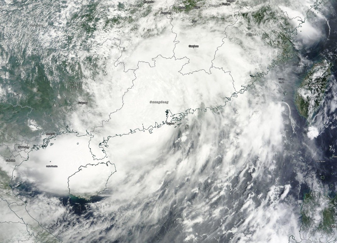
Typhoon "Nida" on August 2, 2016. Credit: NASA Terra/MODIS
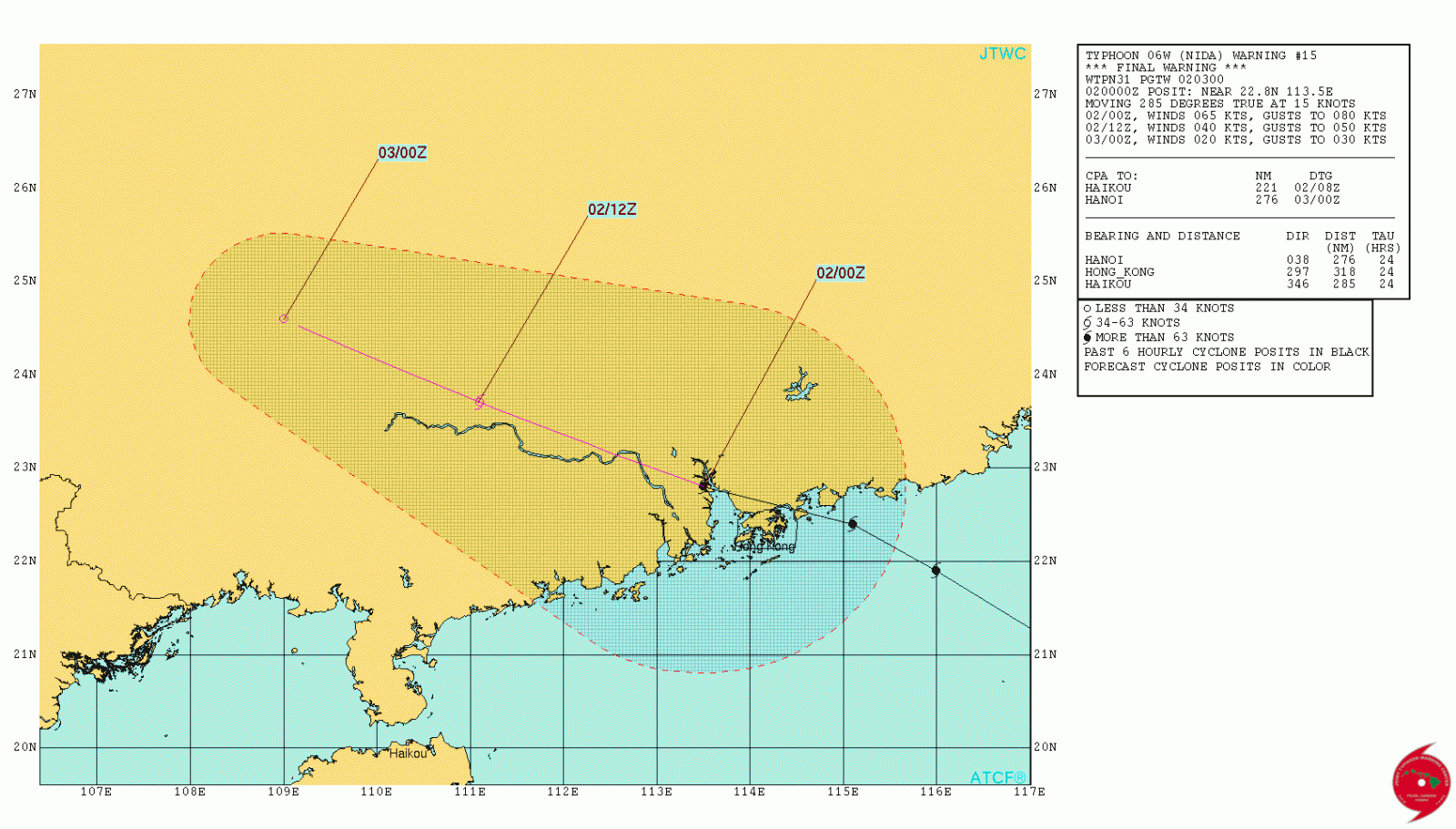
Tropical Storm "Nida" forecast track by JTWC on August 2, 2016
As of 09:00 UTC on August 2 (17:00 HKT), the HKO maintains Strong Wind Signal, No. 3. This means that winds with mean speeds of 41 to 62 km/h (25 to 38 mph) are expected. At the time, Tropical Storm "Nida" was estimated to be about 260 km (160 miles) northwest of Hong Kong and is forecast to move WNW at about 20 km/h (12 mph) across inland Guangdong, weakening gradually.
The Observatory said it will cancel all Tropical Cyclone Warning Signals shortly. However, occasional strong winds will still affect offshore areas and high ground at first. There are also swells.
Flights at Hong Kong International Airport may be affected by the weather, it said and warned the public to stay away from the shoreline, listen to radio, watch TV or browse the Hong Kong Observatory's website for information on the tropical cyclone.
As the storm continues to move across southern China, over the manufacturing center of Guangdong province and into Guangxi region, the city of Guangzhou in Guangdong issued a red alert, its highest weather warning, for the first time ever. The southern cities of Zhuhai and Shanwei are also on red alert, with transport, industry and public services largely put on stop.
National Commission for Disaster Reduction told residents living in storm's path to stay indoors and prepare three days' worth of food and other essentials.
According to Chinese state media, Nida is set to be the strongest typhoon to hit the region since 1983, warning it could bring severe flooding.
The Watchers team and our contributors bring the latest on extreme weather, earthquakes, volcanic eruptions, space weather, and all things science. We're all about making sense of the natural world and keeping you informed on what’s happening. Got a tip or a question? Hit us up using the form at newstips!
Commenting rules and guidelines
We value the thoughts and opinions of our readers and welcome healthy discussions on our website. In order to maintain a respectful and positive community, we ask that all commenters follow these rules.