
Violent Typhoon “Dujuan” slams into Taiwan, second landfall expected in China
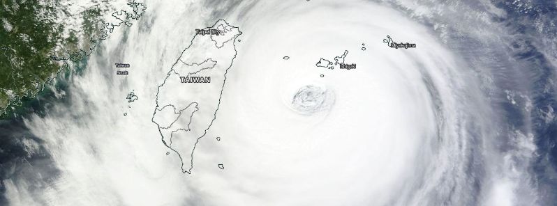
Featured image: Violent typhoon "Dujuan" approaching Taiwan, September 28, 2015. Image credit: NASA Terra/MODIS
Typhoon "Dujuan", known as Jenny in the Philippines, made landfall in Taiwan, on September 28, 2015, Japan Meteorological Agency (JMA) reported. The system slammed into the island with wind speeds over 200 km/h (124 mph) thus falling into a violent typhoon category. Violent winds and giant waves have already been reported across Taiwan, and further extreme weather conditions, including severe flooding and landslides are expected. Typhoon will continue marching toward China, where safety measurements have already taken place, while awaiting the second landfall.
The tropical system made landfall over Taiwan on September 28, 2015 slamming the island as a violent typhoon. At 10:45 UTC its center was located over Xincheng Township in Hualien County, Taiwan, according to JMA.
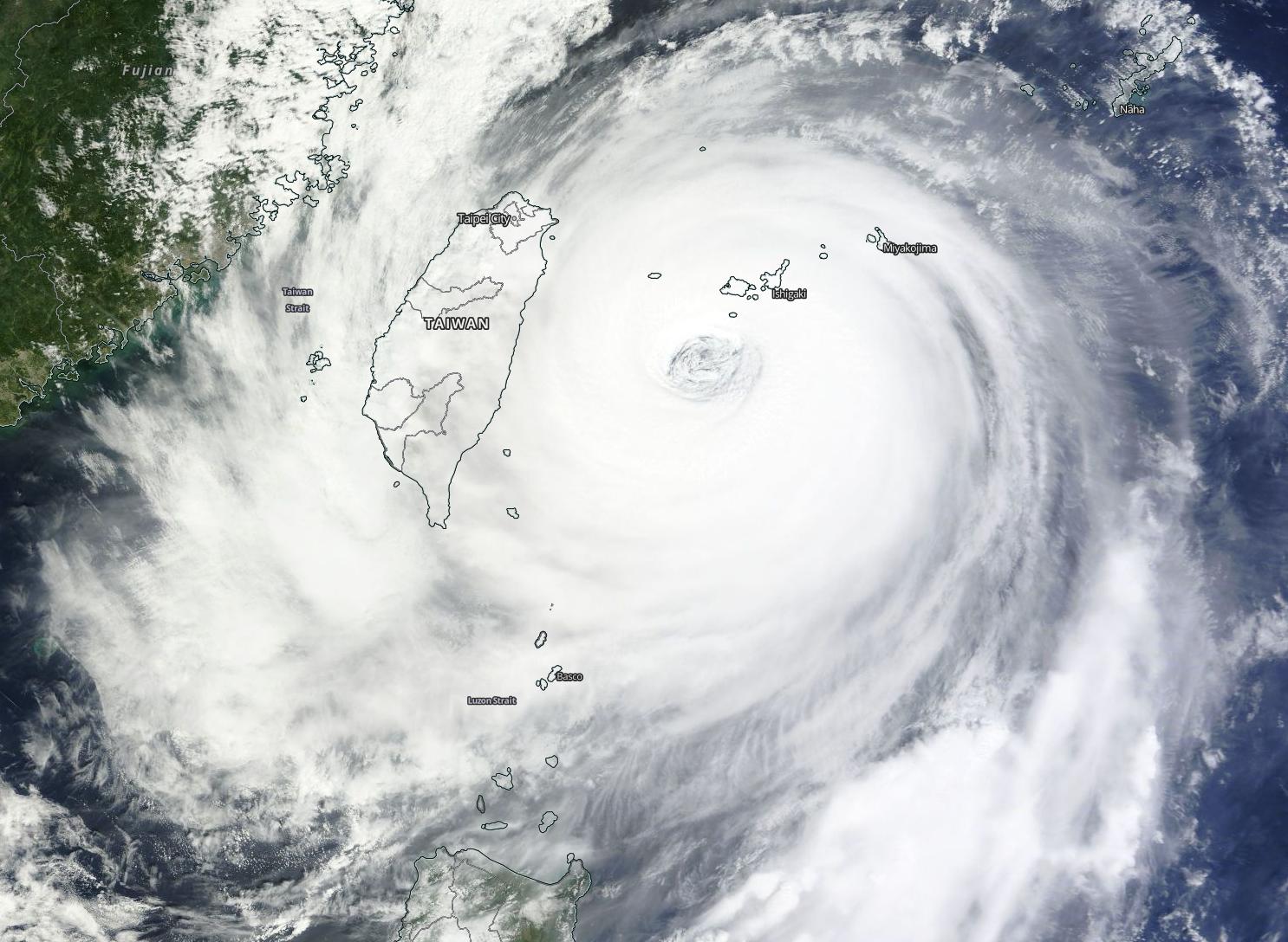
Violent Typhoon "Dujuan" approaching Taiwan, synoptic situation. Image credit: NASA Terra/MODIS
Typhoon "Dujuan" was packing maximum sustained winds of 222.2 km/h (138 mph) with wind gust speed reaching 268.5 km/h (166.8 mph) at 09:00 UTC, according to Joint Typhoon Warning Center (JTWC). Typhoon was moving westward at 30 km/h (18.6 mph) and its central pressure was estimated at 940 hPa.
James Reynolds of Earth Uncut TV, reported huge waves and extremely violent winds over Suao, Taiwan, as the system was approaching the island.
Video credit: WestPacWx
Almost 609.6 mm (2 feet) of rainfall has been reported in the mountain regions of northern Taiwan so far. Violent winds, flooding and landslides are expected across the affected areas, as the typhoon passes over the country.
The eye of Typhoon #Dujuan has made landfall over northern Taiwan pic.twitter.com/jJJu5cc1Tt
— Met Office Storms (@metofficestorms) September 28, 2015
Over 3 000 people were evacuated from Wulai district in northern Taiwan, as of September 28, media reports. More than 3 500 households have been cut off their power supplies so far, according to National authorities. Emergency Response Centers have been set up across the north and east areas of the country.
Schools and offices will be closed as of September 28 in Keelung, Taipei City, Taoyan, Yilan, Hsinchu County, Miaoli County, Taichung County and Nantou County.
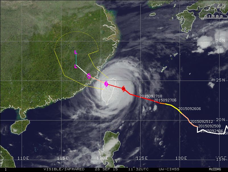
Violent Typhoon "Dujuan" track and forecast for the next 48 hours. Image credit: UW-CIMSS
The typhoon is forecasted to move over the eastern China Sea and make a second landfall in eastern Fujian province on September 29. Storm surge of up to 1.82 meters (6 feet) is expected to affect the areas of Putian city, in the early morning on September 29 (UTC).
An Orange Warning for Typhoon and a Yellow Warning for Rainstorm was issued on September 28 by the Chinese Meteorological Administration (CMA) for eastern Zhejiang, central-eastern Fujian and Taiwan.
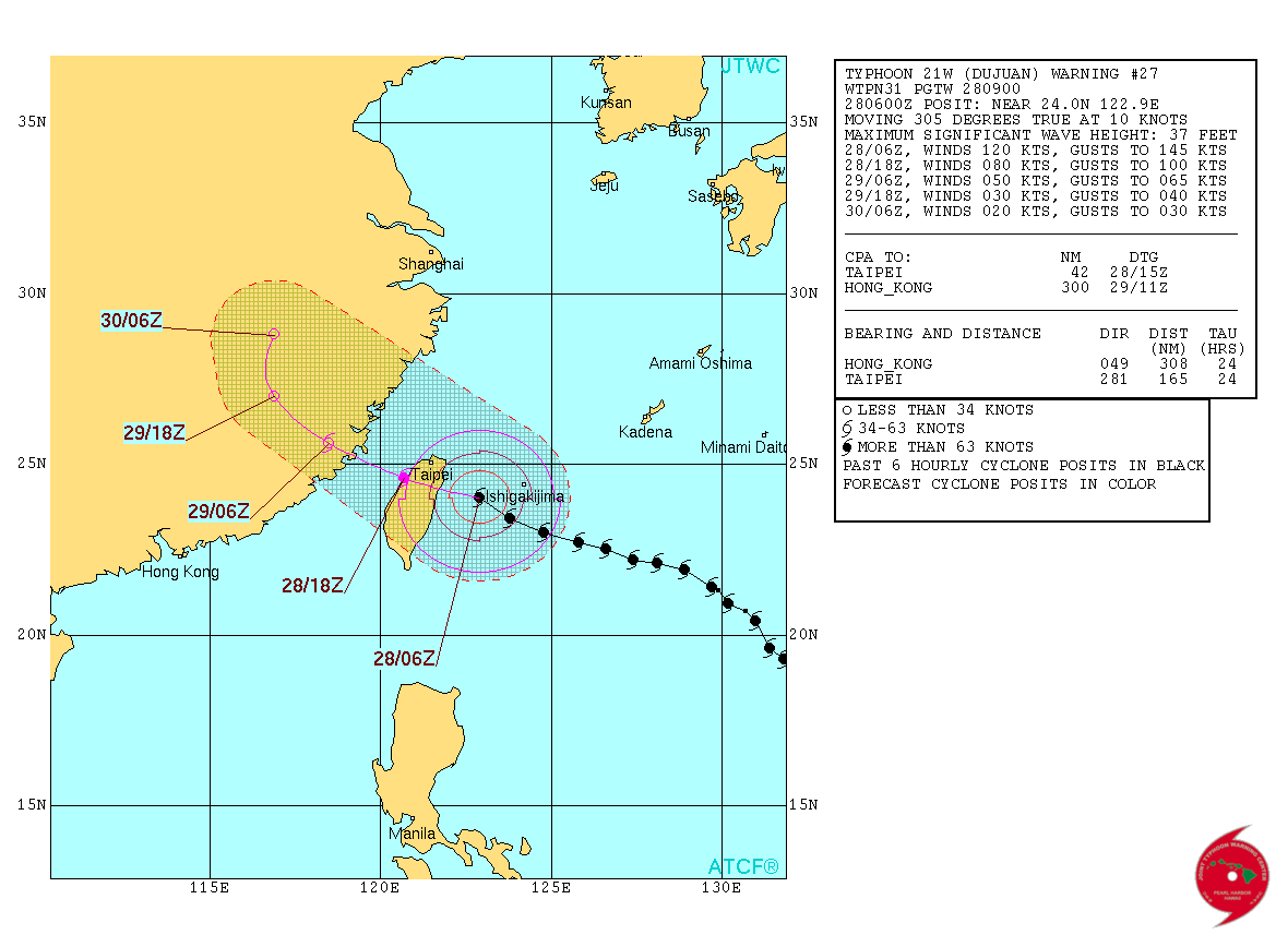
Violent Typhoon "Dujuan" forecast track over the next 48 hours. Image credit: JTWC
At the same time, Central Weather Bureau of Taiwan issued a Typhoon Warning and an Advisory for heavy to extremely heavy rain and strong winds for Taiwan.
JMA issued a Red Warning as heavy rainfall, floods, huge waves and storm surge was expected to hit Yaeyama, Miyako and Okinawa islands in the Okinawa prefecture. So far, almost no damage has been reported in Japan, despite an amazing wind speed of 291 km/h (181 mph) recorded on Yonaguni island, which set the record as the fourth strongest wind ever reported in the country, Robert Speta reports.
Monstrous waves crashing into small section of Suao port in #Taiwan as #typhoon #Dujuan nears pic.twitter.com/Xu63505moH
— James Reynolds (@EarthUncutTV) September 28, 2015
Over the next 36 hours Typhoon "Dujuan" is expected to continue traveling west-northwestward, prior to deflecting northward in response to an approaching mid-latitude trough over eastern China.
In the next 6 hours the system will gradually weaken due to land interaction with Taiwan and China, and cooling sea surface temperatures in the Taiwan Strait. Over the next two days, JTWC forecasts the violent typhoon's strength will reduce to a tropical disturbance.
Commenting rules and guidelines
We value the thoughts and opinions of our readers and welcome healthy discussions on our website. In order to maintain a respectful and positive community, we ask that all commenters follow these rules.