
Tropical Cyclone “Quang” forms in the Southern Indian Ocean, heading toward Australia
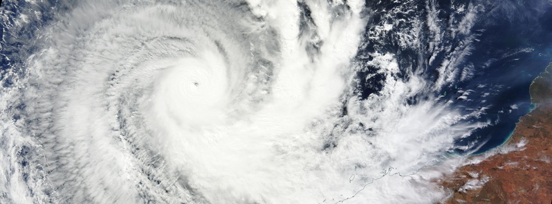
Featured image: Tropical Cyclone "Quang" on April 30, 2015. Image credit: NASA Terra/MODIS.
The tropical low pressure area formerly known by JTWC as System 98S has organized and developed on April 29, 2015 into Tropical Cyclone "Quang" in the Southern Indian Ocean. Quang is now a major, Category IV, cyclone which is expected to significantly weaken on its way toward landfall in Western Australia.
According to the JTWC, Quang had maximum sustained winds of 212 km/h (132 mph), and wind gusts to 259 km/h (161 mph) at 06:00 UTC today. This makes it a Category IV hurricane equivalent on the Saffir-Simpson Hurricane Wind Scale.
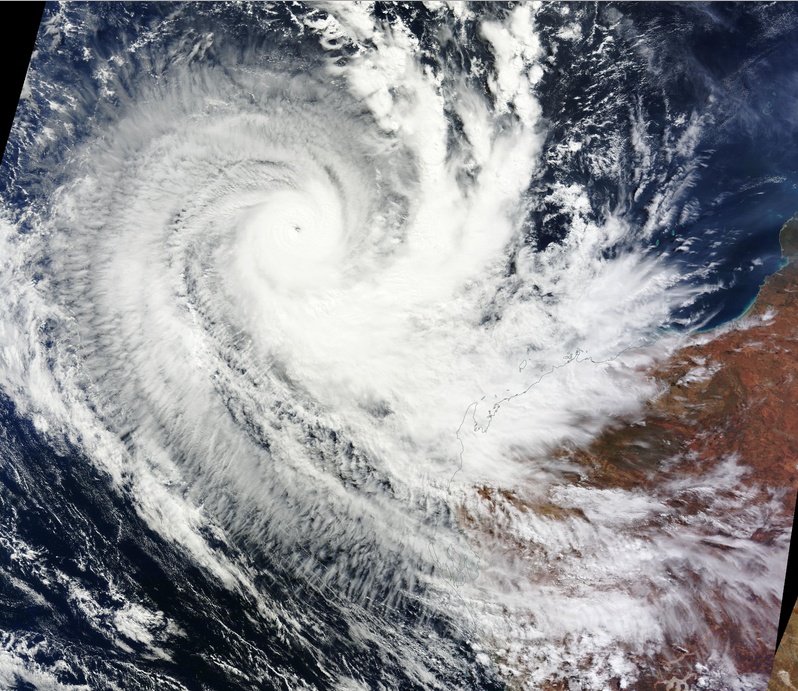
Tropical Cyclone "Quang" on April 30, 2015. Image credit: NASA Terra/MODIS.
At the same time, Australian Bureau of Meteorology (BOM) estimated sustained winds near the center of 195 km/h (121 mph) with wind gusts to 270 km/h (167 mph). Quang was estimated to be 650 km (403 miles) northwest of Exmouth and 890 km (553 miles) north northwest of Carnarvon moving south southeast at 15 km/h (9.3 mph).
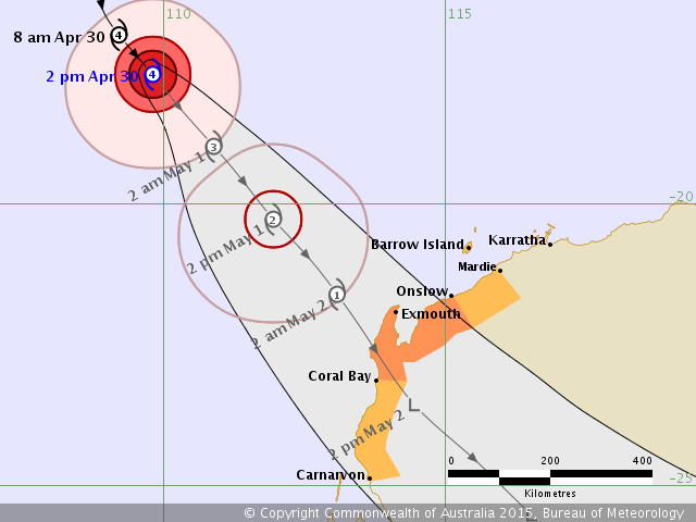
Tropical Cyclone "Quang" forecast track by BOM on April 30, 2015.
Severe Tropical Cyclone Quang will move towards the northwest of the state during the next 36 hours, BOM said. Quang is likely to weaken in an increasingly unfavorable environment, and is forecast to weaken below cyclone intensity Saturday morning (local time).
Windy conditions are expected to develop about the far northwest of the state on Friday, with gales possible near the NW Cape from late Friday morning if the system moves faster than forecast. Gales could extend throughout the coastal areas between Onslow and Coral Bay later on Friday, and reach remaining areas between Mardie and Carnarvon Saturday morning.
Heavy rain may develop over parts of the Gascoyne and western Pilbara over the weekend as the remnants of Quang move through.
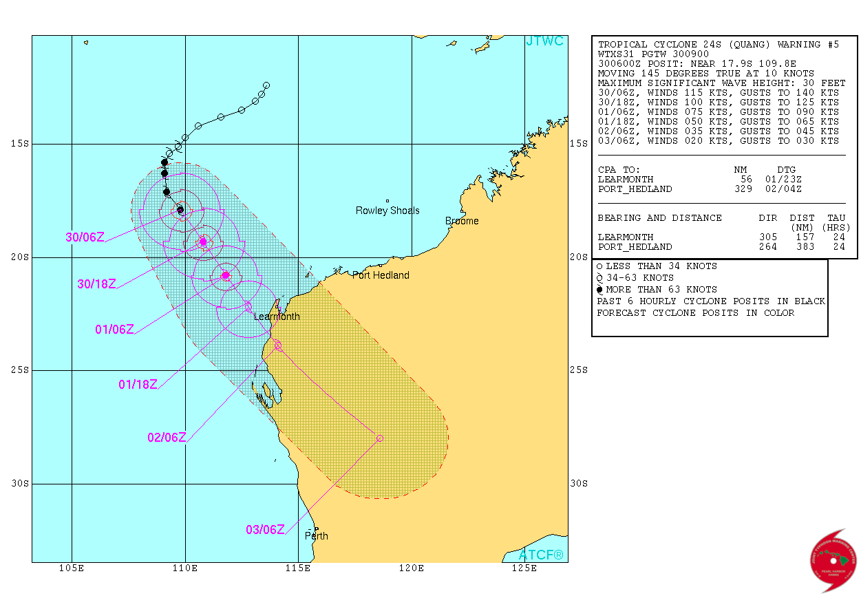
Tropical Cyclone "Quang" forecast track by JTWC on April 30, 2015.
At 09:00 UTC today, JTWC estimated that the system was located approximately 663 km (411 miles) northwest of Learmonth and has tracked southeastward at 18.5 km/h (11.5 miles) over the past six hours. Animated multispectral satellite imagery depicts deep convective spiral banding wrapping into an 14.8 km (9.2 miles) cloud filled eye that has become elongated due to strong upper level northwesterly winds.
Quang is tracking along the western periphery of the deep layered sub-tropical ridge to the northeast. As it tracks tracks SE, increased vertical wind sheer and convergence aloft will combine to rapidly weaken the system. After 36 hours, the system will further weaken due to frictional effects of land interaction as it makes landfall west of Learmonth.
Satellite animations
- Storm-Centered Infrared (MTSAT; NOAA/SSD)
- Storm-Centered Infrared (Aviation Color Enhancement) (MTSAT; NOAA/SSD)
- Storm-Centered Water Vapor (MTSAT; NOAA/SSD)
- Storm-Centered Visible (MTSAT; NOAA/SSD)
- Storm-Centered Visible (Colorized) (MTSAT; NOAA/SSD)
- Storm-Centered Infrared (MTSAT; CIMSS)
- Storm-Centered Enhanced Infrared (MTSAT; CIMSS)
- Storm-Centered Water Vapor (MTSAT; CIMSS)
- Storm-Centered Visible (MTSAT; CIMSS)
- MTSAT Infrared (MTSAT; CIMSS)
- MTSAT Infrared (Color Background) (MTSAT; CIMSS)
- MTSAT Infrared (NHC Color Enhancement (MTSAT; CIMSS)
- MTSAT Water Vapor (MTSAT; CIMSS)
- MTSAT Water Vapor (Color Background) (MTSAT; CIMSS)
- Meteosat 7 Infrared (Meteosat 7; CIMSS)
- Meteosat 7 Infrared (Color Background) (Meteosat 7; CIMSS)
- Meteosat 7 Infrared (NHC Color Enhancement) (Meteosat 7; CIMSS)
- Meteosat 7 Water Vapor (Meteosat 7; CIMSS)
- Meteosat 7 Water Vapor (Color Background) (Meteosat 7; CIMSS)
I'm a dedicated researcher, journalist, and editor at The Watchers. With over 20 years of experience in the media industry, I specialize in hard science news, focusing on extreme weather, seismic and volcanic activity, space weather, and astronomy, including near-Earth objects and planetary defense strategies. You can reach me at teo /at/ watchers.news.
Commenting rules and guidelines
We value the thoughts and opinions of our readers and welcome healthy discussions on our website. In order to maintain a respectful and positive community, we ask that all commenters follow these rules.