
Tropical Cyclone “Solo” forms in the Coral Sea, SW Pacific Ocean
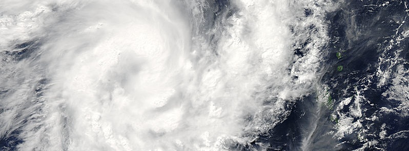
Featured image: Tropical Cylcone "Solo" on April 10, 2015. Image credit: NASA Aqua/MODIS.
Tropical Cyclone "Solo" formed in the Coral Sea, Southwestern Pacific Ocean on April 10, 2015 triggering tropical disturbance watch for Solomon Islands provinces of Rennell and Bellona, Temotu, Makira, Central, Guadalcanal and Malaita.
Solo is expected to intensify and move toward New Caledonia representing a direct threat, with a closest approach to Belepe late Sunday, April 12 (local time). Significant intensification of rain and wind is expected.
The center of the storm was circled by powerful thunderstorms, and a band of thunderstorms extended from the southeast out from the storm to the northeast, as visible on Aqua MODIS imagery taken on April 10:

On April 10 at 02:45 UTC, the MODIS instrument aboard NASA's Aqua satellite captured this visible image of Tropical Cyclone "Solo" in the Southwestern Pacific Ocean. Image Credit: NASA Goddard MODIS Rapid Response Team.
The Atmospheric Infrared Sounder (AIRS) instrument aboard NASA's Aqua satellite saw cloud top temperatures as cold as 210 kelvin (-81.6C/-63.1F) in powerful thunderstorms circling Solo's center and in bands of thunderstorms east and northwest of the center. Previous research has shown that thunderstorms that high (and that cold) have the ability to generate heavy rainfall, NASA's Goddard Space Flight Center noted.
At 15:00 UTC today, Solo's maximum sustained winds had already reached 83.3 km/h (51.7 mph). It was centered about 896 km (557 miles) northwest of Noumea, New Caledonia moving to the south at 24 km/h (15 mph).

Tropical Cyclone "Solo" forecast track by JTWC on April 10, 2015.
Solo's winds are expected to peak near 102 km/h (63.2 mph) on April 11, before weakening as a result of increasing vertical wind shear when it interacts with a deep mid-latitude trough (elongated area) of low pressure and cooler sea surface temperatures.
JTWC expect those two factors to dissipate the storm by April 14.
Satellite animations
- Storm-Centered Infrared (MTSAT; NOAA/SSD)
- Storm-Centered Infrared (Aviation Color Enhancement) (MTSAT; NOAA/SSD)
- Storm-Centered Water Vapor (MTSAT; NOAA/SSD)
- Storm-Centered Visible (MTSAT; NOAA/SSD)
- Storm-Centered Visible (Colorized) (MTSAT; NOAA/SSD)
- Storm-Centered Infrared (Meteosat 7; CIMSS)
- Storm-Centered Enhanced Infrared (Meteosat 7; CIMSS)
- Storm-Centered Water Vapor (Meteosat 7; CIMSS)
- Storm-Centered Visible (Meteosat 7; CIMSS)
- Southwest Pacific Infrared (MTSAT; NOAA)
- Southwest Pacific Enhanced Infrared (MTSAT; NOAA)
- Southwest Pacific Water Vapor (MTSAT; NOAA)

Teo Blašković founded The Watchers in 2011 and edited it until 2026, covering seismic and volcanic activity, extreme weather, space weather and near-Earth objects. Articles on this page are his archive.
Published in the last 24 hours
- Cyclone Akvan weakens after landfall near Gopalpur; more than 300 000 evacuated in Odisha, India
- Male toads abandoned a pond in Italy five days before a deadly 2009 earthquake, while a scientist was counting them Epicenter
- An asteroid was spotted 19 hours before it exploded over Sudan in 2008, and students picked its pieces off the desert Epicenter
- A wave up to 3 m (10 feet) high rose out of Lake Michigan on a sunny June morning in 1954 and swept fishermen off Chicago’s piers, and when a second came 10 days later, warnings had cleared the shore Epicenter



