
Preliminary map of Rosetta’s target – comet 67P/Churyumov-Gerasimenko
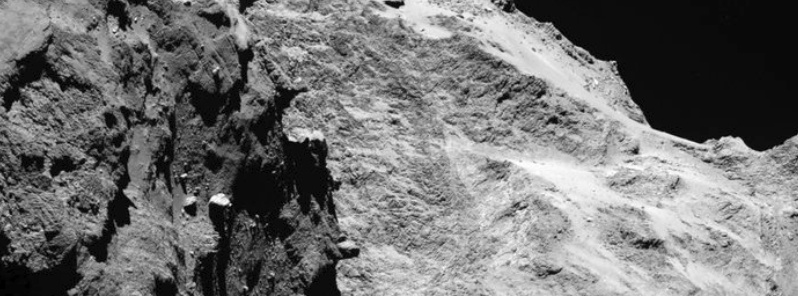
Image credit: ESA/Rosetta/MPS for OSIRIS Team MPS/UPD/LAM/IAA/SSO/INTA/UPM/DASP/IDA
The preliminary map of comet 67P/Churyumov-Gerasimenko and new high resolution images from OSIRIS instrument were released at special session at EPSC yesterday. This is the first time a cometary surface was seen in such detail. In some of the images, one pixel corresponds to 75 centimeters scale on the nucleus
This preliminary analysis provides the basis for a detailed scientific description of the comet’s surface, but a substantial amount of work involving more detailed OSIRIS images and data from other Rosetta instruments lies ahead to determine what each region represents in terms of their composition and evolution. One recent image from the OSIRIS narrow-angle camera is also shown here.
Comet's surface was divided into a number of different regions based on their morphology, revealing a unique, multifaceted world.
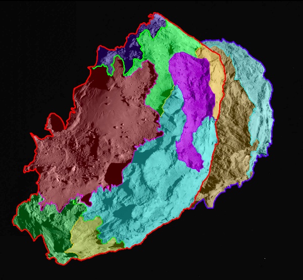
Several morphologically different regions are indicated in this preliminary map, which is oriented with the comet’s ‘body’ in the foreground and the ‘head’ in the background.
Credits: ESA/Rosetta/MPS for OSIRIS Team MPS/UPD/LAM/IAA/SSO/INTA/UPM/DASP/IDA
With various areas dominated by cliffs, depressions, craters, boulders or even parallel grooves, 67P/C-G displays a multitude of different terrains. Some areas even appear to have been shaped by the comet’s activity.
As both 67P/C-G and Rosetta travel closer to the Sun over the next months, the OSIRIS team will monitor the surface looking for changes. While the scientists do not expect the borderlines of the comet’s regions to vary dramatically during this one passage around the Sun, more subtle transformations of the surface may nevertheless help to explain how cometary activity created such a breath-taking world.
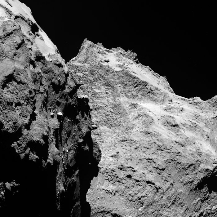
Jagged cliffs and prominent boulders are visible in this image taken by OSIRIS on September 5, 2014 from a distance of 62 kilometres from comet 67P/Churyumov-Gerasimenko. The left part of the image shows a side view of the comet’s 'body', while the right is the back of its 'head'. One pixel corresponds to 1.1 metres.
Credits: ESA/Rosetta/MPS for OSIRIS Team MPS/UPD/LAM/IAA/SSO/INTA/UPM/DASP/IDA
Next weekend, on September 13 and 14, 2014, the maps will play a key role as Rosetta’s Lander Team and the Rosetta orbiter scientists gather at CNES, Toulouse to determine a primary and backup landing site from the earlier pre-selection of five candidates.
I'm a dedicated researcher, journalist, and editor at The Watchers. With over 20 years of experience in the media industry, I specialize in hard science news, focusing on extreme weather, seismic and volcanic activity, space weather, and astronomy, including near-Earth objects and planetary defense strategies. You can reach me at teo /at/ watchers.news.
I hope ESA will publish a 3d model of 67P for 3d printing 🙂