
Strong, shallow and extremely dangerous earthquake M6.5 struck China
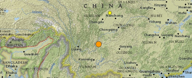
Image credit: USGS
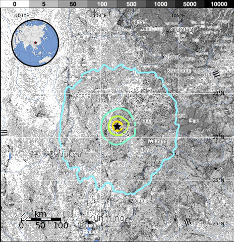
A strong, shallow and extremely dangerous earthquake with recorded magnitude of 6.5 (CENC – China Earthquake Networks Center) struck Ludian county of Yunnan province, China, on August 3, 2014, at 08:30 UTC (16:30 local time). CENC is reporting depth of 10 km. USGS is reporting M6.1 at depth of 10 km.
The shaking lasted for about 30 seconds.
According to USGS, epicenter was located 11 km (7 miles) WNW of Wenping, 29 km (18 miles) WSW of Zhaotong, 91 km (57 miles) WNW of Weining and 135 km (84 miles) ESE of Xichang, China
There are 6 661 549 people living within 100 km radius.
This earthquake had mainly horizontal movement, the most dangerous type of earthquakes possible.
USGS issued yellow alert level for shaking-related fatalities. Some casualties are possible.
Red alert level was issued for economic losses. Extensive damage is probable and the disaster is likely widespread. Estimated economic losses are less than 1% of GDP of China. Past events with this alert level have required a national or international level response.
Overall, the population in this region resides in structures that are highly vulnerable to earthquake shaking, though some resistant structures exist. The predominant vulnerable building types are unreinforced brick masonry and ductile reinforced concrete frame construction.
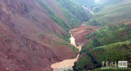
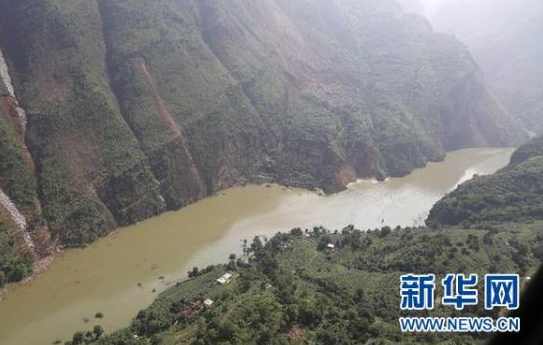
Recent earthquakes in this area have caused secondary hazards such as landslides that might have contributed to losses.
The road from Zhaotong leading to the epicenter is blocked by numerous landslides. Government agencies are rushing to the site to make them free but due to the aftershocks, this is an extremely dangerous task. Normally the distance to the epicenter is only 1 hour driving from the County capital Zhaotong.
Bad weather is expected (torrential rains and a lot of thunderstorms) in the greater epicenter area. This is additional bad news as people have to stay outside for a number of days and as the risk for landslides is extremely high. Landslides are the second major indirect fatality cause during and after earthquakes. (ER)
This is the most deadly earthquake in 2014 so far.
In 1974, a 7.1-magnitude earthquake in the same place caused about 1 500 deaths.
Population exposure
Population per ˜1 sq. km. from LandScan
Selected cities exposed
from GeoNames Database of Cities with 1,000 or more residents.
| MMI | City | Population |
|---|---|---|
| VII | Wenping | <1k |
| VI | Zhaotong | 109k |
| IV | Tiandiba | <1k |
| IV | Xinhua | <1k |
| IV | Weining | 57k |
| IV | Temuli | <1k |
| III | Dadukou | 462k |
| III | Kunming | 1,024k |
| III | Zigong | 690k |
| III | Anshun | 352k |
| III | Neijiang | 547k |
(k = x1,000)
#Earthquake #China – The first pictures are coming in and they look grim – http://t.co/7Wt7Q61vrX pic.twitter.com/R890oDB7R2
— Earthquake Report M6 (@Quake_Tracker6) August 3, 2014
Strong #earthquake in Yunnan, #China kills at least 150 http://t.co/rXOCm93bGI PHOTOS: http://t.co/B6Ip8zCB8D pic.twitter.com/l7AuXuIeTk
— Yahoo Canada News (@YahooCanadaNews) August 3, 2014
South-west #China quake: Residents frantically search for survivors beneath toppled buildings http://t.co/AezmZBcTTx pic.twitter.com/S8asfsNh18
— ST Foreign Desk (@STForeignDesk) August 3, 2014
Updates:
August 3
Communication networks (fixed and mobile) with the epicenter area are down = no reliable information from the epicenter area. The Contingency alert level has been raised to III confirming the extreme impact of this earthquake. Provincial Civil Affairs Department is sending 2000 tents, 500 colored cloths, 3 000 sets of folding beds, 3 000 quilts and 3 000 cotton-padded clothes + other relief supplies to Ludian County.
11:25 UTC: 26 people have been killed in Qiaojia County, most of them children who were buried below a school that collapsed during the shaking of the earthquake. Very sad news! The number of injured stays at 79 at the moment but will be increasing too.
At least 150 people were killed. More than 180 people are missing and more than 1 300 were injured, state-run Xinhua News Agency reported, citing local authorities.
August 4, 06:50 UTC: The death toll increased further to 391 (398) people, 3 are still missing. 2 226 people have been or are being treated for injuries. 12 000 houses have collapsed and at least 100 000 are damaged to various extend. (ER)
An aerial view of the town worst hit by a 6.5-magnitude earthquake in southwest China's Yunnan Province has shown the extent of the devastation and it provided valuable information for the ongoing rescue operation. The footage of Longtoushan Town was shot on Monday morning by a drone operated by the communication detachment of an army reserve division in Yunnan.
Kraal river landslide lake
A dangerous situation is developing upstream the Kraal river where a landslide lake is being formed. The only barrier for the lake is the landslide material. The population downstream the lake has been evacuated by the army and rescue personnel. Due to the torrential rain in the mountains, the lake level could rise strongly. The water is rising 1.1 m per hour.
August 06, 05:49 UTC: At least 589 people had been confirmed killed as of Wednesday morning, China's ministry of civil affairs said, marking a sharp increase in the death toll. The ministry added that 2 401 people were injured and 230 000 had been evacuated, while more than 80 000 homes had fully or partially collapsed.
I'm a dedicated researcher, journalist, and editor at The Watchers. With over 20 years of experience in the media industry, I specialize in hard science news, focusing on extreme weather, seismic and volcanic activity, space weather, and astronomy, including near-Earth objects and planetary defense strategies. You can reach me at teo /at/ watchers.news.
Commenting rules and guidelines
We value the thoughts and opinions of our readers and welcome healthy discussions on our website. In order to maintain a respectful and positive community, we ask that all commenters follow these rules.