
Long duration M1.4 solar flare erupted near the northeast limb
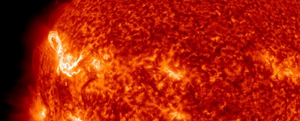
Image credit: NASA SDO AIA 304 on July 1, 2014, at 11:41 UTC.
A long duration solar flare measuring M1.4 at its peak time erupted on July 1, 2014, at 11:23 UTC. The source of this event was AR 2106 ('beta') located near the northeast limb.
The event started at 11:05, peaked at 11:23 and ended at 11:59 UTC. Coronal Mass Ejection (CME) from this event should not be Earth directed.
Forecasters estimate 40% chance of M-class, and 5% chance of X-class solar flares over the next two days.


M1.4 solar flare on July 1, 2014 @ 11:41 UTC. Image credit: NASA SDO / AIA 304
Sunspots
There are currently 8 numbered sunspot regions on the Earth side of the Sun. Two old and huge active regions AR 2080 and AR 2085 are making another rotation over the Earth side of the Sun. They both emerged over the weekend and are now numbered 2104 and 2107, respectively. They both remain of greatest interest and risk for significant flares.
AR 2104 has developed a 'beta-gamma-delta' magnetic field configuration and harbors energy for major solar flares.

Sunspots on July 1, 2014. Image credit: NASA SDO / HMI
2096 – Beta
2097 – Alpha
2100 – Beta
2102 – Beta
2104 – Beta-Gamma-Delta (ex 2080)
2105 – Beta
2106 – Beta
2107 – Beta-Gamma (ex 2085)

Teo Blašković founded The Watchers in 2011 and edited it until 2026, covering seismic and volcanic activity, extreme weather, space weather and near-Earth objects. Articles on this page are his archive.
Earlier reporting
Nothing on Watchers was published in the last 24 hours. These are older articles.
- On October 22, 2017, a single flash of lightning stretched 515 miles from eastern Texas to near Kansas City, a distance that takes eight hours to drive, and nobody realized how far it had gone until scientists went back through the satellite data years later Epicenter
- CPC posts a slight risk of heavy rain from the Gulf Coast to the Northeast urban corridor November 25-29, and a moderate risk of West Coast wind and Sierra snow on November 25
- Florida's east coast faces a moderate flash flood risk Wednesday through Friday, with 4 to 8 inches of rain forecast and the St. Johns River near Cocoa already in major flood at 17.13 feet
- Cyclone Akvan to make landfall between Nellore and Visakhapatnam around noon on November 20, IMD forecasts 120-130 km/h winds gusting to 145
