
Increasing explosive activity at Ubinas volcano prompts evacuation preparations, Peru
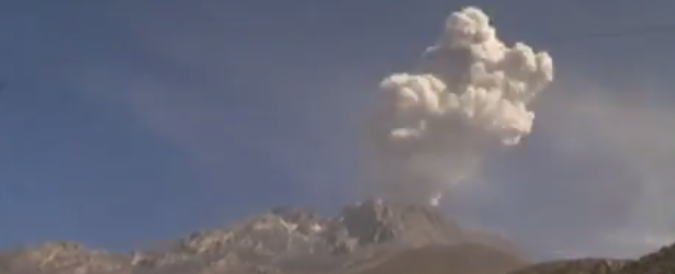
Image credit: IGP
Activity at Ubinas volcano significantly increased over the last two weeks. Prime minister René Cornejo said evacuation preparations for immediate surroundings of the volcano are now in progress.
IGP's Observatorio Volcanologico de Arequipa (IGP-OVA) reported that during March 29 – April 2 seismicity at Ubinas increased significantly. The increase began on March 29 with energetic tremor (indicating magma ascent and degassing) and small explosions.
On April 2 harmonic tremor was detected. Gas-and-ash plumes rose 0.9 – 2.2 km above the crater and drifted SE and E. Minor ashfall was reported in Tonohaya (7 km SSE), San Miguel, and Ubinas (6.5 km SSE). Based on webcam views, the Buenos Aires VAAC reported that on April 3 gas-and-steam plumes possibly containing ash rose 6.1 – 7.3 km (20,000-24,000 ft) a.s.l. and dissipated around the crater.
IGP-OVA noted that on April 4 there were 23 explosions detected; ash plumes drifted S and SE. During April 5 – 7 explosions generated ash plumes that rose as high as 2 km and drifted S and SW. During April 7 – 8 explosions also ejected incandescent fragments, up to 20 cm in diameter, no more than 1 km away. Ash plumes rose as high as 3 km.
Explosions on April 9 produced ash plumes that reached height of up to 3 km.
Time-lapse video of April 11th activity:
Video courtesy of Volcano Discovery
For the moment, the Geophysical Institute of Peru (IGP) notes that the nearest village, Querapi, located 4 km from the volcano, is not in danger, and that the eruption so far is still considerably smaller than the last one in 2006. IGP on the other hand cannot rule out the possibility that activity further increases, Volcano Discovery reports.
The increased volcanic activity forced the prime minister, René Cornejo, to announce the state of emergency for the immediate surroundings of the volcano, and that preparations are being made to evacuate Annex Querapi. Medical teams, supplies of food, plus 30 000 dust masks and 10 000 safety goggles were sent to Querapi.
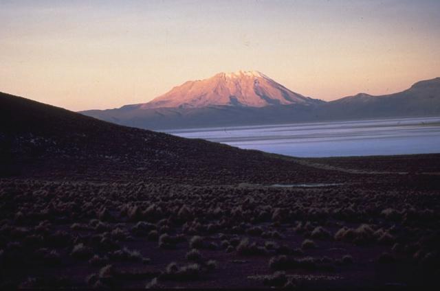
Ubinas volcano, Peru. Author: Norm Banks (U.S. Geological Survey) – 1988
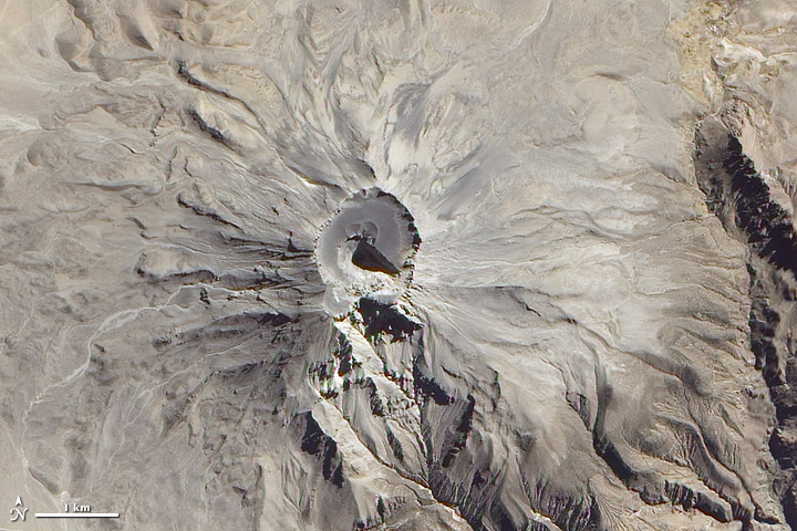
Image credit: NASA / Earth Observatory (ALI). Date acquired February 6, 2011.
Geologic summary
A small, 1.4-km-wide caldera cuts the top of Ubinas, Peru's most active volcano, giving it a truncated appearance. Ubinas is the northernmost of three young volcanoes located along a regional structural lineament about 50 km behind the main volcanic front of Perú. The growth and destruction of Ubinas I volcano was followed by construction of Ubinas II volcano beginning in the mid-Pleistocene. The upper slopes of the andesitic-to-rhyolitic Ubinas II stratovolcano are composed primarily of andesitic and trachyandesitic lava flows and steepen to nearly 45 degrees.
The steep-walled, 150-m-deep summit caldera contains an ash cone with a 500-m-wide funnel-shaped vent that is 200 m deep. Debris-avalanche deposits from the collapse of the SE flank of Ubinas about 3700 years ago extend 10 km from the volcano. Widespread plinian pumice-fall deposits from Ubinas include one of Holocene age about 1000 years ago. Holocene lava flows are visible on the volcano's flanks, but historical activity, documented since the 16th century, has consisted of intermittent minor-to-moderate explosive eruptions. (GVP)
I'm a dedicated researcher, journalist, and editor at The Watchers. With over 20 years of experience in the media industry, I specialize in hard science news, focusing on extreme weather, seismic and volcanic activity, space weather, and astronomy, including near-Earth objects and planetary defense strategies. You can reach me at teo /at/ watchers.news.
Commenting rules and guidelines
We value the thoughts and opinions of our readers and welcome healthy discussions on our website. In order to maintain a respectful and positive community, we ask that all commenters follow these rules.