
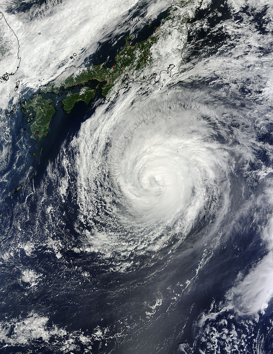
Tropical Storm Pabuk flooded Philippines immediately after Usagi
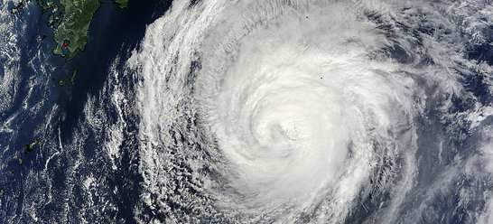
Image credit: NASA Goddard MODIS Rapid Response Team
Tropical Depression 19-W strengthened into Tropical Storm Pabuk on September 22, 2013 and lashed the northern Philippines immediately after Super-Typhoon Usagi which is considered to be the strongest typhoon to hit the western Pacific this year.
At least 30 people in the northern Philippines have been killed in resulting floods and landslides. So far, 87 000 people have been displaced and flooding continues due to ongoing monsoon rains in the northern provinces of Bataan and Laguna.
On September 23, TS Pabuk strengthened into Category 1 typhoon packing wind speeds of more than 121 km/h (75 mph).
According to latest JTWC warning issued at 15:00 UTC Typhoon Pabuk was positioned near 30.8N 140.9E and located approximately 307 NM (568.5 km) south of Yokosuka, Japan. It has tracked northeastward at 13 knots/24 km/h/14.9 mph over the past six hours. Maximum significant wave height at 12:00 UTC today was 9.7 meters (32 feet).
Typhoon Pabuk's eye was clear on visible and infrared NASA satellite imagery on September 24, and one day later high clouds covered the center and Pabuk's eye was "closed." Satellite data also showed that Pabuk's eye shrunk by about 5 nautical miles (9.26 km) in the last day.
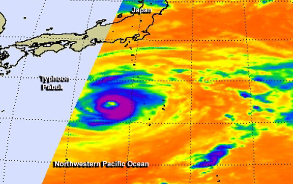
This false-colored infrared image of Typhoon Pabuk was taken from the AIRS instrument aboard NASA's Aqua satellite on September 24 at 16:05 UTC when Pabuk's eye was still visible. Image credit: NASA JPL, Ed Olsen
When NASA's Aqua satellite passed over Typhoon Pabuk on September 24 at 16:05 UTC the Atmospheric Infrared Sounder instrument viewed the storm in infrared light. The AIRS data clearly showed that Pabuk had a 30 nautical mile/34.5 mile/55.5 km wide-eye. AIRS data also showed that the eye was surrounded by powerful thunderstorms that stretched high into the troposphere and were likely generating heavy rainfall. Infrared data revealed cloud top temperatures exceeding -63F/-52C that indicates powerful storms.
The Moderate Resolution Imaging Spectroradiometer or MODIS instrument that flies aboard NASA's Terra satellite captured this image of Typhoon Pabuk on September 25 at 01:35 UTC on its approach to Japan. Image credit: NASA Goddard MODIS Rapid Response Team
On September 25 at 01:35 UTC as NASA's Terra satellite passed over Typhoon Pabuk, the Moderate Resolution Imaging Spectroradiometer or MODIS instrument captured a visible image of the storm that showed the center filled in by high clouds. The eye has also diminished in size and was 25 nautical miles/46.3 km/28.7 miles in diameter.
By 06:00 UTC on the September 25, Pabuk's maximum sustained winds were near 90 knots/166.7 km/h/103.6 mph. The typhoon was centered near 29.9 north latitude and 139.7 east longitude, about 361 nautical miles/415.4 miles/668.6 km south of Yokosuka, Japan. Pabuk was moving to the north-northeast 9 knots//16.6 km/h/10.3 mph and is forecast to bypass Japan.
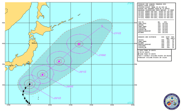
Typhoon Pabuk forecast track. Image credit: JTWC
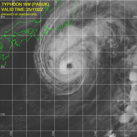
IR satellite image of Typhoon Pabuk on September 25, 2013. Image credit: JTWC
The Typhoon has been moving counter-clockwise around a large area of high pressure and is now rounding the northwestern edge of it. As a result, Pabuk is now on a north-northeasterly path that will shift to the northeast. Pabuk is expected to remain at sea in the Northwestern Pacific Ocean as it transitions to an extra-tropical storm by September 27.
I'm a dedicated researcher, journalist, and editor at The Watchers. With over 20 years of experience in the media industry, I specialize in hard science news, focusing on extreme weather, seismic and volcanic activity, space weather, and astronomy, including near-Earth objects and planetary defense strategies. You can reach me at teo /at/ watchers.news.
Commenting rules and guidelines
We value the thoughts and opinions of our readers and welcome healthy discussions on our website. In order to maintain a respectful and positive community, we ask that all commenters follow these rules.