
Strong M 5.3 earthquake off the coast of Antigua and Barbuda
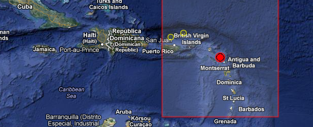
Image credit: Google 2013. Image: TerraMetrics 2013.
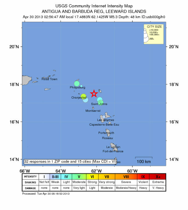
A strong earthquake registered as M 5.3 occurred off the coast of Barbuda, eastern Caribbean, on April 30, 2013 at 06:56 UTC. The epicenter was located in sea, about 50 km off the coast or 37 km (22 miles) WSW of Codrington, Barbuda, 51 km (31 miles) NW of Saint John’s, Antigua and Barbuda, 65 km (40 miles) ENE of Basseterre, Saint Kitts and Nevis, 136 km (84 miles) NNW of Sainte-Rose, Guadeloupe at coordinates 17.488°N, 62.142°W.
USGS reported depth of 48.9 km (30.4 miles) and EMSC registered M 5.4 at depth of 48 km.
| Magnitude | 5.3 |
|---|---|
| Date-Time |
|
| Location | 17.488°N, 62.142°W |
| Depth | 48.9 km (30.4 miles) |
| Region | ANTIGUA AND BARBUDA REG, LEEWARD ISLANDS |
| Distances | 37 km (22 miles) WSW of Codrington, Barbuda 51 km (31 miles) NW of Saint John’s, Antigua and Barbuda 65 km (40 miles) ENE of Basseterre, Saint Kitts and Nevis 136 km (84 miles) NNW of Sainte-Rose, Guadeloupe |
| Location Uncertainty | horizontal +/- 13.5 km (8.4 miles); depth +/- 8.2 km (5.1 miles) |
| Parameters | NST= 67, Nph= 68, Dmin=42.3 km, Rmss=0.87 sec, Gp= 86°, M-type=body wave magnitude (Mb), Version=9 |
| Source |
|
| Event ID | usb000gih0 |
 Antigua and Barbuda is a twin-island nation lying between the Caribbean Sea and the Atlantic Ocean. It consists of two major inhabited islands, Antigua and Barbuda, and a number of smaller islands. Separated by a few nautical miles, Antigua and Barbuda are in the middle of the Leeward Islands, part of the Lesser Antilles, roughly at 17 degrees north of the Equator.
Powerful M 7.5 earthquake occurred in the area in 1974.
Tectonic summary by USGS
Seismotectonics of the Caribbean Region and Vicinity
Extensive diversity and complexity of tectonic regimes characterizes the perimeter of the Caribbean plate, involving no fewer than four major plates (North America, South America, Nazca, and Cocos). Inclined zones of deep earthquakes (Wadati-Benioff zones), ocean trenches, and arcs of volcanoes clearly indicate subduction of oceanic lithosphere along the Central American and Atlantic Ocean margins of the Caribbean plate, while crustal seismicity in Guatemala, northern Venezuela, and the Cayman Ridge and Cayman Trench indicate transform fault and pull-apart basin tectonics.
Along the northern margin of the Caribbean plate, the North America plate moves westwards with respect to the Caribbean plate at a velocity of approximately 20 mm/yr. Motion is accommodated along several major transform faults that extend eastward from Isla de Roatan to Haiti, including the Swan Island Fault and the Oriente Fault. These faults represent the southern and northern boundaries of the Cayman Trench. Further east, from the Dominican Republic to the Island of Barbuda, relative motion between the North America plate and the Caribbean plate becomes increasingly complex and is partially accommodated by nearly arc-parallel subduction of the North America plate beneath the Caribbean plate. This results in the formation of the deep Puerto Rico Trench and a zone of intermediate focus earthquakes (70-300 km depth) within the subducted slab. Although the Puerto Rico subduction zone is thought to be capable of generating a megathrust earthquake, there have been no such events in the past century. The last probable interplate (thrust fault) event here occurred on May 2, 1787 and was widely felt throughout the island with documented destruction across the entire northern coast, including Arecibo and San Juan. Since 1900, the two largest earthquakes to occur in this region were the August 4, 1946 M8.0 Samana earthquake in northeastern Hispaniola and the July 29, 1943 M7.6 Mona Passage earthquake, both of which were shallow thrust fault earthquakes. A significant portion of the motion between the North America plate and the Caribbean plate in this region is accommodated by a series of left-lateral strike-slip faults that bisect the island of Hispaniola, notably the Septentrional Fault in the north and the Enriquillo-Plantain Garden Fault in the south. Activity adjacent to the Enriquillo-Plantain Garden Fault system is best documented by the devastating January 12, 2010 M7.0 Haiti strike-slip earthquake, its associated aftershocks and a comparable earthquake in 1770. Read the rest of tectonic summary here.
Commenting rules and guidelines
We value the thoughts and opinions of our readers and welcome healthy discussions on our website. In order to maintain a respectful and positive community, we ask that all commenters follow these rules.