
Deadly earthquake and flash floods hit northern Afghanistan
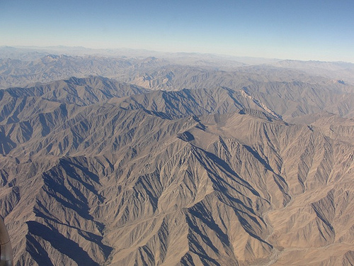
Image credit: Hindu Kush range by Michal Hvorecky
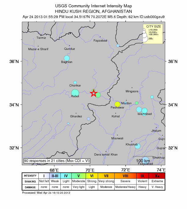
A deadly earthquake magnitude 5.6 (USGS) struck Hindu Kush, northeastern Afghanistan, on April 24, 2013 at 09:25 UTC (13:55 local time). Epicenter was located in Nangarhar province, 11 km (6 miles) S of Mehtar Lam, Afghanistan and 25 km (15 miles) NW of Jalalabad, Afghanistan, at coordinates 34.517°N, 70.207°E. USGS measured depth at 62.1 km.
Pakistan Meteorological Department is reporting M 6.2 at depth of 72 km.
GDACS reported that this earthquake can have a medium humanitarian impact based on the magnitude and the affected population and their vulnerability. There are 7 830 000 people living within 100 km.
Hundreds of homes collapsed across Kunar and Nangarhar. By unofficial numbers there were 25 people killed and 120 are reportedly injured (20:30 UTC). It is past midnight in Afghanistan now (UTC +4:30h), and many people are still believed to be under the rubble. New reports should come about in the morning.
Additionally, flash floods were reported in northern Afghanistan, Balkh province, earlier today, as well as landslides. On Tuesday, April 23rd, heavy rains sent deluges down hillsides of villages in the remote districts of Kishindih, Sholgara and Nahri Shai. National Disaster Management Authority said that steady rain across most of Afghanistan today would have weakened the mud-brick dwellings many Afghans live in (NST). AP photo here.
At least 15 people were killed in flash floods, official reports said today. In its preliminary report, the U.N. said flooding also closed major roads in Balkh.
The map of Afghanistan provinces is here.
| Magnitude | 5.6 |
|---|---|
| Date-Time |
|
| Location | 34.517°N, 70.207°E |
| Depth | 62.1 km (38.6 miles) |
| Region | HINDU KUSH REGION, AFGHANISTAN |
| Distances | 11 km (6 miles) S of Mehtar Lam, Afghanistan 25 km (15 miles) NW of Jalalabad, Afghanistan 66 km (41 miles) NW of Markaz-e Woluswali-ye Achin, Afghanistan 69 km (42 miles) NE of Hukumati Azrow, Afghanistan |
| Location Uncertainty | horizontal +/- 10.1 km (6.3 miles); depth +/- 6.1 km (3.8 miles) |
| Parameters | NST=267, Nph=405, Dmin=106.9 km, Rmss=0.77 sec, Gp= 22°, M-type=body wave magnitude (Mb), Version=D |
| Source |
|
| Event ID | usb000geu9 |
Regional seismicity
Earthquakes in Hindu Kush and broader region are common and occur as a result of the collision of the India and Eurasia continental plates. Indian subcontinent is moving northward at a rate of about 40 mm/yr (1.6 inches/yr) and colliding with the Eurasian continent. Underthrusting of India beneath Eurasia generates numerous earthquakes and consequently makes this area one of the most seismically hazardous regions on Earth. This collision is causing uplift that produces the highest mountain peaks in the world including the Himalayan, the Karakoram, the Pamir and the Hindu Kush ranges.
The worst earthquake to hit Afghanistan in recent years occurred on May 30, 1998. A 6.9 magnitude earthquake struck Takhar and Badakhshan provinces. Between 4,000 and 4,500 people died.
As a result of this same tectonic collisions on October 8, 2005, a magnitude 7.6 earthquake and a series of aftershocks struck Kashmir near the city of Muzaffarabad, Pakistan. It left nearly 75,000 people dead, injured more than 100,000 people, and destroyed 3 million homes. That earthquake actually split the Earth’s surface in an event geologists call a surface rupture. This surface rupture extended for 75 kilometers (47 miles). Robert Yeats, a geologist at Oregon State University, concluded after traveling to Pakistan that in the known historic and recent records, not one of the earthquakes in the Himalaya has ever produced a surface rupture, not in Nepal, or India, or anywhere. This rupture was the first one (EO). In some areas, the earthquake shifted the ground more than 5 meters (16 feet).
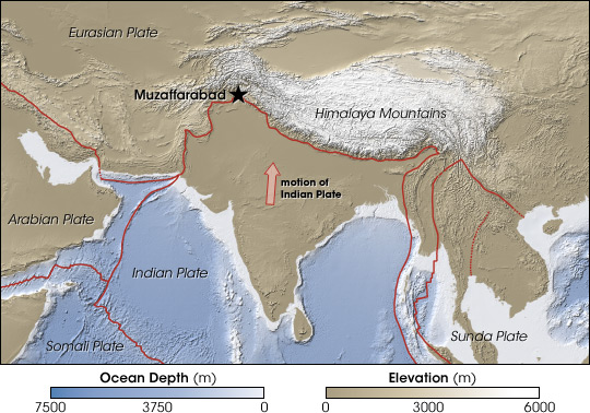
Muzaffarabad sits at the boundary between the slowly colliding Indian and Eurasian tectonic plates, both composed of thick continental crust. The pressure of the collision isn’t released gradually, but suddenly, when rocks that can no longer bear the stress crack. These forces make Kashmir one of the most earthquake-prone regions on Earth. (NASA map by Robert Simmon, from CleanTOPO2 data.)
Tectonic summary by USGS
Seismotectonics of the Himalaya and Vicinity
… The India-Eurasia plate boundary is a diffuse boundary, which in the region near the north of India, lies within the limits of the Indus-Tsangpo (also called the Yarlung-Zangbo) Suture to the north and the Main Frontal Thrust to the south. The Indus-Tsangpo Suture Zone is located roughly 200 km north of the Himalaya Front and is defined by an exposed ophiolite chain along its southern margin. The narrow (<200km) Himalaya Front includes numerous east-west trending, parallel structures. This region has the highest rates of seismicity and largest earthquakes in the Himalaya region, caused mainly by movement on thrust faults. Examples of significant earthquakes, in this densely populated region, caused by reverse slip movement include the 1934 M8.1 Bihar, the 1905 M7.5 Kangra and the 2005 M7.6 Kashmir earthquakes. The latter two resulted in the highest death tolls for Himalaya earthquakes seen to date, together killing over 100,000 people and leaving millions homeless. The largest instrumentally recorded Himalaya earthquake occurred on 15th August 1950 in Assam, eastern India. This M8.6 right-lateral, strike-slip, earthquake was widely felt over a broad area of central Asia, causing extensive damage to villages in the epicentral region.
The Tibetan Plateau is situated north of the Himalaya, stretching approximately 1000km north-south and 2500km east-west, and is geologically and tectonically complex with several sutures which are hundreds of kilometer-long and generally trend east-west. The Tibetan Plateau is cut by a number of large (>1000km) east-west trending, left-lateral, strike-slip faults, including the long Kunlun, Haiyuan, and the Altyn Tagh. Right-lateral, strike-slip faults (comparable in size to the left-lateral faults), in this region include the Karakorum, Red River, and Sagaing. Secondary north-south trending normal faults also cut the Tibetan Plateau. Thrust faults are found towards the north and south of the Tibetan Plateau. Collectively, these faults accommodate crustal shortening associated with the ongoing collision of the India and Eurasia plates, with thrust faults accommodating north south compression, and normal and strike-slip accommodating east-west extension. Read the rest of tectonic summary here.
I'm a dedicated researcher, journalist, and editor at The Watchers. With over 20 years of experience in the media industry, I specialize in hard science news, focusing on extreme weather, seismic and volcanic activity, space weather, and astronomy, including near-Earth objects and planetary defense strategies. You can reach me at teo /at/ watchers.news.
Commenting rules and guidelines
We value the thoughts and opinions of our readers and welcome healthy discussions on our website. In order to maintain a respectful and positive community, we ask that all commenters follow these rules.