
First sightings of how a Coronal Mass Ejection (CME) forms
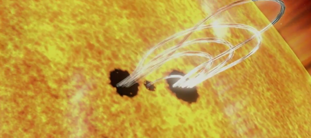
Image credit: TW
On July 18, 2012, a fairly small explosion of light burst off the lower right limb of the sun. Such flares often come with an associated eruption of solar material, known as a coronal mass ejection or CME – but this one did not.
Something interesting did happen, however. Magnetic field lines in this area of the sun’s atmosphere, the corona, began to twist and kink, generating the hottest solar material — a charged gas called plasma — to trace out the newly-formed slinky shape. The plasma glowed brightly in extreme ultraviolet images from the Atmospheric Imaging Assembly (AIA) aboard NASA’s Solar Dynamics Observatory (SDO) and scientists were able to watch for the first time the very formation of something they had long theorized was at the heart of many eruptive events on the sun: a flux rope.
Eight hours later, on July 19, the same region flared again. This time the flux rope’s connection to the sun was severed, and the magnetic fields escaped into space, dragging billions of tons of solar material along for the ride – a classic CME.

Such flux ropes have been seen in images of CMEs as they fly away from the sun, but it’s never been known – indeed, has been strongly debated – whether the flux rope formed before or in conjunction with a CME’s launch. This case shows a clear-cut example of the flux rope forming ahead of time.
Credit: NASA SDO / NASA Goddard Space Flight Center

Teo Blašković founded The Watchers in 2011 and edited it until 2026, covering seismic and volcanic activity, extreme weather, space weather and near-Earth objects. Articles on this page are his archive.
Earlier reporting
Nothing on Watchers was published in the last 24 hours. These are older articles.
- On October 22, 2017, a single flash of lightning stretched 515 miles from eastern Texas to near Kansas City, a distance that takes eight hours to drive, and nobody realized how far it had gone until scientists went back through the satellite data years later Epicenter
- CPC posts a slight risk of heavy rain from the Gulf Coast to the Northeast urban corridor November 25-29, and a moderate risk of West Coast wind and Sierra snow on November 25
- Florida's east coast faces a moderate flash flood risk Wednesday through Friday, with 4 to 8 inches of rain forecast and the St. Johns River near Cocoa already in major flood at 17.13 feet
- Cyclone Akvan to make landfall between Nellore and Visakhapatnam around noon on November 20, IMD forecasts 120-130 km/h winds gusting to 145
