
Super Typhoon Champi becomes the strongest tropical cyclone of 2026, Signal No. 2 remains over Batanes, Philippines
Super Typhoon Champi, locally named Rosal, became the strongest tropical cyclone of 2026 by maximum sustained wind speed when it reached 296 km/h (185 mph) on October 20, according to NASA’s MODIS program. The cyclone weakened on October 21 while moving toward waters east of the northern Philippines, where PAGASA maintained Tropical Cyclone Wind Signal No. 2 over Batanes and warned of heavy rain and waves reaching 10 m (33 feet).
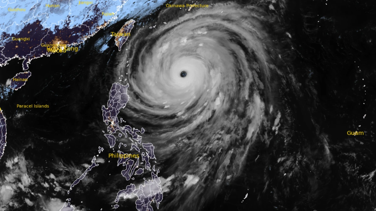
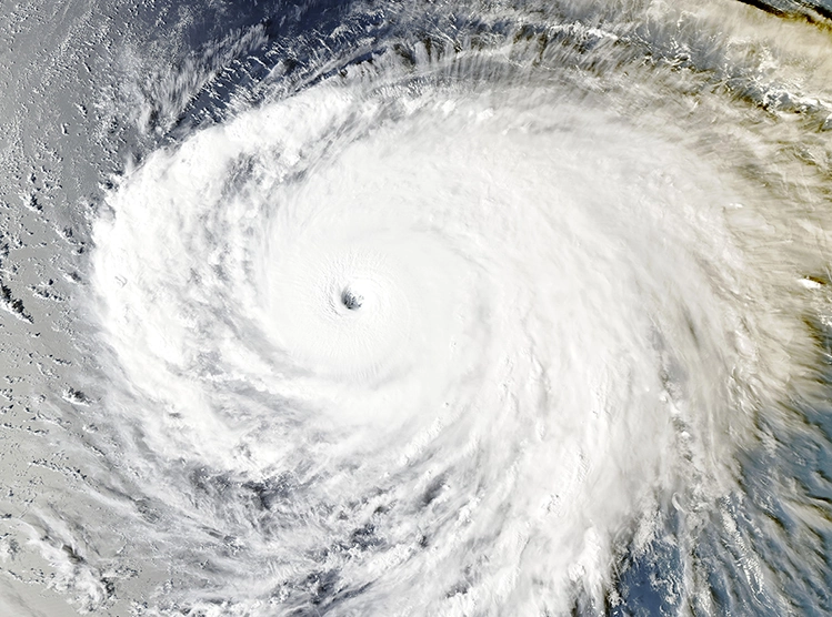
Satellite image of Super Typhoon Champi at 12:10 UTC on October 21, 2026. Credit: JMA/Himawari-9, RAMMB/CIRA, The Watchers
The Philippine Atmospheric, Geophysical and Astronomical Services Administration (PAGASA) located Rosal about 725 km (450 miles) east of Aparri, Cagayan, at 17:00 PHT (09:00 UTC) on October 21.
PAGASA estimated maximum sustained winds of 205 km/h (127 mph), with gusts reaching 250 km/h (155 mph). The cyclone was moving west-northwest at 25 km/h (16 mph).
Tropical Cyclone Wind Signal No. 2 remained in effect over Batanes. PAGASA said winds greater than 62 km/h and up to 88 km/h (39–55 mph) could produce minor to moderate impacts in exposed communities.
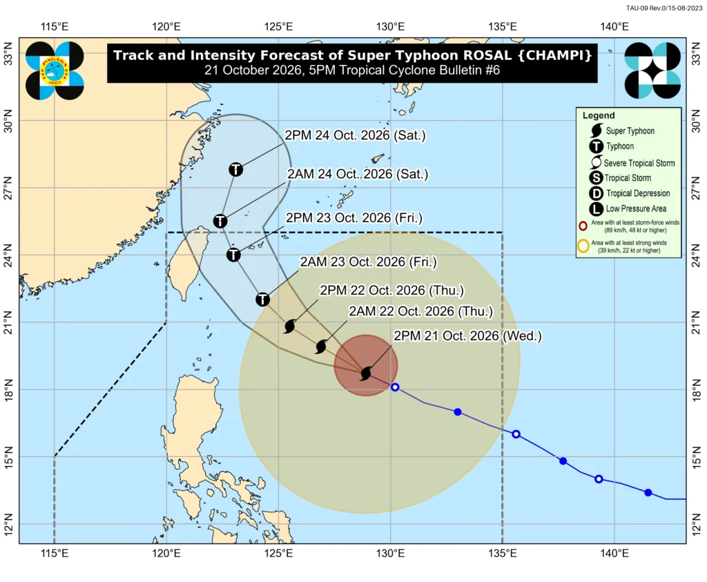
Signal No. 1 covered Cagayan, including the Babuyan Islands, eastern portions of Isabela, Ilocos Norte, Apayao and northeastern Catanduanes. PAGASA said Signal No. 3 remained the highest signal that could be raised during Rosal’s passage.
PAGASA forecast more than 200 mm (8 inches) of rain over Batanes from the evening of October 21 through the afternoon of October 22. Totals of 100–200 mm (4–8 inches) were forecast over the Babuyan Islands, with 50–100 mm (2–4 inches) over northern and eastern Cagayan.
Another period exceeding 200 mm (8 inches) was forecast over Batanes from the afternoon of October 22 through October 23. PAGASA warned that rainfall could be higher over elevated terrain and that flooding and landslides were possible in susceptible areas.
Marine conditions were forecast to deteriorate sharply. PAGASA forecast waves reaching 10 m (33 feet) along the northern and eastern coasts of Batanes, 9 m (30 feet) around the remaining Batanes coast and eastern Babuyan Islands, and 8 m (26 feet) along northern Babuyan Islands and northeastern mainland Cagayan.
A Gale Warning covered the northern and eastern seaboards of Luzon and the eastern seaboard of the Visayas. PAGASA advised vessels in the most severely affected waters to remain in port or seek safe harbor.
Rosal is forecast to move west-northwest through October 21, northwest on October 22, and north-northwest on October 23. PAGASA expects the center to pass closest to Extreme Northern Luzon between the afternoon of October 22 and the morning of October 23, while remaining offshore under the current forecast.
The center is forecast to pass about 370 km (230 miles) east of Basco, Batanes, at 14:00 PHT on October 22 and 290 km (180 miles) east-northeast of Itbayat at 02:00 PHT on October 23. Rosal is expected to leave the Philippine Area of Responsibility Friday evening or early October 24.
PAGASA forecasts Rosal to weaken into a typhoon by October 23 and continue weakening near Taiwan. The agency cautioned that heavy rain and severe winds can occur outside the forecast cone and that the track remains subject to change.
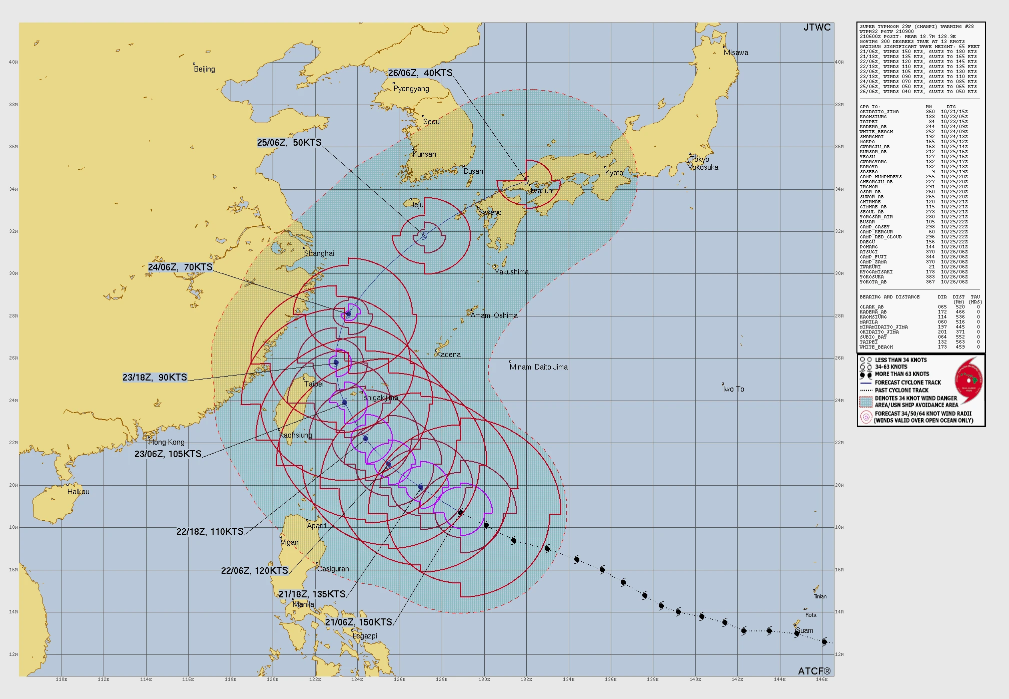
The Joint Typhoon Warning Center (JTWC) analyzed Champi near 18.7°N, 128.9°E at 09:00 UTC on October 21, with maximum one-minute sustained winds of 278 km/h (173 mph). It was moving west-northwest at about 24 km/h (15 mph).
Satellite imagery showed a well-defined eye approximately 56 km (35 miles) across within a symmetrical central dense overcast. JTWC estimated significant wave heights near the cyclone at 19.8 m (65 feet).
PAGASA and JTWC use different wind-averaging periods and analysis methods. Their respective wind estimates of 205 km/h (127 mph) and 278 km/h (173 mph) therefore should not be interpreted as directly comparable measurements.
JTWC said cooler sea-surface temperatures of 27–28°C (81–82°F) and lower ocean heat content were expected to support steady to rapid weakening despite low vertical wind shear and strong outflow.
Track guidance agreed through approximately 24 hours but divided substantially afterward. Physics-based models showed a possible landfall over central or northern Taiwan, while artificial-intelligence models recurved Champi toward or just north of Kyushu, Japan.
JTWC rated both track and intensity confidence as low throughout the five-day forecast. It said the timing and location of Champi’s eventual approach toward Taiwan or Japan could change significantly as guidance converges.
Taiwan’s Central Weather Administration (CWA) placed Champi near 18.7°N, 128.9°E at 14:00 local time on October 21. It estimated a central pressure of 900 hPa and maximum sustained winds of 209 km/h (130 mph), with northwestward motion at 19 km/h (12 mph).
CWA said a sea warning could be issued late October 21 or early October 22 as the projected track shifted westward. The agency said Champi’s wind field could expand while approaching waters east of Taiwan.
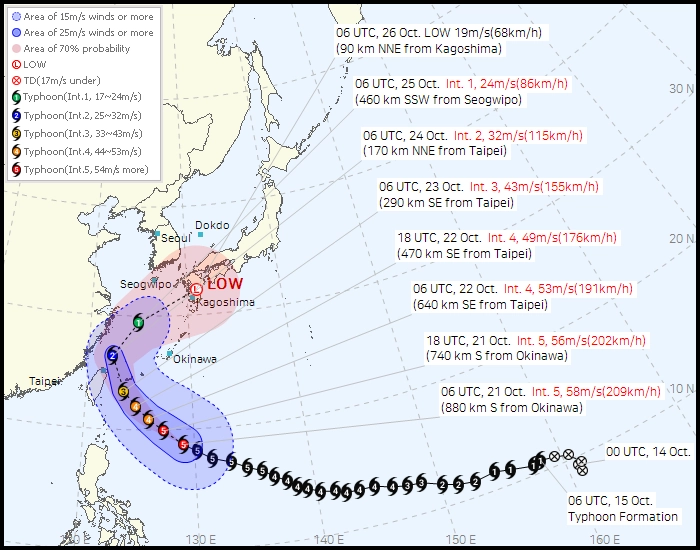
The Korea Meteorological Administration (KMA) analyzed Champi at 905 hPa with maximum sustained winds of 209 km/h (130 mph) at 06:00 UTC on October 21. Its forecast placed the cyclone near 29.4°N, 124.9°E on October 25 with winds of approximately 86 km/h (53 mph), followed by a transition into a low-pressure system near 32.3°N, 131.0°E on October 26.
KMA forecast rain across Chungcheong, southern South Korea and Jeju from October 25 into the morning of October 26. The agency said the affected areas and timing could change depending on Champi’s track, intensity and the surrounding pressure pattern.
Philippine authorities began preparing ahead of the cyclone. The Department of Social Welfare and Development said food and other relief supplies had been positioned in Batanes and other communities that could become isolated by severe weather.
In Catanduanes, where five municipalities were under Signal No. 1, the Philippine Coast Guard suspended affected sea voyages. Provincial authorities placed rescue teams and supplies on standby and directed local councils to prepare for possible evacuations from disaster-prone areas.
Champi previously passed about 16 km (10 miles) south of Guam’s southern tip at approximately 04:26 ChST on October 18. Guam International Airport recorded occasional typhoon-force gusts near 129 km/h (80 mph), while the island’s weather radar temporarily went offline before returning to service at 07:14 ChST.
Widespread power outages occurred, particularly across southern Guam, but the Guam Power Authority said the island did not experience a system-wide blackout. At 09:00 ChST on October 18, approximately 51% of distribution feeders and circuits remained online.
Following the Guam passage, Champi intensified further over the Philippine Sea. NASA’s MODIS program said maximum sustained winds reached 296 km/h (185 mph) on October 20, making Champi the strongest tropical cyclone of 2026 so far by wind speed.
References:
1 Prognostic Reasoning for Super Typhoon 29W, Warning Number 28 – JTWC – October 21, 2026
2 Typhoon Information: Champi – KMA – October 21, 2026
3 Tropical Cyclone Bulletin #6 — Super Typhoon Rosal – PAGASA – October 21, 2026

Rishav Kothari is Editor-in-Chief of The Watchers, where he runs the newsroom and covers earthquakes, volcanoes, severe weather and space weather.
Published in the last 24 hours
- In 2017, El Niño rains turned part of Peru's Sechura Desert into a lake more than four times the size of Lake Tahoe, and families went out on wooden rafts to fish it Epicenter
- A rose-colored rock found in the Sahara in 2022 turned out to be a piece of Mars more than 4.1 billion years old Epicenter
- Northern lights are possible at high latitudes on November 17 and 18 as NOAA forecasts minor (G1) geomagnetic storms from coronal hole wind
- In February 2022, SpaceX launched 49 Starlink satellites into a solar storm so mild that forecasters rated it minor, and within days 38 of them had fallen back and burned up, because the storm had swollen the thin air they were flying through Epicenter
