
Active volcanoes in the world: June 27 – July 3, 2012
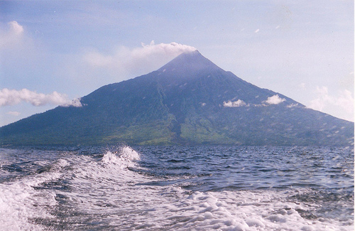
Image credit: flickrhivemind.net/Tags/manam/Interesting
New unrest has been noticed around 5 volcanoes, ongoing activity was reported for 10 volcanoes. This report covers active volcanoes in the world recorded from June 27 – July 3, 2012 based on Smithsonian/USGS criteria.
FUEGO, Guatemala
14.473°N, 90.880°W; summit elev. 3763 m
INSIVUMEH reported that during 28-29 June activity at Fuego increased; explosions produced ash plumes that rose 500-600 m above the crater and drifted SW. Pulses of incandescence rose 200 m and tephra avalanches descended the Ceniza drainage (SSW). According to Coordinadora Nacional para la Reducción de Desastres (CONRED) on 1 July, seismicity increased and rumbling sounds were audible in areas up to 10 km away. A lava flow 700 m long was active in the Taniluya drainage on the SW flank. In a 2 July report, INSIVUMEH noted that the lava flow on the SW flank was 1,700 m long. Ash plumes rose 500 m above the crater and drifted 10 km W. The seismic network recorded continuous tremor. During 2-3 July explosions produced ash plumes that rose 400 m above the crater and drifted W. A lava flow traveled 400 m down the Taniluya drainage, and blocks from the flows reached vegetated areas.
Geologic summary: Volcán Fuego, one of Central America’s most active volcanoes, is one of three large stratovolcanoes overlooking Guatemala’s former capital, Antigua. The scarp of an older edifice, Meseta, lies between 3,763-m-high Fuego and its twin volcano to the N, Acatenango. Construction of Meseta volcano continued until the late Pleistocene or early Holocene, after which growth of the modern Fuego volcano continued the southward migration of volcanism that began at Acatenango. Frequent vigorous historical eruptions have been recorded at Fuego since the onset of the Spanish era in 1524, and have produced major ashfalls, along with occasional pyroclastic flows and lava flows. The last major explosive eruption from Fuego took place in 1974, producing spectacular pyroclastic flows visible from Antigua.
HIERRO, Canary Islands (Spain)
27.73°N, 18.03°W; summit elev. 1500 m
On the night of 24 June, a M 3.1 earthquake occurred offshore N of El Hierro island at a depth of 20 km. After that event, both the seismic activity and the deformation greatly increased. The seismicity, initially located N of the island in the El Golfo area, migrated S, then later to the W, along the E-W rift zone. On 27 June, the Plan de Protección Civil por Riesgo Volcánico (PEVOLCA) raised the Alert Level to Yellow (on a three-color, traffic-light scale) for areas near El Julan (along the SW coast) and La Dehesa; The Alert Level remained at Green for the rest of the island.
On 28 June, seismicity migrated to the SW in Las Calmas Sea and remained SW of the island, mainly offshore, until 3 July. The depth of the events was concentrated around 20 km. Since 24 June, more than 1,500 events have been located, and more than 250 of those events were M 2.7 and higher and often felt by residents. The biggest event was a M 4.4 that occurred on 2 July at 2242, located offshore SW the island, at 19 km depth. High deformation rates were measured by every GPS station on the island, reaching 8 cm in the horizontal component and about 10 cm of vertical displacement.
Geologic summary: The triangular island of Hierro is the SW-most and least studied of the Canary Islands. The massive Hierro shield volcano is truncated by a large NW-facing escarpment formed as a result of gravitational collapse of El Golfo volcano about 130,000 years ago. The steep-sided 1500-m-high scarp towers above a low lavaplatform bordering 12-km-wide El Golfo Bay, and three other large submarine landslide deposits occur to the SW and SE. Three prominent rifts oriented NW, NE, and south at 120 degree angles form prominent topographic ridges. The subaerial portion of the volcano consists of flat-lying Quaternary basaltic and trachybasaltic lava flows and tuffs capped by numerous young cinder cones and lava flows. Holocene cones and flows are found both on the outer flanks and in the El Golfo depression. Hierro contains the greatest concentration of young vents in the Canary Islands. Uncertainty surrounds the report of an historical eruption in 1793.
MANAM, Northeast of New Guinea (SW Pacific)
4.080°S, 145.037°E; summit elev. 1807 m
RVO reported that four pyroclastic flows traveled down Manam’s SE flank on 16 June. The following day activity was low; emissions were mostly steam with occasional ash. During 18-30 June gray ash clouds, that were sometimes black, rose 100-150 m above the crater and drifted mainly NW. Roaring and rumbling noises were sometimes reported. Incandescent tephra was ejected from the crater on most nights; activity during 28-29 June was almost Subplinian. Emissions from Main Crater were milder and mostly characterized by white and bluish plumes. Gray ash plumes were emitted during 18, 23, 26-27, and 29 June. Incandescence from the crater was visible during 18, 20-22, and 24 June. Ash fell in the NW part of the island.
Geologic summary: The 10-km-wide island of Manam, lying 13 km off the northern coast of mainland Papua New Guinea, is one of the country’s most active volcanoes. Four large radial valleys extend from the unvegetated summit of the conical 1807-m-high basaltic-andesitic stratovolcano to its lower flanks. These “avalanche valleys,” regularly spaced 90 degrees apart, channel lava flows and pyroclastic avalanches that have sometimes reached the coast. Two summit craters are present; both are active, although most historical eruptions have originated from the southern crater, concentrating eruptive products during much of the past century into the SE avalanche valley. Frequent historical eruptions, typically of mild-to-moderate scale, have been recorded at Manam since 1616. Occasional larger eruptions have produced pyroclastic flows and lava flows that reached flat-lying coastal areas and entered the sea, sometimes impacting populated areas.
NEVADO DEL RUIZ, Colombia
4.895°N, 75.322°W; summit elev. 5321 m
According to INGEOMINAS, the Observatorio Vulcanológico and Sismológico de Manizales reported that a significant concentration of sulfur dioxide was detected rising from Nevado del Ruiz during 28-29 June. Seismic signals indicated continuing gas and ash emissions.
On 30 June an eruption produced an ash plume that rose 8 km above the crater and drifted SW. The Alert Level was raised to I (Red; “imminent eruption or in progress”). Ashfall was reported in areas near the volcano including Manizales (30 km NW) and Villamaría (28 km NW). According to news reports, communities around the volcano evacuated, and airports in Manizales, Pereira, and Armenia closed. By 2 July seismicity had decreased to low levels; the Alert Level was lowered to II (Orange; “eruption likely within days or weeks”). The Washington VAAC reported that a 7.5-km-wide ash plume was detected in satellite imagery drifting 75 km W. INGEOMINAS noted that seismic signals indicated continuing gas and ash emissions on 3 July.
Geologic summary: Nevado del Ruiz is a broad, glacier-covered volcano in central Colombia that covers >200 sq km. Three major edifices, composed of andesitic and dacitic lavas and andesitic pyroclastics, have been constructed since the beginning of the Pleistocene. The modern cone consists of a broad cluster of lava domes built within the summit caldera of an older Ruiz volcano. The 1-km-wide, 240-m-deep Arenas crater occupies the summit. Steep headwalls of massive landslides cut the flanks of Nevado del Ruiz. Melting of its summit icecap during historical eruptions, which date back to the 16th century, has resulted in devastating lahars, including one in 1985 that was South America’s deadliest eruption.
SPURR, Southwestern Alaska
61.299°N, 152.251°W; summit elev. 3374 m
AVO reported that a minor increase in seismicity at Spurr was detected at about 0500 on 25 June, lasted about 45 minutes, and was characterized by several discrete M1earthquakes. The signals recorded were consistent with seismic energy generated by an energetic flow of water, possibly indicating a glacial outburst flood on the lower S flank. The next day seismic levels had declined to near background and no additional flowage signals were observed.
Geologic summary: The 3,374-m-high summit of Mount Spurr, the highest volcano of the Aleutain arc, is a large lava dome constructed at the center of a roughly 5-km-wide horseshoe-shaped caldera that is open to the S. The volcano lies 130 km W of Anchorage, NE of Chakachamna Lake. The caldera was formed by a late-Pleistocene or early Holocene debris avalanche and associated pyroclastic flows that destroyed an ancestral Spurr volcano. The debris avalanche traveled more than 25 km to the SE, and the resulting deposit contains blocks as large as 100 m in diameter. Several ice-carved post-caldera cones or lava domes lie in the center of the caldera. The youngest vent, 2,309-m-high Crater Peak, formed at the southern breached end of the caldera and has been the source of about 40 identified Holocene tephra layers. Spurr’s two historical eruptions, from Crater Peak in 1953 and 1992, deposited ash on the city of Anchorage.
Ongoing activity
BATU TARA, Komba Island (Indonesia)
7.792°S, 123.579°E; summit elev. 748 m
Based on analyses of satellite imagery, the Darwin VAAC reported that on 27 June ash plumes from Batu Tara rose to an altitude of 1.8 km (6,000 ft) a.s.l. and drifted almost 30 km NW.
Geologic summary: The small isolated island of Batu Tara in the Flores Sea about 50 km north of Lembata (formerly Lomblen) Island contains a scarp on the eastern side similar to the Sciara del Fuoco of Italy’s Stromboli volcano. Vegetation covers the flanks of Batu Tara to within 50 m of the 748-m-high summit. Batu Tara lies north of the main volcanic arc and is noted for its potassic leucite-bearing basanitic and tephritic rocks. The first historical eruption from Batu Tara, during 1847-52, produced explosions and a lava flow.
CLEVELAND, Chuginadak Island
52.825°N, 169.944°W; summit elev. 1730 m
AVO reported that cloudy conditions at Cleveland mostly prevented observations during 26-28 June. An area of possibly elevated surface temperatures was observed in images during 27-28 June. Cloud cover prevented observations during 29 June-3 July. The Volcano Alert Level remained at Watch and the Aviation Color Coderemained at Orange.
Geologic summary: Symmetrical Mount Cleveland stratovolcano is situated at the western end of the uninhabited dumbbell-shaped Chuginadak Island in the east-central Aleutians. The 1,730-m-high stratovolcano is the highest of the Islands of Four Mountains group and is one of the most active in the Aleutians. Numerous large lava flows descend its flanks. It is possible that some 18th to 19th century eruptions attributed to Carlisle (a volcano located across the Carlisle Pass Strait to the NW) should be ascribed to Cleveland. In 1944 Cleveland produced the only known fatality from an Aleutian eruption. Recent eruptions from Mt. Cleveland have been characterized by short-lived explosive ash emissions, at times accompanied by lava fountaining and lava flows down the flanks.
DUKONO, Halmahera
1.68°N, 127.88°E; summit elev. 1335 m
Based on analyses of satellite imagery, the Darwin VAAC reported that during 28-29 June ash plumes from Dukono rose to an altitude of 3 km (10,000 ft) a.s.l. and drifted 75 km NE and E.
Geologic summary: Reports from this remote volcano in northernmost Halmahera are rare, but Dukono has been one of Indonesia’s most active volcanoes. More-or-less continuous explosive eruptions, sometimes accompanied by lava flows, occurred from 1933 until at least the mid-1990s, when routine observations were curtailed. During a major eruption in 1550, a lava flow filled in the strait between Halmahera and the N-flank cone of Gunung Mamuya. Dukono is a complex volcano presenting a broad, low profile with multiple summit peaks and overlapping craters. Malupang Wariang, 1 km SW of Dukono’s summit crater complex, contains a 700 x 570 m crater that has also been active during historical time.
KARYMSKY, Eastern Kamchatka (Russia)
54.05°N, 159.45°E; summit elev. 1536 m
KVERT reported that moderate seismic activity from Karymsky continued to be detected during 22-29 June, and indicated that possible ash plumes rose to an altitude of 3.6 km (11,800 ft) a.s.l. Satellite imagery showed a weak thermal anomaly on the volcano on 22 June. The Aviation Color Code remained at Orange.
Geologic summary: Karymsky, the most active volcano of Kamchatka’s eastern volcanic zone, is a symmetrical stratovolcano constructed within a 5-km-wide caldera that formed about 7,600-7,700 radiocarbon years ago. Construction of the Karymsky stratovolcano began about 2,000 years later. The latest eruptive period began about 500 years ago, following a 2,300-year quiescence. Much of the cone is mantled by lava flows less than 200 years old. Historical eruptions have been Vulcanian or Vulcanian-Strombolian with moderate explosive activity and occasional lava flows from the summit crater. Most seismicity preceding Karymsky eruptions has originated beneath Akademia Nauk caldera, which is located immediately S of Karymsky volcano and erupted simultaneously with Karymsky in 1996.
KILAUEA, Hawaii (USA)
19.421°N, 155.287°W; summit elev. 1222 m
During 27 June-3 July HVO reported that the lava lake periodically rose and fell in the deep pit within Kilauea’s Halema’uma’u Crater. Occasional measurements indicated that the gas plume from the vent continued to deposit variable amounts of ash and Pele’s hair onto nearby areas. The lava pond in a small pit on the E edge of Pu’u ‘O’o crater floor and two vents along the S edge of the floor were visible with the web cameras. Lava flows were active on the pali and coastal plain.
Geologic summary: Kilauea, one of five coalescing volcanoes that comprise the island of Hawaii, is one of the world’s most active volcanoes. Eruptions at Kilauea originate primarily from the summit caldera or along one of the lengthy E and SW rift zones that extend from the caldera to the sea. About 90% of the surface of Kilauea is formed of lava flows less than about 1,100 years old; 70% of the volcano’s surface is younger than 600 years. A long-term eruption from the East rift zone that began in 1983 has produced lava flows covering more than 100 sq km, destroying nearly 200 houses and adding new coastline to the island.
POPOCATEPETL, México
19.023°N, 98.622°W; summit elev. 5426 m
CENAPRED reported that during 27 June-3 July meteorological weather conditions often prevented observations of Popocatépetl. Gas-and-steam emissions were detected by the seismic network probably occasionally contained ash. Incandescence from the crater was intermittently observed at night and accompanied emissions during June 30-1 July. Gas-and-steam plumes rose 0.5-2 km above the crater on 27 and 29 June. Gas-and-ash plumes rose 1-2.5 km above the crater during June 30-1 July. The Alert Level remained at Yellow Phase Three.
Geologic summary: Popocatépetl, whose name is the Aztec word for smoking mountain, towers to 5,426 m 70 km SE of Mexico City and is North America’s second-highest volcano. Frequent historical eruptions have been recorded since the beginning of the Spanish colonial era. A small eruption on 21 December 1994 ended five decades of quiescence. Since 1996 small lava domes have incrementally been constructed within the summit crater and destroyed by explosive eruptions. Intermittent small-to-moderate gas-and-ash eruptions have continued, occasionally producing ashfall in neighboring towns and villages.
SAKURA-JIMA, Kyushu
31.585°N, 130.657°E; summit elev. 1117 m
JMA reported that during 25-29 June large explosive eruptions from Sakura-jima’s Showa Crater occurred ten times and ejected tephra as far as 1,300 m from the crater.
Based on information from JMA, the Tokyo VAAC reported multiple explosions during 27 June-1 July. The explosions sometimes produced plumes that rose to altitudes of 1.5-2.1 km (5,000-7,000 ft) a.s.l. and drifted E, NE, and NW. A pilot observed an ash plume on 28 June that rose to an altitude of 1.8 (6,000 ft) a.s.l.
Geologic summary: Sakura-jima, one of Japan’s most active volcanoes, is a post-caldera cone of the Aira calderaat the northern half of Kagoshima Bay. Eruption of the voluminous Ito pyroclastic flow was associated with the formation of the 17 x 23-km-wide Aira caldera about 22,000 years ago. The construction of Sakura-jima began about 13,000 years ago and built an island that was finally joined to the Osumi Peninsula during the major explosive and effusive eruption of 1914. Activity at the Kita-dake summit cone ended about 4,850 years ago, after which eruptions took place at Minami-dake. Frequent historical eruptions, recorded since the 8th century, have depositedash on Kagoshima, one of Kyushu’s largest cities, located across Kagoshima Bay only 8 km from the summit. The largest historical eruption took place during 1471-76.
SANTA MARIA, Guatemala
14.756°N, 91.552°W; summit elev. 3772 m
Based on seismic data and visual observations, INSIVUMEH reported that on 27 June a 16-m-wide, 90-cm-deeplahar traveled down Santa María’s Rio Nima I drainage, carrying rocks up to 80 cm in diameter. During 28-29 June block avalanches again traveled down the SE flank and fumarolic plumes drifted SW. During 1-3 July explosions produced ash plumes that rose 700 m above the crater and drifted SW. Ashfall was reported in La Florida (5 km S) and Monte Claro (S). Avalanches from lava flow fronts descended the SW flank.
Geologic summary: Symmetrical, forest-covered Santa María volcano is one of a chain of large stratovolcanoes that rises dramatically above the Pacific coastal plain of Guatemala. The stratovolcano has a sharp-topped, conical profile that is cut on the SW flank by a large, 1-km-wide crater, which formed during a catastrophic eruption in 1902 and extends from just below the summit to the lower flank. The renowned Plinian eruption of 1902 followed a long repose period and devastated much of SW Guatemala. The large dacitic Santiaguito lava-dome complex has been growing at the base of the 1902 crater since 1922. Compound dome growth at Santiaguito has occurred episodically from four westward-younging vents, accompanied by almost continuous minor explosions and periodic lava extrusion, larger explosions, pyroclastic flows, and lahars.
SHIVELUCH, Central Kamchatka (Russia)
56.653°N, 161.360°E; summit elev. 3283 m
KVERT reported that during 22-29 June explosive activity at Shiveluch continued and seismic data indicated that possible ash plumes rose to an altitude of 9.5 km (31,100 ft) a.s.l. Observers indicated strong gas-and-steam activity on 22 June and noted ash plumes rising to an altitude of 5.3 km (17,400 ft) a.s.l. during 24-26 June. Weather conditions prevented observations of the volcano on the other days. Satellite imagery showed a daily thermal anomaly on the lava dome, and gas-and-steam plumes that drifted 152 km SE. The Aviation Color Code remained at Orange.
Geologic summary: The high, isolated massif of Shiveluch volcano (also spelled Sheveluch) rises above the lowlands NNE of the Kliuchevskaya volcano group and forms one of Kamchatka’s largest and most active volcanoes. The currently active Molodoy Shiveluch lava-dome complex was constructed during the Holocene within a large breached caldera formed by collapse of the massive late-Pleistocene Strary Shiveluch volcano. At least 60 large eruptions of Shiveluch have occurred during the Holocene, making it the most vigorous andesitic volcano of the Kuril-Kamchatka arc. Frequent collapses of lava-dome complexes, most recently in 1964, have produced large debris avalanches whose deposits cover much of the floor of the breached caldera. Intermittent explosive eruptions began in the 1990s from a new lava dome that began growing in 1980. The largest historical eruptions from Shiveluch occurred in 1854 and 1964.
TUNGURAHUA, Ecuador
1.467°S, 78.442°W; summit elev. 5023 m
IG reported that during 27 June-2 July visual observations of Tungurahua were limited due to cloud cover. An explosion on 27 June produced “cannon shot” sounds, along with an ash plume that rose 3 km above the crater and drifted W. Ashfall was reported in Manzano (8 km SW).
Geologic summary: The steep-sided Tungurahua stratovolcano towers more than 3 km above its northern base. It sits ~140 km S of Quito, Ecuador’s capital city, and is one of Ecuador’s most active volcanoes. Historical eruptions have all originated from the summit crater. They have been accompanied by strong explosions and sometimes bypyroclastic flows and lava flows that reached populated areas at the volcano’s base. The last major eruption took place from 1916 to 1918, although minor activity continued until 1925. The latest eruption began in October 1999 and prompted temporary evacuation of the town of Baños on the N side of the volcano.
Source: Global Volcanism Program
I'm a dedicated researcher, journalist, and editor at The Watchers. With over 20 years of experience in the media industry, I specialize in hard science news, focusing on extreme weather, seismic and volcanic activity, space weather, and astronomy, including near-Earth objects and planetary defense strategies. You can reach me at teo /at/ watchers.news.
Commenting rules and guidelines
We value the thoughts and opinions of our readers and welcome healthy discussions on our website. In order to maintain a respectful and positive community, we ask that all commenters follow these rules.