
6.7 magnitude deep earthquake struck Santiago del Estero, Argentina
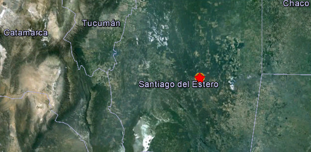
Image credit: Google Earth + USGS
Strong and deep earthquake with recorded magnitude of 6.7 struck Argentina on May 28, 2012 at 05:07 UTC according to USGS. The epicenter was located 52 km (32 miles) NNW of Anatuya, Santiago del Estero, Argentina (28.061°S, 63.077°W). Recorded depth was 588 km (365.4 miles).
Preliminary reports showed 6.4 magnitude, later upgraded to 6.7.
At 11:50 UTC a 5.1 magnitude aftershock struck the same region. Recorded depth was 592 km (367.9 miles).
| Magnitude | 6.7 |
|---|---|
| Date-Time |
|
| Location | 28.061°S, 63.077°W |
| Depth | 588 km (365.4 miles) |
| Region | SANTIAGO DEL ESTERO, ARGENTINA |
| Distances | 52 km (32 miles) NNW of Anatuya, Santiago del Estero, Argentina 117 km (72 miles) ESE of Santiago del Estero, Argentina 249 km (154 miles) SE of San Miguel de Tucuman, Tuc., Argentina 838 km (520 miles) NNW of BUENOS AIRES, D.F., Argentina |
| Location Uncertainty | horizontal +/- 12.9 km (8.0 miles); depth +/- 6.1 km (3.8 miles) |
| Parameters | NST=571, Nph=640, Dmin=601.1 km, Rmss=0.76 sec, Gp= 22°, M-type=”moment” magnitude from initial P wave (tsuboi method) (Mi/Mwp), Version=D |
| Source |
|
| Event ID | usb000a0z0 |

Historic seismicity map

I'm a dedicated researcher, journalist, and editor at The Watchers. With over 20 years of experience in the media industry, I specialize in hard science news, focusing on extreme weather, seismic and volcanic activity, space weather, and astronomy, including near-Earth objects and planetary defense strategies. You can reach me at teo /at/ watchers.news.
[…] Deep Quake Hits Argentina 6.4 http://quakes.globalincidentmap.com/map_detail.php?id=192913 http://www.youtube.com/watch?v=EIAy5HvmoEE&list=UUHE92x768p8h-fMrqhsnE1Q&index=0&feature=plcp http://earthquake-report.com/2012/05/27/complete-earthquakes-list-may-28-2012/ https://watchers.news/2012/05/28/6-4-magnitude-deep-earthquake-struck-santiago-del-estero… Share this:TwitterFacebookLike this:LikeBe the first to like this post. Published: May 28, 2012 Filed Under: Gleaning […]