
M6,3 hit Christchurch, New Zealand
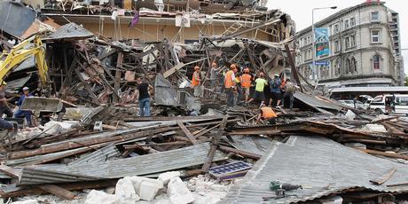
Image credit: TW
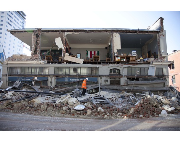
A strong quake hit New Zealand’s second-biggest city of Christchurch on Tuesday for the second time in five months, toppling buildings, causing “multiple fatalities,” trapping people beneath rubble and sparking fires.
Local TV showed bodies being pulled out of rubble strewn around the city center, though it was unclear whether any of them were alive, but police reported multiple fatalities after the 6.3 magnitude quake struck during the busy lunchtime.
Christchurch is built on silt, sand and gravel, with a water table under it. In an earthquake, the water rises, mixing with sand. Unlike last year’s even stronger tremor, which struck early in the morning when streets were virtually empty, the streets, shops and offices in the city of almost 400,000 were thronged with people when the shallow tremor struck.
GALLERY: Magnitude 6.3 earthquake hits Christchurch
It hit at 12:51 pm (2351 GMT Monday) at a depth of only 4 km (2.5 miles), according to the U.S. Geological Survey’s Web site. The tremor was centered about 10 km (six miles) southwest of Christchurch, which had suffered widespread damage during last September’s 7.1 magnitude quake but no deaths.
The region has been struck by thousands of aftershocks since the original quake.
New Zealand, which sits between the Pacific and Indo-Australian tectonic plates, records on average more than 14,000 earthquakes a year, of which about 20 would normally top magnitude 5.0.
New Zealand sits on the so-called “Ring of Fire”, the boundary of the Australian and Pacific tectonic plates, and experiences up to 15,000 tremors a year. It averages at least one a day of magnitude 4.0 or stronger.
Allvoices.com gallery
AboveTopSecret.com gallery
Earthquake causes ice to break off glacier
The earthquake that struck Christchurch has caused some 30 million tons of ice to break off from New Zealand’s biggest glacier. Tour guides at the Tasman Glacier in the Southern Alps say the quake caused the ice to “calve” from the glacier, forming icebergs in the terminal lake. Tourists of Glacier Explorer boats say the icefall caused waves of up to 3.5 meters in height which swept up and down the lake for 30 minutes.
The glacier is about 120 miles (200 kilometers) from Christchurch on the west coast.
Deadly quake could be sign of more to come (NZHerald)
Christchurch quake: Fears 300 dead @ earth issues
Here are somer historic recorded earthquakes in the country:
8.2 – January 23, 1855. Centred in the lower North Island and the most severe quake in New Zealand since European colonisation began in 1840. Thought to have killed seven to nine people.
7.8 – July 16, 2009, only 12 kilometres deep in the remote Fiordland region. No casualties reported.
7.8 – February 3, 1931. Centred in the Hawke’s Bay. Claimed 256 lives in the most damaging of any recorded New Zealand quake.
7.8 – June 17, 1929. In the Buller region on the West Coast of the South island. Some 15 people killed.
7.8 – October 16, 1848. Marlborough region.
7.6 – March 5 1934. Pahiatua in the lower North Island.
7.2 – June 24, 1942. In Wairarapa, lower North Island.
7.1 – May 24, 1968. At Inangahua on West Coast of South Island. Killed three.
7.1 – September 1, 1888. North Canterbury.
7.0 – September 4, 2010. Christchurch. Widespread damage but no deaths.
6.3 – February 22, 2011. Christchurch. Multiple fatalities and extensive damage.
I'm a dedicated researcher, journalist, and editor at The Watchers. With over 20 years of experience in the media industry, I specialize in hard science news, focusing on extreme weather, seismic and volcanic activity, space weather, and astronomy, including near-Earth objects and planetary defense strategies. You can reach me at teo /at/ watchers.news.
Commenting rules and guidelines
We value the thoughts and opinions of our readers and welcome healthy discussions on our website. In order to maintain a respectful and positive community, we ask that all commenters follow these rules.