
Flood Watches cover New Mexico, Utah and Colorado, heavy-rain threat shifts to South Dakota
Another round of heavy showers and thunderstorms was forecast across parts of New Mexico, Utah and Colorado on September 17, 2026, prompting Flood Watches for areas vulnerable to rapid runoff and flash flooding. A moisture-rich disturbance was then expected to move northeast into South Dakota, where the National Weather Service’s Weather Prediction Center (WPC) forecast 51–102 mm (2–4 inches) of rain with locally higher totals.

Satellite image southwest USA at 17:40 UTC on September 17, 2026. Credit: NOAA/GOES-19, Zoom Earth, The Watchers
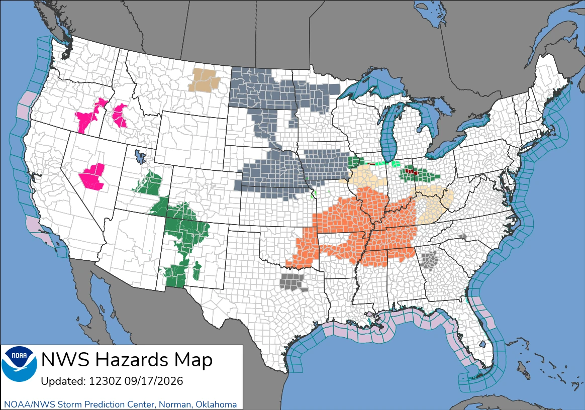
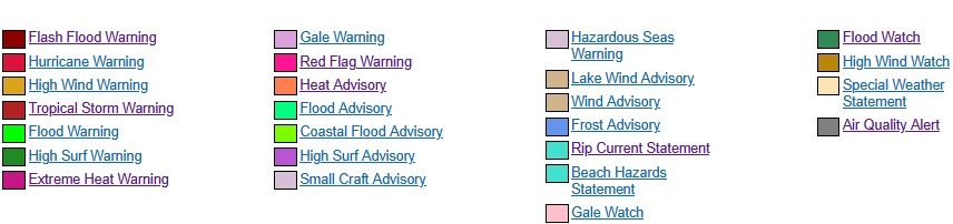
Flood Watches covered parts of New Mexico, Utah, and Colorado on September 17, as additional storms threatened saturated ground, burn scars, dry washes, and slot canyons.
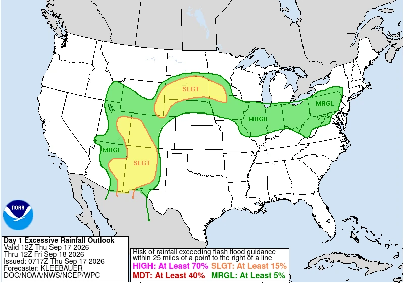
WPC placed a high-end Slight Risk of excessive rainfall across much of South Dakota, where 51–102 mm (2–4 inches), with locally higher totals, was forecast as a tropical-origin disturbance moved out of the Southwest.
The NWS office in Albuquerque issued watches beginning at 11:00 MDT (17:00 UTC) on September 17 for parts of northwestern, north-central, central and west-central New Mexico and the South Central Mountains. The affected areas included Farmington, Shiprock, the Albuquerque and Santa Fe metropolitan areas, the Sangre de Cristo, Jemez and Tusas mountains, the West Central Highlands and burn scars near Ruidoso.
The office said storms could produce rainfall rates of 25–51 mm/h (1–2 inches/h) during the afternoon and evening, followed by lighter to moderate rain overnight. Recent burn scars, urban areas, communities with limited drainage infrastructure, complex terrain, and already saturated ground were particularly vulnerable to rapid runoff.
Additional watches issued by NWS El Paso/Santa Teresa covered Sierra, Doña Ana, Luna and eastern Grant counties and the Sacramento Mountains of northern Otero County from 12:00 MDT (18:00 UTC) on September 17 through 06:00 MDT (12:00 UTC) on September 18.
The office said many areas west of the Rio Grande had received 13–51 mm (0.5–2 inches) of rain over recent days. Localized totals of another 25–51 mm (1–2 inches) were possible where strong storms developed or repeatedly crossed the same area.
In Utah, watches covered the Wasatch Plateau and Book Cliffs, Central Mountains, Castle Country and San Rafael Swell, as well as southeastern Utah, the La Sal and Abajo Mountains, and the Canyonlands and Natural Bridges areas. NWS Salt Lake City forecast rainfall rates of 6–25 mm/h (0.25–1 inch/h), with locally higher rates under the strongest storms. Dry washes, slot canyons, slickrock terrain, and burn scars were among the most exposed locations.
NWS Grand Junction maintained watches across the Animas and San Juan river basins, the Four Corners and Upper Dolores River area, and the San Juan Mountains in southwestern Colorado. Recent rain had saturated the ground, while further storms threatened the Gold Mountain, Elk, and Ferris burn scars and other steep terrain. NWS Pueblo also maintained a watch for the Eastern San Juan Mountains and Upper Rio Grande Valley through the evening.
The main weather system was a compact disturbance containing deep tropical moisture over central Arizona early on September 17. It was forecast to move northeast around the western side of strong high pressure centered over the Lower Mississippi Valley, carrying moisture through the Central Rockies and into the Northern Plains.
Southerly winds were also keeping unusually moist air over the Southwest. WPC placed precipitable water values between the 90th and 99th percentiles for the date across parts of the region. Daytime heating and upslope flow over higher terrain were expected to produce another round of storms capable of heavy rain.
WPC maintained a Slight Risk of excessive rainfall across much of New Mexico, eastern Arizona, eastern Utah and western Colorado. It forecast 25–76 mm (1–3 inches) in parts of the Sangre de Cristo and San Juan mountains and other interior New Mexico terrain. The agency said locally moderate impacts were possible around sensitive Sacramento Mountain burn scars, although the broader outlook remained at the Slight Risk level.
As the disturbance moved into the Northern Plains, atmospheric lift was expected to strengthen, and a developing low-level jet was forecast to draw more moisture northward. WPC said moisture transport from South Dakota into southern Minnesota would approach the 95th–99th percentile for the date, while forecast profiles showed a deep, saturated atmosphere favorable for efficient rainfall production.
Storms were forecast to develop near the Wyoming Front Range during the afternoon and expand northeastward across South Dakota during the evening and overnight. WPC forecast a broad swath of 51–102 mm (2–4 inches), with locally higher totals.
High-resolution ensemble guidance showed a 50–80% probability of more than 51 mm (2 inches) across a large part of the High Plains and much of central and southern South Dakota. Lower probabilities of more than 76 mm (3 inches) were centered east and southeast of Rapid City, including the Badlands area.
WPC therefore maintained a high-end Slight Risk across much of South Dakota, extending west toward eastern Wyoming and east into southwestern Minnesota and northwestern Iowa. A Slight Risk represents at least a 15% chance of rainfall exceeding local flash-flood guidance within 40 km (25 miles) of a point; it does not mean flooding will occur everywhere in the outlined area.
The disturbance was forecast to continue east on September 18. WPC maintained a high-end Slight Risk from southern Minnesota into Wisconsin, where another 51–102 mm (2–4 inches), with locally higher totals, was possible. The greatest concern was south of Interstate 94, including parts of the Minneapolis area, southeastern Minnesota, and western Wisconsin.
The renewed threat followed deadly flooding in northwestern New Mexico. Navajo Nation officials said two adults and a juvenile died after being swept away near Newcomb early on September 16.
References:
1 Flood Watch – NOAA/NWS – September 17, 2026
2 Day 1 Excessive Rainfall Outlook and discussion – NWS/WPC – September 17, 2026

Rishav Kothari is Editor-in-Chief of The Watchers, where he runs the newsroom and covers earthquakes, volcanoes, severe weather and space weather.
