
Strong winter storm over the Southern Plains to evolve into a Nor’easter on February 12
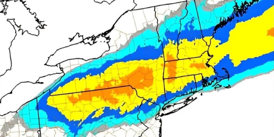
Image credit: NWS/WPC
Forecasters at the National Weather Service (NWS) issued a warning on February 11, 2024, about a significant winter storm impacting the Southern Rockies and High Plains, moving northeast towards the Northern Mid-Atlantic, New York, and New England. Expected heavy snowfall, powerful winds, and potential coastal flooding are set to disrupt travel and cause power outages across affected regions.
Key messages for the February 10 – 13 winter storm:
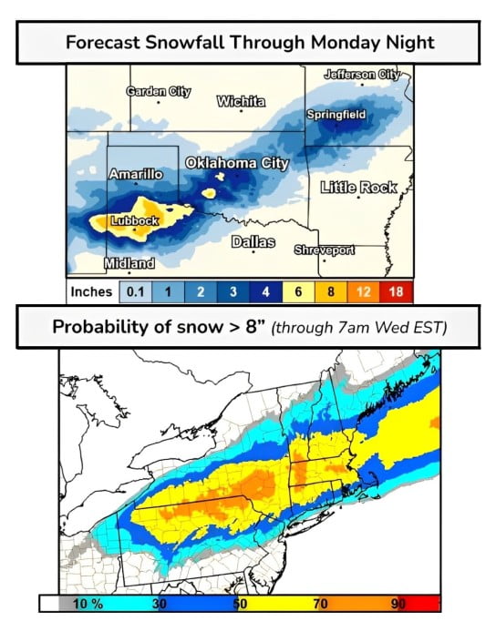
- A winter storm tracking across the southern High Plains will produce a swath of heavy and disruptive snowfall accumulations from the Southern Rockies to central Oklahoma today and into Sunday night. Hazardous travel conditions are expected in affected areas.
- The storm will make its way east into the Mid-South where a band of heavy snow will set up over southern Missouri, with localized snowfall totals up to 150 mm (6 inches) possible in the Ozarks.
- On Monday night, February 12 into Tuesday, February 13, a low pressure in the Ohio Valley will give way to a rapidly deepening storm off the Mid-Atlantic coast. Heavy snowfall will begin across northern Pennsylvania, southern New York, and southern New England early Tuesday morning.
- This fast-moving storm currently has the highest potential for over 205 mm (8 inches) across northern Pennsylvania through southern New England. Powerful winds and heavy/wet snow could damage trees, powerlines, and disrupt travel. Coastal Flooding is also expected.
The National Weather Service (NWS) has warned of a significant winter storm continuing to impact the Southern Rockies and High Plains on February 11, 2024, before heading northeast towards the Northern Mid-Atlantic, New York, and New England early this week.
This weather event is expected to produce a swath of heavy and disruptive snowfall accumulations from the Southern Rockies to central Oklahoma today and into Sunday night, leading to hazardous travel conditions in these areas.
As the storm advances east into the Mid-South, a band of heavy snow is forecasted over southern Missouri, with localized snowfall totals reaching up to 150 mm (6 inches) possible in the Ozarks, exacerbating travel difficulties.
By Monday night into Tuesday, February 13, a low-pressure system in the Ohio Valley will evolve into a rapidly deepening storm off the Mid-Atlantic coast.
This transition will initiate heavy snowfall across northern Pennsylvania, southern New York, and southern New England early Tuesday morning. The regions are bracing for the storm’s peak intensity, with snowfall potential exceeding 205 mm (about 8 inches), alongside powerful winds and heavy, wet snow that could lead to significant tree and powerline damage, as well as travel disruptions. Coastal flooding is also a concern due to the storm’s intensity.
Additional accumulations of 150 to 300 mm (6 to 12 inches) of snow are anticipated for areas of the Texas Panhandle, with the storm’s effects also spreading to Oklahoma due to marginally cold air and moisture. The Gulf Coast states, Mid-South, and Southeast are expecting severe weather, including the risk of strong winds, large hail, and tornadoes, under a Slight Risk warning from the Storm Prediction Center.
The extensive cloud cover and precipitation are likely to result in below-normal temperatures across the South, contrasting with the above-normal temperatures expected across much of the northern and eastern U.S., where the lack of cold air transport from Canada will mitigate the usual cold conditions despite the storm.
References:
1 Key Messages for Feb 10 – 13 Winter Storm – WPC – February 11, 2024
2 Short Range Forecast Discussion – NWS Weather Prediction Center College Park MD – 259 AM EST Sun Feb 11 2024
I'm a dedicated researcher, journalist, and editor at The Watchers. With over 20 years of experience in the media industry, I specialize in hard science news, focusing on extreme weather, seismic and volcanic activity, space weather, and astronomy, including near-Earth objects and planetary defense strategies. You can reach me at teo /at/ watchers.news.
Commenting rules and guidelines
We value the thoughts and opinions of our readers and welcome healthy discussions on our website. In order to maintain a respectful and positive community, we ask that all commenters follow these rules.