
Major storms to produce widespread, significant impacts over much of the U.S.
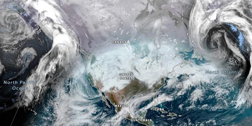
Image credit: NOAA/GOES-East, Zoom Earth, The Watchers. Acquired at 17:50 UTC on January 7, 2024
A strengthening storm is set to impact the Central and Southern U.S., bringing a mix of heavy snow, strong winds, blizzard conditions in the Plains and Midwest, severe thunderstorms across the Gulf Coast, and widespread flooding this week. In addition, a major winter storm will bring several feet of snow to the Washington and Oregon Cascades through Tuesday, January 9, 2024.
The United States is bracing for major storms this week, with forecasters warning of widespread, significant impacts across much of the country. As a deep and dynamic mid-latitude cyclone organizes over the Central/Southern Plains, regions are preparing for a confluence of severe weather conditions.
In the Plains and Midwest, heavy snow is developing and will advance into the area tonight and continue through Tuesday. Residents can expect bursts of heavy snow, with accumulations up to 50 mm (2 inches) per hour, leading to hazardous travel conditions.
A blizzard is particularly expected in the Plains of northeast New Mexico, eastern Colorado, the Oklahoma and Texas Panhandles, western Kansas, and southwest Nebraska, where wind gusts as high as 100 – 112 km/h (60 – 70 mph) will create whiteouts and make travel extremely dangerous to impossible. Those in the area are urged to pack a winter survival kit as wind chills are expected to plummet below zero.
The central Gulf Coast is facing an Enhanced Risk of Severe Thunderstorms tonight into early Tuesday morning. Severe thunderstorms capable of producing strong wind gusts and tornadoes are expected from southeast Texas across the central Gulf Coast this afternoon into early Tuesday morning, shifting into parts of southeastern Alabama, northern Florida, and parts of the Carolina Piedmont/Coastal Plain on Tuesday. The main threats will be very strong and damaging winds as well as a few tornadoes.
Additionally, widespread and potentially significant river and flash flooding are likely for the central Gulf Coast and Eastern U.S. through early Wednesday, January 10. Powerful onshore winds will lead to widespread coastal flooding along the eastern Gulf Coast and much of the East Coast, with significant coastal flooding especially likely on the Mid-Atlantic coastline, including tidal rivers and bays.
Parts of southeast Louisiana, southern Mississippi, and southwestern Alabama are at a Moderate Risk of Excessive Rainfall leading to Flash Flooding today, with this risk shifting into the Mid-Atlantic on Tuesday between northern Virginia, up the I-95 corridor, and into western Massachusetts. The existing snowpack from recent snowstorms may exacerbate runoff concerns in these areas.
Wind gusts in excess of 80 km/h (50 mph) are likely in the eastern Gulf Coast, Central Appalachians, much of the East Coast, and New England, raising the potential for power outages.
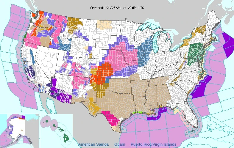
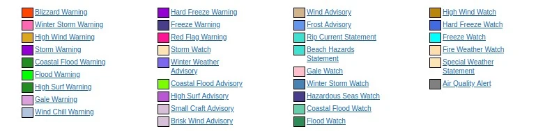
In addition, another pair of powerful winter storm systems will cross the Pacific Northwest tonight and Tuesday night, bringing several feet of heavy snow and strong winds across the Cascades.
Blizzard conditions are likely, with snow levels rising to around 1 500 m (5 000 feet) tonight due to an atmospheric river, but quickly falling to between 450 and 750 m (1 500 and 2 500 feet) behind a cold front on Tuesday, causing considerable impacts for many mountain passes with the second storm Tuesday night. Over 30 cm (1 foot) of snow is highly likely in the higher elevations of the Northern Rockies on Tuesday and Wednesday.
Residents across the affected regions are urged to stay updated with the latest weather forecasts, adhere to safety advisories, and prepare for a range of severe weather conditions.
Read more:
References:
1 Short Range Forecast Discussion – NWS Weather Prediction Center College Park MD – 135 AM EST Mon Jan 08 2024
I'm a dedicated researcher, journalist, and editor at The Watchers. With over 20 years of experience in the media industry, I specialize in hard science news, focusing on extreme weather, seismic and volcanic activity, space weather, and astronomy, including near-Earth objects and planetary defense strategies. You can reach me at teo /at/ watchers.news.
Commenting rules and guidelines
We value the thoughts and opinions of our readers and welcome healthy discussions on our website. In order to maintain a respectful and positive community, we ask that all commenters follow these rules.