
Significant early-season winter storm brings heavy snowfall to portions of the Northwest, Northern Rockies, and Northern Plains
A long-duration, early-season snowstorm began Tuesday afternoon, October 24, 2023, across portions of the Pacific Northwest, Northern Rockies, and Northern High Plains. Moderate to heavy snowfall is forecasted for these locations over the next few days. Heavy snow bands will likely result in hazardous travel conditions and poor visibility.
The storm is currently impacting the Northwest and Northern Rockies and is expected to extend into the Northern Plains. Forecasts indicate snowfall totals of 30 – 50 cm (12 – 20 inches) in the higher terrains of the Cascades and Northern Rockies. Meanwhile, eastern Montana and western North Dakota are preparing for 15 – 30 cm (6 – 12 inches) of snow.
Heavy snowfall rates of 2.5 cm/hr (1 inch/hr) are expected in certain areas, likely leading to snow-covered and icy roads that will make travel challenging.
Following this, a winter blast is forecasted to bring frigid air across the Northern Rockies and Plains. Temperatures are expected to plummet, with daytime highs on Wednesday in Montana ranging between -6 to -2 °C (20s °F). Morning lows on Thursday could drop to -15 to -12 °C (single digits °F). Similarly, Wyoming and the western Dakotas are forecasted to see highs of -6 to 1 °C (20s and 30s °F) by Thursday.
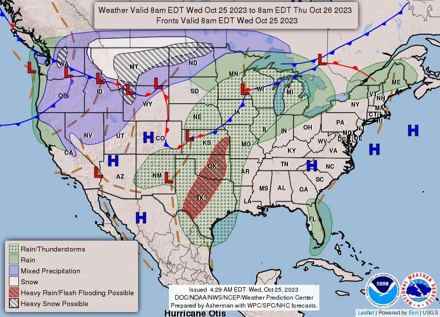
Less severe, but still noteworthy, are the cooler temperatures expected across the Northwest, with forecasts indicating highs between 4 to 11 °C (40s and low 50s). These cooler conditions are predicted to extend into northern California and the Great Basin by Thursday.
In contrast, the Southwest is forecasted to maintain near-average temperatures, with highs of 21 to 27 °C (70s and 80s). Ahead of the cold front, much of the central and eastern U.S. is expected to experience above-average temperatures. Highs are generally forecasted to range from 15 to 21 °C (60s to low 70s) for the Great Lakes and Interior Northeast; 21 to 26 °C (70s) for the Central Plains eastward through the Ohio Valley and into the Northeast; and 26 to 30 °C (80s) for the Southern Plains and Southeast.
Limited rain mixed with snow is expected for the interior Northwest and northern Great Basin, with minimal accumulations forecasted.
References:
1 Short Range Forecast Discussion – NWS Weather Prediction Center College Park MD – 400 AM EDT Wed Oct 25 2023
I'm a dedicated researcher, journalist, and editor at The Watchers. With over 20 years of experience in the media industry, I specialize in hard science news, focusing on extreme weather, seismic and volcanic activity, space weather, and astronomy, including near-Earth objects and planetary defense strategies. You can reach me at teo /at/ watchers.news.
Commenting rules and guidelines
We value the thoughts and opinions of our readers and welcome healthy discussions on our website. In order to maintain a respectful and positive community, we ask that all commenters follow these rules.