
Rare weather event, seen only twice per year, to impact southwest Western Australia
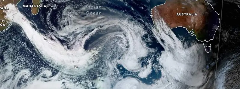
Image credit: EUMETSAT/JMA, Zoom Earth, The Watchers. Acquired at 07:30 UTC on September 12, 2023
A severe cold front is set to impact a vast region of southern Western Australia on September 13, 2023. The event, characterized by strong winds, thunderstorms, and significant rainfall, is expected to be more intense than typical fronts, with such conditions seen only about twice annually.
Southern Western Australia is bracing for an intense cold front, anticipated to bring a range of severe weather conditions. This front, which is forecasted to be windier than usual, is expected to produce weather patterns that are typically observed only a couple of times each year.
The Bureau of Meteorology has issued a Severe Weather Warning, highlighting the potential for widespread damaging winds, especially along the west coast. Some areas might even experience locally destructive winds. With the front’s approach, Perth and much of the southwestern region of the state are forecasted to receive rainfall amounts ranging from 20 to 40 mm (0.8 to 1.6 inches). However, isolated regions, particularly over the Darling Scarp and through the southwest, could witness heavy rainfall, with amounts possibly reaching 60 to 70 mm (2.3 to 2.7 inches).
Accompanying the front, there’s a possibility of severe thunderstorms, which could further escalate the wind conditions, making them damaging to even locally destructive in nature. As a result of the anticipated weather patterns, Elevated Fire Dangers and Fire Weather Warnings have been forecasted for the inland parts of the state for the upcoming Wednesday, September 13.
Coastal regions are also on alert, as large waves are expected to produce hazardous surf conditions. These conditions pose a significant risk for coastal activities, including swimming, surfing, and rock fishing, especially across the south-western parts of Western Australia. These dangerous conditions are expected to persist through Wednesday and Thursday.
Furthermore, the cold, wet, and windy conditions have prompted the issuance of a Sheep Graziers Warning for a significant portion of south-west Western Australia.
However, there’s some relief in sight. The severe conditions are expected to subside rapidly by Thursday, giving way to milder weather in the subsequent days. Some isolated coastal showers might linger, but the intensity is expected to decrease significantly.
Residents and communities are strongly advised to stay informed by regularly checking updates from the Bureau of Meteorology website and the Weather app. It’s also crucial to heed the advice and instructions of emergency services during this period.
References:
1 Severe Weather Warning issued for Western Australia ahead of strong cold front on Wednesday – BOM – September 12, 2023
The Watchers team and our contributors bring the latest on extreme weather, earthquakes, volcanic eruptions, space weather, and all things science. We're all about making sense of the natural world and keeping you informed on what’s happening. Got a tip or a question? Hit us up using the form at newstips!
Commenting rules and guidelines
We value the thoughts and opinions of our readers and welcome healthy discussions on our website. In order to maintain a respectful and positive community, we ask that all commenters follow these rules.