
Powerful storm system to affect large portion of the Intermountain West and Central U.S.
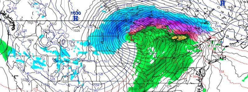
Image credit: GFS, TropicalTidbits. Valid 12:00 UTC on April 5, 2023
A major winter storm will produce multiple weather hazards this upcoming week from the Intermountain West to the Central U.S. that include significant snowfall, blizzard conditions, and damaging wind gusts.
- A major winter storm is likely to produce over 30 cm (1 foot) of snow from the Central Rockies to the Northern Plains, which could challenge some April snow records in the Dakotas and northwest Minnesota, according to the Weather Prediction Center. Avalanches and significant impacts from snow load are possible in the Intermountain West, particularly in portions of Utah.
- Strong winds and heavy snow will create whiteout conditions at times Tuesday and Wednesday, April 4 and 5, causing dangerous to impossible driving conditions and considerable disruption to daily life.
- Wind chills will fall to near or below -18 °C (0 °F) during the blizzard in the Northern Plains, which could be life-threatening to anyone stranded.
- Widespread gusts in excess of 80 km/h (50 mph) will spread from the Southwest and Four Corners Monday, to the Plains Tuesday, and Upper Midwest Wednesday. This may lead to power outages, wind damage, and blowing dust even outside of thunderstorm activity.
A large and powerful storm system is expected to affect the western and central U.S. this week, beginning to strengthen over the Intermountain West on Monday, April 3, 2023, before moving into the central Plains by April 4. The highly anomalous upper-level low is forecasted to swing from the Intermountain West to the Central Rockies on Tuesday, potentially causing the biggest snowstorm of the year across parts of the northern Plains.1
This weather event results from a combination of very cold temperatures and ample atmospheric moisture from the Pacific Ocean, supported by the strong pressure gradient created by the surface low-pressure system. Damaging winds are possible in some areas, while the warm southerly flow to the east of the system will bring spring warmth to the central and eastern U.S. Cold northerly flow will introduce a new round of below-average temperatures across the West, with snowy conditions in the north-central regions.
Severe thunderstorms are also expected throughout the Nation’s Heartland due to the warm airmass in the East clashing with an approaching cold front on Tuesday. Heavy snow is already ongoing in parts of the Northwest, with several additional feet of snow likely across the Oregon Cascades over the next few days as the current wave and next round impact the region on Tuesday.
From tonight into April 3, heavy snow and high winds are anticipated in the Intermountain West and parts of the central/northern Rockies. A few feet of snow is possible across the higher terrain of Utah, Colorado, and Wyoming, with lower elevations also experiencing heavy snowfall amounts up to 30 cm (12 inches). Low snow levels are expected to cause numerous travel hazards due to low visibility and snow-covered roads.
By Monday night into Tuesday, the maturing surface cyclone over the central Plains is predicted to produce blizzard conditions from parts of southeast Wyoming to eastern North Dakota and northern Minnesota, including much of South Dakota and northwest Nebraska. Over 30 cm (12 inches) of snow combined with strong winds could result in dangerous travel conditions and significant disruption to daily life. Wind chills near to below -18 °C (0 °F) during the blizzard may pose life-threatening risks to those stranded outdoors.
Freezing rain is possible from eastern South Dakota through central Minnesota, northern Wisconsin, and northern Michigan. Winter weather headlines (Winter Storm Warnings/Watches and Winter Weather Advisories) extend from Nevada to Minnesota.
The large wind field produced by this system is also expected to impact much of the Southwest and southern High Plains, with wind gusts up to 130 km/h (80 mph) possible from inland areas of Southern California to the southern Rockies on April 3. These wind speeds could pose danger to high-profile vehicles and cause tree damage and power outages. High winds across the central/southern High Plains, combined with low relative humidity, will create critical fire weather conditions. Red Flag Warnings and Fire Weather Watches extend from southern Arizona to central Oklahoma.
References:
1 Short Range Forecast Discussion – NWS Weather Prediction Center College Park MD – 359 AM EDT Sun Apr 02 2023
The Watchers team and our contributors bring the latest on extreme weather, earthquakes, volcanic eruptions, space weather, and all things science. We're all about making sense of the natural world and keeping you informed on what’s happening. Got a tip or a question? Hit us up using the form at newstips!
Commenting rules and guidelines
We value the thoughts and opinions of our readers and welcome healthy discussions on our website. In order to maintain a respectful and positive community, we ask that all commenters follow these rules.