
Tropical Cyclone “Freddy” about to make landfall over Madagascar
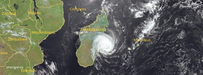
Featured image: Tropical Cyclone "Freddy" at 08:45 UTC on February 21, 2023. Credit: EUMETSAT/Meteosat-9, Zoom Earth, The Watchers
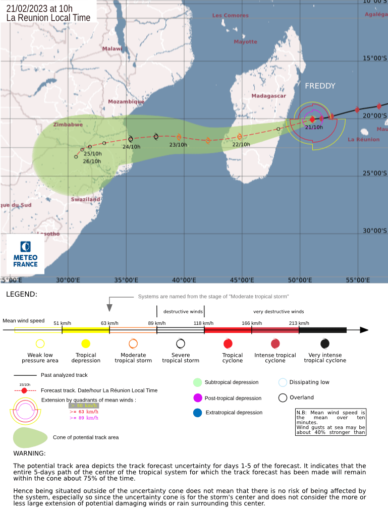
Tropical Cyclone “Freddy” is expected to make landfall between 15:00 and 18:00 UTC on February 21, 2023, over the north of the province of Vatovavy-Fitovinany, Madagascar. After moving over Madagascar, bringing strong winds and heavy rains, the system will exit into the Mozambique Channel, re-intensify, and then make landfall over Mozambique.
- Freddy formed on February 6, 2023, as the fourth named storm of the 2022/23 Australian region cyclone season. The system rapidly intensified and reached category 4 on the Australian scale before entering the South-West Indian Ocean on February 14. It continued to intensify, reaching a peak of 270 km/h (165 mph) on February 15, equivalent to a Category 5 tropical cyclone on the Saffir-Simpson scale.
- After moving over Madagascar, Freddy will re-intensify and head toward Mozambique.
- Once it makes landfall in Mozambique, it will become one of only four systems to traverse the entirety of the southern Indian Ocean from east to west. The others were cyclones Litanne in 1994 and Leon–Eline and Hudah in 2000.
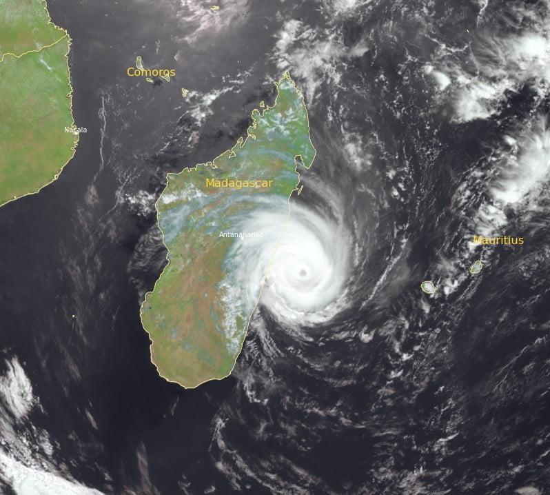
At 06:00 UTC on February 21, the center of Tropical Cyclone “Freddy” was located about 300 km (180 miles) W of Madagascar, 445 km (277 miles) WNW of Réunion, and about 1 020 km (630 miles) SE of Mayotte.
Its maximum 10-minute sustained winds were 150 km/h (90 mph), with gusts up to 220 km/h (140 mph) while maximum 1-minute sustained winds were 195 km/h (120 mph).
The minimum central barometric pressure was 959 hPa and the system was moving W at 30 km/h (18 mph).
During the last 6 hours, the eye configuration has continued to degrade with a very weakened inner eye wall, which suggests a weak eyewall cycle, forecasters at the RSMC La Reunion said in a bulletin released at 06:00 UTC today.
There’s little change in terms of trajectory forecast until landing on Madagascar: Freddy maintains its course towards the west-southwest until Tuesday evening (LT), skirting the northern facade of the high geopotentials of the middle troposphere.
In the short term, the forecasts of the various models remain little dispersed and stable, with a good confidence on a trajectory accelerating it until a landing on Tuesday evening on the Malagasy east coast, at the level of the provinces of Atsinanana and Vatovavy-Fitovinany.
Freddy should maintain at least the upper threshold of a tropical cyclone during its rapid path toward Madagascar. At the end, after a classical weakening over the Malagasy lands, the central core of Freddy should restructure before a re-intensification over the Mozambique Channel in mixed environmental conditions (oceanic potential less rich than over the Indian Ocean basin, and especially a strengthening of the shear in the middle and upper troposphere).
It could however reach the stage of a strong storm before its landing on the coast of Mozambique by Friday, February 24.
According to the CMRS forecast, the cyclone should then weaken significantly over land.
Impacts on inhabited lands during the next 72 hours
Madagascar
- Landfall is expected on Tuesday, February 21 between 15:00 and 18:00 UTC probably over the north of the province of Vatovany-Fitovinany.
- Probable arrival of the gale from Tuesday at 12:00 UTC.
- Very big to huge sea off the coast near the landing zone during the afternoon of Tuesday with waves of 9 to 12 m (29 – 39 feet) and a surge arriving later and may reach 2 m (6.5 feet) locally.
- Intense rain during the next 36 hours, cumulated rainfall could be around 200 mm (7.9 inches) near the impact area.
- When the system crosses the land, the accumulations will remain around 100 mm (3.9 inches) during the episode.
Mozambique
- Landfall is expected on Friday, February 24 early in the day probably between Beira and Maxixe.
- Probable arrival of the gale on the night of Thursday to Friday at the coast.
- Heavy sea near the landing zone during the day on Friday.
- Intense rainfall rapidly spreading inland with accumulations locally exceeding 300 mm (11.8 inches) in 72 hours.
Madagascar is still recovering from the passage of the extremely damaging Tropical Cyclone “Cheneso” in January 2023.
According to the National Office for Risk and Disaster Management (BNGRC), Cheneso left 33 people dead and 20 others missing. The agency also reports a total of 90 870 affected people, 34 100 of which were displaced. Around 23 600 homes and 164 schools suffered damage.
The arrival of Freddy to Mozambique will bring more heavy rains and strong winds to the country already heavily affected by widespread floods.
References:
1 RSMC / Tropical Cyclone Center La Reunion – Tropical Cyclone Forecast Warning (South-West Indian Ocean) #1287/20222023. Intense Tropical Cyclone 7 (Freddy) – 06:00 UTC on February 21, 2023
I'm a dedicated researcher, journalist, and editor at The Watchers. With over 20 years of experience in the media industry, I specialize in hard science news, focusing on extreme weather, seismic and volcanic activity, space weather, and astronomy, including near-Earth objects and planetary defense strategies. You can reach me at teo /at/ watchers.news.
Commenting rules and guidelines
We value the thoughts and opinions of our readers and welcome healthy discussions on our website. In order to maintain a respectful and positive community, we ask that all commenters follow these rules.