
Massive storm to impact the Central and Southern U.S.
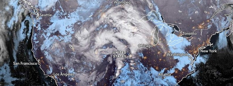
Image credit: NOAA/GOES-East, Zoom Earth, The Watchers. Acquired at 09:20 UTC on December 13, 2022
A massive storm system will impact the Central and Southern U.S. over the next few days. Widespread heavy snow with blizzard conditions and a zone of wintry mix is possible from the north-central High Plains to the Upper Midwest. Meanwhile, in the warm sector of the storm, a severe weather event with all hazards is possible in the southern Plains and Lower Mississippi Valley to Florida.
A deep, closed low over the West will progress slowly eastward over the Plains through December 15, 2022, NWS forecaster Putnam noted.1
A strong, embedded vort max ejecting over the High Plains as upper-level heights continue to fall ahead of the approaching closed low has led to a deepening surface cyclone in the lee of the Rockies.
This storm system will continue to produce numerous, widespread, and impactful weather hazards from the Rockies to the East Coast, Putnam said, adding that both flash flooding and severe weather will be a risk from the Southern Plains east into the Lower Mississippi Valley and Southeast in the warm sector of the system.
Anomalously high moisture for December will flow northward from the Gulf ahead of a cold front sweeping eastward.
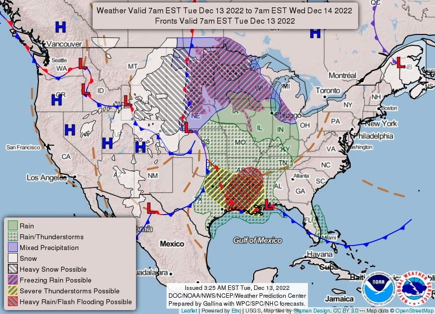
Increasing shear and cooling air aloft will provide the necessary ingredients for a line of intense convection to continue along the front as thunderstorms, including supercells, develop ahead of the front.
There is a Slight Risk of Excessive Rainfall (level 2/4) centered on the Lower Mississippi Valley Tuesday, December 13 as a couple of rounds of rainfall between the initial supercells and a convective line will produce rainfall totals between 25 and 50 mm (1 – 2 inches), with localized areas of 50 and 100+ mm (2 – 4+ inches) leading to some scattered instances of flash flooding.
In addition, there is an Enhanced Risk of severe weather (level 3/5) from the Storm Prediction Center for east-central Texas through northern Louisiana into southwest Mississippi, Putnam said.
Sufficient CAPE combined with strong low-level and upper-level shear will be present for any initial supercells ahead of the line as well as embedded within the line to carry the risk for severe hail, winds, and tornadoes, including the potential for a couple strong tornadoes.
A broader Slight Risk (level 2/5) is in place for eastern Texas, southern Arkansas, Louisiana, and southwestern Mississippi.
The threat will remain similar while shifting eastward on Wednesday, December 14.
There is a Slight Risk of Excessive Rainfall from the Lower Mississippi Valley northeastward into the Southeast, Tennessee Valley, and southern Appalachians.
The tendency for heavy downpours within an expanding area of convection to move parallel to the northeast-southwest oriented front will prolong rainfall duration and lead to widespread rainfall of 50+ mm (2+ inches), locally 100+ m (4+ inches), and the potential for scattered instances of flash flooding.
There is also an Enhanced Risk of severe weather along the central Gulf Coast as storms will continue to have the potential to produce severe hail, winds, and tornadoes, including strong tornadoes.
Meanwhile, frigidly cold air will continue to surge southward on the backside of the low as warm air aloft surges northward leading to widespread wintry precipitation and heavy snow for portions of the Northern and Central Plains and Upper Midwest.
Snow accumulations through Wednesday morning will generally range between 250 – 460 mm (10 – 18 inches), centered on the Northern High Plains.
The highest snow totals are currently forecast for western South Dakota, eastern Wyoming, and northwestern Nebraska, where upwards of 610+ mm (24+ inches) will possible.
Gusty winds upwards of 65 – 80 km/h (40 – 50 mph) will accompany a tightening pressure gradient tightens east of the Rockies with the deepening surface cyclone, leading to widespread blizzard conditions and significant travel impacts across the High Plains.
Farther east, accumulating sleet and ice are also expected for portions of the eastern Dakotas into the Upper Midwest.
The current risk for the greatest ice accumulation is for northeastern South Dakota, southwestern Minnesota, and northwestern Iowa where Ice Storm Warnings remain in effect through Tuesday afternoon for totals between 7 and 10 mm (3 to 4 tenths of an inch) of ice and the potential for isolated power outages.
Additional accumulations over 2.5 mm (1/10 of an inch) remain possible for the eastern Dakotas, southern Minnesota, and into central Wisconsin.
Some locations in the Dakotas in particular will likely see both accumulating ice and snow.
Up to 10 mm (4/10 inch) of sleet may also fall in the aforementioned areas.
Ice Storm Warnings are in effect for parts of far northeastern South Dakota.
“Temperatures will be in the teens and 20s [°F] for the Northern and Central High Plains and drop from the 50s Tuesday into the 40s Wednesday for the Central and Southern Plains,” Putnam said.
The wintry precipitation will begin to spread eastward over the Upper Great Lakes late Tuesday and Wednesday and into the Northeast late Wednesday as the storm system continues eastward.
Warm air flowing northward ahead of the system will make the movement of the rain/snow line hard to pin down over the Great Lakes, and subsequently how long snow will fall and how high the totals may be.
Currently, the most confidence for higher snow totals is for northern Wisconsin and the Upper Peninsula of Michigan where temperatures should remain colder closer to the track of the surface cyclone and 100 – 200 mm (4 – 8 inches), locally higher, will be possible.
The threat will expand into the Northeast and late Wednesday as snow begins for portions of the Interior Northeast with freezing rain likely for the central Appalachians.
The wintry precipitation will continue into Thursday, though initial accumulations upwards of 2.5mm (1/10 inch) look possible late Wednesday night through early Thursday morning.
Temperatures immediately ahead of the system will trend 5 – 10 °C (10 – 20 °F) above average from the Plains to the Lower Great Lakes, Ohio and Tennessee Valleys, and the Southeast as an upper-level ridge shifts eastward between the closed low to the west and another to the northeast over the Canadian Maritimes.
Snow will continue in the west under the influence of the upper-level trough, with some additional accumulations for the Northern and Central Rockies.
Temperatures will remain 10 – 20 °F [5 – 10 °C] below average for this time of year, with highs ranging from the 20s and 30s [-6 and ~4°C] for the Great Basin and Northern and Central Rockies, 40s [4 – 10 °C] for the Pacific Northwest and Southern Rockies, and 50s for [10 – 15 °C] California and the Southwest.
An enormous cross-country storm that will unleash blizzard conditions in the northern United States and potentially trigger a severe weather outbreak in the South this week also has its sights set on the Northeast, AccuWeather senior meteorologist Alex Sosnowski said.2
AccuWeather meteorologists expect the enormous storm to create a spinoff system near the Atlantic coast that is likely to bury some locations of the interior Northeast with 300 mm (1 foot) or more of snow later this week as well as trigger areas of icy conditions and coastal flooding.
References:
1 Short Range Forecast Discussion – NWS Weather Prediction Center College Park MD – 326 AM EST Tue Dec 13 2022
2 Major snowstorm brewing for northeastern US – AccuWeather – December 12, 2022
I'm a dedicated researcher, journalist, and editor at The Watchers. With over 20 years of experience in the media industry, I specialize in hard science news, focusing on extreme weather, seismic and volcanic activity, space weather, and astronomy, including near-Earth objects and planetary defense strategies. You can reach me at teo /at/ watchers.news.
Commenting rules and guidelines
We value the thoughts and opinions of our readers and welcome healthy discussions on our website. In order to maintain a respectful and positive community, we ask that all commenters follow these rules.