
Tropical Storm “Agatha” forms, forecast to rapidly intensify into a hurricane and make landfall over southern Mexico
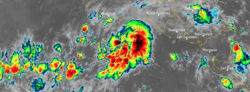
Featured image: Tropical Storm "Agatha" at 11:50 UTC on May 28, 2022. Credit: NOAA/GOES-East, RAMMB/CIRA, TW
Tropical Storm “Agatha” formed on May 28, 2022, as the first named storm of the 2022 Pacific hurricane season. A steady to rapid intensification is forecast and Agatha is expected to become a hurricane on May 29 and make landfall over southern Mexico on May 30.
- There is an increasing risk of tropical-storm-force and hurricane-force winds along portions of the southern coast of Mexico in the next two to three days, and a Hurricane Watch is now in effect for portions of this area. Interests in this area should closely monitor the progress of this system and updates to the forecast, NHC said.
- Heavy rains associated with Agatha will develop over portions of southern Mexico by Sunday and continue through Tuesday, May 31. This will pose a threat of potentially life-threatening flash flooding and mudslides.
- Storm surge could produce coastal flooding near and to the east of where the center passes the coast in areas of onshore winds. The surge may be accompanied by large and destructive waves.
At 12:00 UTC on May 28, the center of Tropical Storm “Agatha” was located about 355 km (220 miles) SSW of Puerto Angel, Mexico.1
Agatha’s maximum sustained winds were 75 km/h (45 mph), with gusts up to 85 km/h (50 mph). The minimum barometric pressure was 1 002, and the system was moving W at 7 km/h (5 mph).
Tropical-storm-force winds were extending outward up to 55 km (35 miles) from the center of Agatha.
A turn toward the northwest is expected later today, followed by a turn toward the northeast by Sunday, May 29.
On the forecast track, the center of Agatha will approach the southern coast of Mexico on Sunday and make landfall there on Monday, May 30.
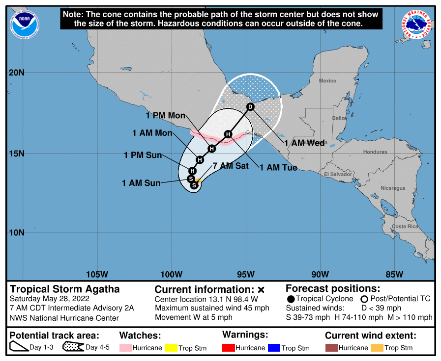
A Hurricane Watch is currently in effect for the southern coast of Mexico from Salina Cruz to Punta Maldonado, Mexico.
A Hurricane Watch means that hurricane conditions are possible within the watch area. A watch is typically issued 48 hours before the anticipated first occurrence of tropical-storm-force winds, conditions that make outside preparations difficult or dangerous. Interests elsewhere in southern Mexico should closely monitor the progress of Agatha.
Additional watches and warnings will likely be required for portions of this area later today.
Agatha is expected to be in a moist environment with light wind shear, significant upper-level divergence, and warm sea surface temperatures until landfall, NHC forecasts Beven and Bucci noted.2
This should allow steady to rapid strengthening, and the SHIPS model rapid intensification index shows a 70% chance of the storm strengthening 55 kt (102 km/h; 63 mph) during the next 48 h.
The intensity forecast thus calls for the cyclone to strengthen to a possibly conservative peak intensity of 85 kt (157 km/h; 98 mph).
There is a possibility that the remnants of Agatha could emerge over the Bay of Campeche by June 2, but at this time it appears unlikely the system will still be a tropical cyclone.
References:
1 Tropical Storm Agatha – Intermediate Advisory Number 2A – NWS National Hurricane Center Miami FL EP012022 – 700 AM CDT Sat May 28 2022
2 Tropical Storm Agatha – Discussion Number 2 – NWS National Hurricane Center Miami FL EP012022 – 400 AM CDT Sat May 28 2022
I'm a dedicated researcher, journalist, and editor at The Watchers. With over 20 years of experience in the media industry, I specialize in hard science news, focusing on extreme weather, seismic and volcanic activity, space weather, and astronomy, including near-Earth objects and planetary defense strategies. You can reach me at teo /at/ watchers.news.
Commenting rules and guidelines
We value the thoughts and opinions of our readers and welcome healthy discussions on our website. In order to maintain a respectful and positive community, we ask that all commenters follow these rules.