
Another glacial outburst flood begins at the Vatnajökull ice cap, Iceland
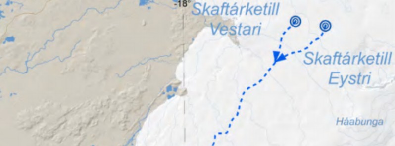
Image credit: IMO
Another glacial outburst flood (jökulhlaup) is in progress at the Vatnajökull ice cap since September 5, 2021. Yesterday's flood started at the Eastern Skaftárketill cauldron and follows another flood from the Western Skaftárketill which began on September 1. This will significantly add to current flood levels in the Skaftá river, the Icelandic Met Office (IMO) said.
Björn Oddsson, a geophysicist for the Department of Civil Protection and Emergency Management, told the mbl.is that the floodwater can be expected to reach the Ring Road tonight, September 6.1
"The people who live here and travel in this area know precisely where the Skaftá glacial outburst floods have an effect. Roads in the area could close, and a great deal of silt and mud could spread around the area and be carried with the wind once the area dries."
Measurements show the surface of the cauldron has subsided 1 m (3.3 feet) between 23:00 UTC on September 4 and 12:45 UTC on September 5.
Maximum discharge during floods from the Eastern cauldron has previously reached 3 000 m3/s (106 000 feet3 per second) but the last flood in 2018 peaked at 2 000 m3/s (70 600 feet3 per second). If compared to the flood in 2018 the first hydrological station will see the first signs of floodwater in the morning of September 6.
The event follows another glacier outburst flood from the Western Skaftárketill which began on September 1.2
A flood from the eastern cauldron has not occurred since 2018, and this one is expected to be about as large as that year’s flood. The flood in 2015 was considerably larger and caused more damage.
Glacial outbursts in the Skaftá river originate in a geothermal area under depressions in the ice cap of the Vatnajökull glacier called Skaftárkatlar. These depressions are formed when geothermal heat melts enough ice to create an outburst flood.
When the outburst takes place, the meltwater first flows a distance of 40 km (25 miles) under the ice cap and then a distance of 28 km (17 miles) along the river bed of Skaftá river, before reaching Sveinstindur mountain. It then takes about 10 hours for floodwaters to reach the Ring Road near Ásar by Eldvatn lake.
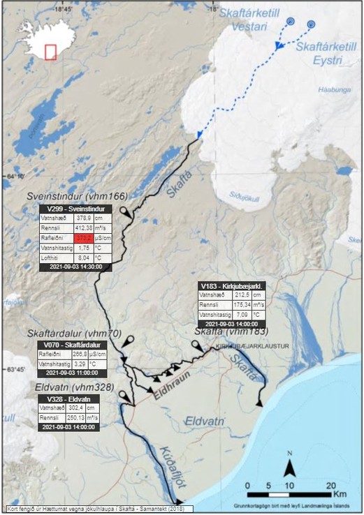
Image credit: IMO
Possible hazards
It is important that locals and people traveling in the area are aware of possible hazards3 and conditions there:
- In the next few days, it is possible that Skaftá will overflow roads that lie close to the river's pathway.
- High values of H2S are expected near the margin of Skaftárjökul and people are advised to stay at a safe distance from the river and the margins of nearby glaciers.
- Crevasses will form rapidly around the cauldron, therefore people traveling on Vatnajökull ice-cap should stay away from the cauldrons and margins of glaciers where floodwater is emerging.
Grímsvötn volcano
On September 30, 2020, IMO raised the Aviation Color Code for Grímsvötn volcano (located beneath the Vatnajökull icecap) due to increasing activity.4
While the Aviation Color Code Yellow does not mean that an eruption is imminent, an eruption could be triggered by depressurization if the subglacial lake inside the caldera will drain and cause a flood or occur regardless, possibly with very weak precursory activity and short warning time, as seen in the eruption of 2011.
On June 15, 2020, IMO announced Grímsvötn volcano is showing strong signs that an eruption might occur in the weeks or months ahead.
According to Melissa Anne Pfeffer, IMO's atmospheric volcanologist, high levels of magmatic gasses were present at the time in the southwest corner of the volcano, near the place where it erupted in 2004 and 2011.
"This is the first time that we measure so much SO2 at a volcano in Iceland that is not in an eruptive phase and its presence is indicative of magma at a shallow level," Pfeffer said in June 2020.
In addition, the volcano was experiencing inflation, indicating an increase in magma.
Grímsvötn's last eruption started at approximately 17:30 UTC on May 21, 2011, with a plume of volcanic ash and steam rising to about 20 kilometers (65 600 feet) above sea level. Overnight, the plume height dropped to 15 kilometers (49 000 feet), but occasionally re-approached the initial altitude.
References:
1 Another Glacial Outburst Flood Begins: Roads Could Close – mbl.is
2 Glacial Outburst Flood in Skaftá River – mbl.is
3 Glacier outburst flood in Skaftá river. Civil protection's alert phase in force – IMO
4 Grímsvötn volcano Aviation Color Code raised from Green to Yellow, Iceland – The Watchers
The Watchers team and our contributors bring the latest on extreme weather, earthquakes, volcanic eruptions, space weather, and all things science. We're all about making sense of the natural world and keeping you informed on what’s happening. Got a tip or a question? Hit us up using the form at newstips!
Commenting rules and guidelines
We value the thoughts and opinions of our readers and welcome healthy discussions on our website. In order to maintain a respectful and positive community, we ask that all commenters follow these rules.