
Hurricane “Grace” strengthening on its way toward mainland Mexico
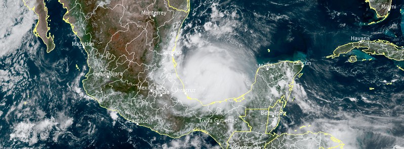
Featured image: Hurricane "Grace" at 16:40 UTC on August 20, 2021. Credit: NOAA/GOES-East, RAMMB/CIRA, TW
Hurricane "Grace" is strengthening on its way toward mainland Mexico. A Hurricane Warning is in effect for the coast of mainland Mexico from north of Cabo Rojo to Barra del Tordo. Landfall is expected within the warning area this evening or tonight, August 21, 2021 — preparations to protect life and property should be rushed to competition.
- Dangerous storm surge is expected to raise water levels by as much as 1.2 – 1.8 m (4 to 6 feet) above normal tide levels. Heavy rainfall is forecast over Veracruz, Puebla, Tlaxcala, Hidalgo, northern Queretaro, and eastern San Luis Potosi, resulting in areas of flash and urban flooding as well as landslides.
- Grace is could become a 160 km/h (100 mph) hurricane within 12h — Category 2. Rapid weakening is expected as it moves over the mountains of central Mexico. Its remnants will likely move into the eastern Pacific and lead to the development of a new tropical cyclone later this weekend or early next week.
At 15:00 UTC on August 20, the center of Grace was located about 325 km (200 miles) E of Tuxpan and 250 km (155 miles) NE of Veracruz, Mexico, according to the NHC.
The system had maximum sustained winds of 140 km/h (85 mph) and was moving W at 22 km/h (14 mph). Its minimum central pressure was 982 hPa.
This general motion at a slightly slower forward speed is expected during the next day or so.
On the forecast track, Grace is forecast to move across the southwestern Gulf of Mexico this afternoon, and make landfall along the coast of mainland Mexico within the hurricane warning area this evening or tonight.1
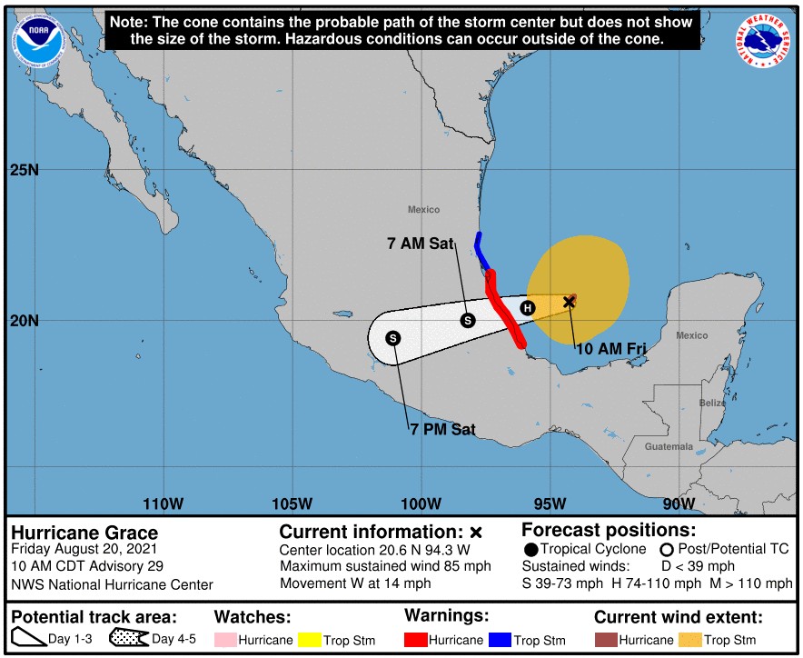
Strengthening is forecast until Grace makes landfall, with rapid weakening expected as it moves inland over the mountains of central Mexico.
A dangerous storm surge will raise water levels by as much as 1.2 – 1.8 m (4 to 6 feet) above normal tide levels along the immediate coast within the hurricane warning area near and north of where the center makes landfall tonight. Near the coast, the surge will be accompanied by large and destructive waves, NHC said.
Veracruz, Puebla, Tlaxcala, Hidalgo, northern Queretaro, and eastern San Luis Potosi can expect 150 to 300 mm (6 to 12 inches) with isolated maximum totals of 460 mm (18 inches) are expected today through Sunday. Heavy rainfall from Grace will result in areas of flash and urban flooding as well as mudslides.
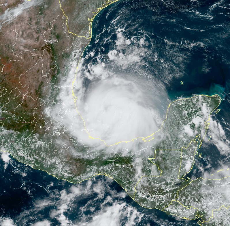
Hurricane "Grace" at 16:40 UTC on August 20, 2021. Credit: NOAA/GOES-East, RAMMB/CIRA, TW
High surf generated by Grace will affect the southern Gulf of Mexico coastline today and continue into the weekend. These swells are likely to cause life-threatening surf and rip current conditions.
"Grace is now forecast to become a 90-kt [160 km/h / 100 mph] hurricane in 12h, which lies on the high end of the intensity guidance," NHC forecasters Reinhart and Canglianosi noted at 15:00 UTC.2
"The center of Grace will be well inland by 24h, and rapid weakening is forecast thereafter as the cyclone moves over the mountains of central Mexico. Although Grace is forecast to dissipate by 48h, its remnants will likely move into the eastern Pacific and lead to the development of a new tropical cyclone later this weekend or early next week."
References:
1 BULLETIN – Hurricane Grace Advisory Number 29 – NWS National Hurricane Center Miami FL- AL072021 1000 AM CDT Fri Aug 20 2021
2 Hurricane Grace Discussion Number 29 – NWS National Hurricane Center Miami FL – AL072021 1000 AM CDT Fri Aug 20 2021
I'm a dedicated researcher, journalist, and editor at The Watchers. With over 20 years of experience in the media industry, I specialize in hard science news, focusing on extreme weather, seismic and volcanic activity, space weather, and astronomy, including near-Earth objects and planetary defense strategies. You can reach me at teo /at/ watchers.news.
Commenting rules and guidelines
We value the thoughts and opinions of our readers and welcome healthy discussions on our website. In order to maintain a respectful and positive community, we ask that all commenters follow these rules.