
Henri expected to strengthen into a hurricane today, make landfall in Long Island or southern New England
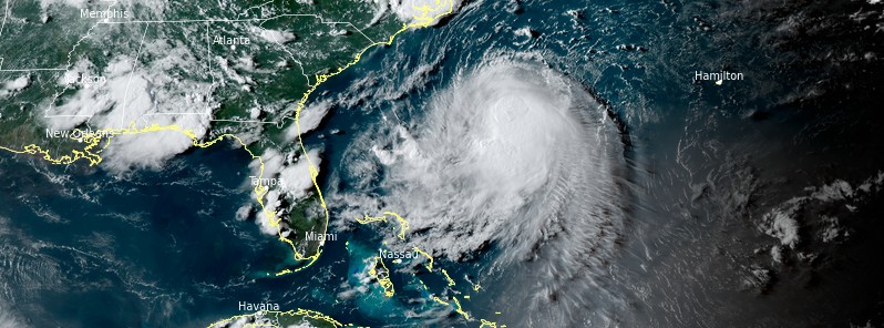
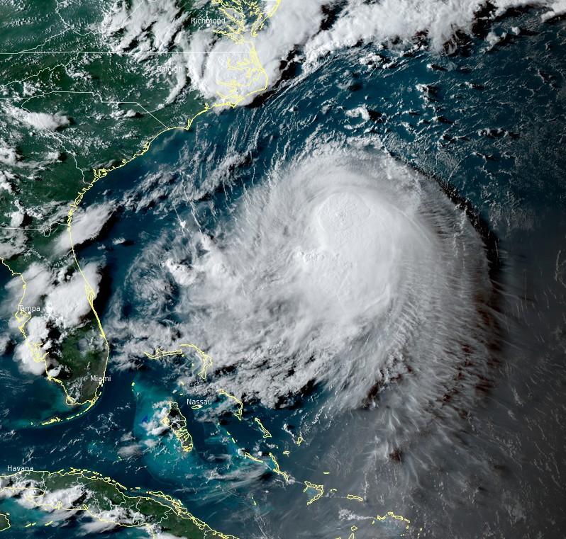
Featured image: Tropical Storm "Henri" at 22:00 UTC on August 21, 2012. Credit: NOAA/GOES-East, RAMMB/CIRA, TW
Tropical Storm "Henri" is expected to become a hurricane on Saturday, August 21, 2021, and make landfall in Long Island or southern New England late Saturday night or on Sunday (LT), August 22.
At 06:00 UTC on August 21, Henri's center was located about 370 km (230 miles) SSE of Cape Hatteras, North Carolina, and 975 km (605 miles) S of Montauk Point, New York.
Its maximum sustained winds were 110 km/h (70 mph) and was moving NW 15 km/h (9 mph). The minimum central pressure was 996 hPa.
A northward to north-northeastward motion is expected today, with a turn toward the north-northwest expected late today or tonight, according to the NHC.1
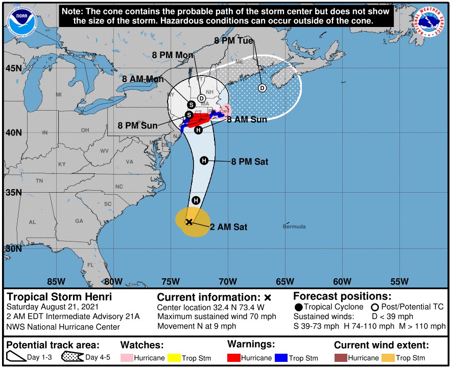
On the forecast track, Henri is expected to make landfall in Long Island or southern New England late Saturday night or on Sunday.
Strengthening is forecast during the next 24 hours, and Henri is expected to become a hurricane today and be at or near hurricane strength when it makes landfall, NHC said.
Tropical Storm "Henri" at 22:00 UTC on August 21, 2012. Credit: NOAA/GOES-East, RAMMB/CIRA, TW
A Storm Surge Warning is in effect for:
- South shore of Long Island from Mastic Beach to Montauk Point, New York
- North shore of Long Island from Montauk Point to Flushing New York
- Flushing New York to Chatham, Massachusetts
- Nantucket, Martha's Vineyard, and Block Island
A Storm Surge Watch is in effect for:
- East Rockaway Inlet to Mastic, New York
- North of Chatham Massachusetts to Sagamore Beach, Massachusetts
- Cape Cod Bay
A Hurricane Warning is in effect for:
- South shore of Long Island from Fire Island Inlet to Montauk Point
- North shore of Long Island from Port Jefferson Harbor to Montauk Point
- New Haven Connecticut to west of Watch Hill Rhode Island
A Hurricane Watch is in effect for:
- Watch Hill Rhode Island to Sagamore Beach, Massachusetts
- Nantucket, Martha's Vineyard, and Block Island
A Tropical Storm Warning is in effect for:
- Port Jefferson Harbor to west of New Haven Connecticut
- South shore of Long Island from west of Fire Island Inlet to East Rockaway Inlet
- Watch Hill Rhode Island to Woods Hole Massachusetts including Block Island and Martha's Vineyard.
- Coastal New York and New Jersey west of East Rockaway Inlet to Manasquan Inlet, including New York City
Dangerous storm surge inundation is expected to begin late Saturday night or Sunday in portions of Long Island, Connecticut, Rhode Island, and southeastern Massachusetts, where a Storm Surge Warning has been issued. Dangerous storm surge is possible beginning late Saturday night or Sunday in western portions of Long Island and Connecticut in the Storm Surge Watch area. Residents in these areas should follow any advice given by local officials, NHC said.
Hurricane conditions are expected to begin late Saturday night or Sunday in portions of Long Island and Connecticut, where a Hurricane Warning has been issued. Hurricane conditions are possible late Saturday night or Sunday across portions of Rhode Island and southeastern Massachusetts.
Heavy rainfall may lead to considerable flash, urban, and small stream flooding, along with the potential for widespread minor and isolated moderate river flooding, over portions of Long Island and New England Sunday into Monday.
Swells from Henri will continue to affect much of the east coast of the U.S. through the weekend. These swells could cause life-threatening surf and rip currents.
References:
1 BULLETIN Tropical Storm Henri Intermediate Advisory Number 21A – NWS National Hurricane Center Miami FL – AL082021 200 AM EDT Sat Aug 21 2021
I'm a dedicated researcher, journalist, and editor at The Watchers. With over 20 years of experience in the media industry, I specialize in hard science news, focusing on extreme weather, seismic and volcanic activity, space weather, and astronomy, including near-Earth objects and planetary defense strategies. You can reach me at teo /at/ watchers.news.
Commenting rules and guidelines
We value the thoughts and opinions of our readers and welcome healthy discussions on our website. In order to maintain a respectful and positive community, we ask that all commenters follow these rules.