
Major winter storm described by NWS as ‘historic and crippling’ slams U.S.
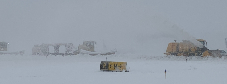
Image credit: Denver International Airport
A major winter storm described by the National Weather Service (NWS) as "historic and crippling" lashed parts of the U.S., bringing up to 1.2 m (4 feet) of snow over the weekend. More than 2 000 flights were canceled and over 54 000 customers were left without power on Sunday, March 14, 2021.
The NWS initially warned of a "historic and crippling" winter storm that will significantly impact all of southeast Wyoming and western Nebraska panhandle, adding that "widespread blizzard conditions" would make travel "dangerous or impossible."
The storm rolled into parts of the Rocky Mountains late Saturday, March 13, dropping heavy snow and rain.
Up to 61.2 cm (24.1 inches) of snow was registered in Denver, Colorado on Sunday, making it the city's fourth-largest snowstorm since 1881. The previous 4th strongest snowfall record was 60.4 cm (23.8 inches) set in December 1982. This was also Denver's largest snowstorm since 2006.
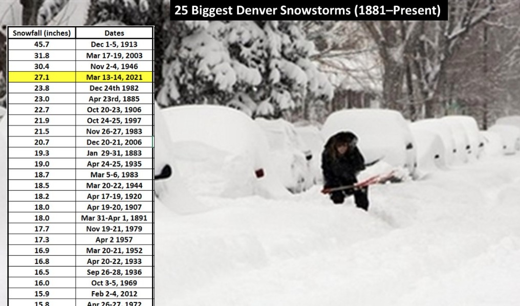
Image credit: NWS Colorado
As of Sunday afternoon, more than 54 000 customers were without power in northern Colorado counties, including the Denver metro area.
It knocked out power to tens of thousands of people, stranded motorists on roads, shut down major roadways and prompted closures of many schools and government offices on Monday, March 15.
The Denver International Airport canceled some 2 000 flights due to difficulties involving airport personnel in getting into work because of the severe weather.
Blizzard conditions continue at the airport. Airlines have ceased operations at DEN for the rest of the day. Peña Blvd is currently impassable with multiple disabled vehicles along the roadways, if you absolutely must come to the airport, please use the @RideRTD A-Line instead pic.twitter.com/uEnXERcDDd
— Denver Int'l Airport (@DENAirport) March 14, 2021
5 AM 3/15 – The main part of the storm has passed, but we still have chances for snow across SE WY & W NE today-Tues morn. 1-2" expected (3" possible @ higher elevations). Travel across WY & NE will still be dangerous as the roads are slick & snow-covered! #WYwx #NEwx #wyoroad pic.twitter.com/hgIhHXNB1X
— NWS Cheyenne (@NWSCheyenne) March 15, 2021
The drifts are really high in some areas. For your safety, please stay home. pic.twitter.com/RhquexDqG6
— NSP Troop E (@NSP_TroopE) March 15, 2021
8:00 a.m. UPDATE: EXTREME traffic and ice remain on I-40 with multiple crashes and slide-offs.
-I-40 EB closed, MP 146.
-I-40 EB, left lane closed, MP 133.
-I-40 WB, left lane closed, MP 174.
ADOT crews are working as quickly as possible. No estimate on reopening.#aztraffic pic.twitter.com/aCpt4kbUEG— Arizona DOT (@ArizonaDOT) March 14, 2021
A powerful winter storm pummeled parts of the U.S. Rockies and western plains, forcing the cancellation of hundreds of flights in Denver and shutting down major highways https://t.co/IzvaY28amT pic.twitter.com/mI1rZJM6Ue
— Reuters (@Reuters) March 15, 2021
"This has definitely been a historic storm," said Alan Reppert, senior meteorologist with AccuWeather. "Definitely something that we can thankfully look at as a very rare occurrence."
In Wyoming, the storm brought wind gusts of up to 88 km/h (55 mph) and heavy snow, closing several parts of I-80 and 8-25. Officials reported that snowplows and emergency vehicles were being hemmed by strong winds and drifts.
At least 25.8 cm (10.2 inches) of snow fell in Cheyenne, breaking the record for the heaviest 2-day snowfall. According to NWS Cheyenne, the previous record was 9.9 cm (25.2 inches) set in November 1979.
United Airlines suspended all weekend flights out of Cheyenne Regional Airport, where more than 53 cm (21 cm) of snow was reported.
Travelers were stranded for hours on I-40 in Arizona after parts of the road were closed due to several crashes. In Nebraska, I-80 westbound was shut at North Platte exits 177 and 179.
Blizzard remnants shift away from the Rockies
"A large and energetic low pressure system enveloping the mid-section of the country is showing signs of winding down after delivering one to two feet of snow to the central High Plains with higher amounts along the Front Range," NWS forecaster Kong noted.
Blizzard conditions in parts of the area have since subsided as the storm center slowly makes its way eastward into the central Plains. Nevertheless, a band of moderate snow with some mixed precipitation is moving across the Midwest and should reach the upper Midwest and lower Michigan by tonight.
Some mixed precipitation should also move into the central Appalachians tonight well ahead of the weakening system.
Areas of heavy snow are also expected in northern California and southeast Alaska.
What happens when all that snow suddenly starts to melt in regions that have been deforested due to fire?
About that low pressure system Julie, D.E.W. has been watching it collect volcanic ash and dust:
https://www.youtube.com/watch?v=FJr2UMCc4Hw
Thanks. I’ve been looking for information on this but there’s nothing on mainstream.
The weather in 2021 is weird. I live in a northern eastern state. The last three weeks have been unseasonably warm. Next week we’re to be in the 60s, 20 degree above average.