
Hurricane “Isaias” makes historic landfall in North Carolina, U.S.
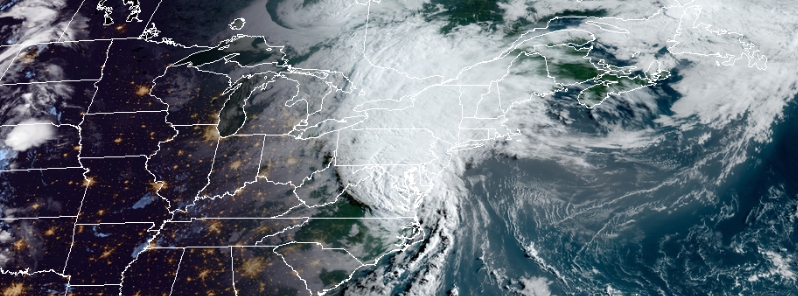
Image credit: NOAA/GOES-East, RAMMB/CIRA. Acquired 11:40 UTC on August 4.
Hurricane "Isaias" made landfall in North Carolina at around 03:10 UTC on August 4, 2020, with winds reaching 137 km/h (85 mph), making it a Category 1 hurricane. This is the first hurricane to make landfall in North Carolina during the month of August since 2011 Irene.
The storm caused flooding and sparked five home fires in Ocean Isle Beach, mayor Debbie Smith told the media.
Nearly 245 000 customers lost power as heavy rains and winds downed trees and power lines in several areas, including Wrightsville, Kure, and Carolina beaches in Wilmington, North Carolina.
Favorable conditions prompted numerous tornado warnings, with two tornadoes touching down and causing damage– the first in Bald Head Island, while the other near Windsor. Another intense and destructive tornado hit near Chowan University.
As the storm neared the shore of Myrtle Beach, a gauge recorded its third-highest tide since it was set up in 1976. Notably, only hurricanes Hugo in 1989 and Matthew in 2016 generated more saltwater inland.
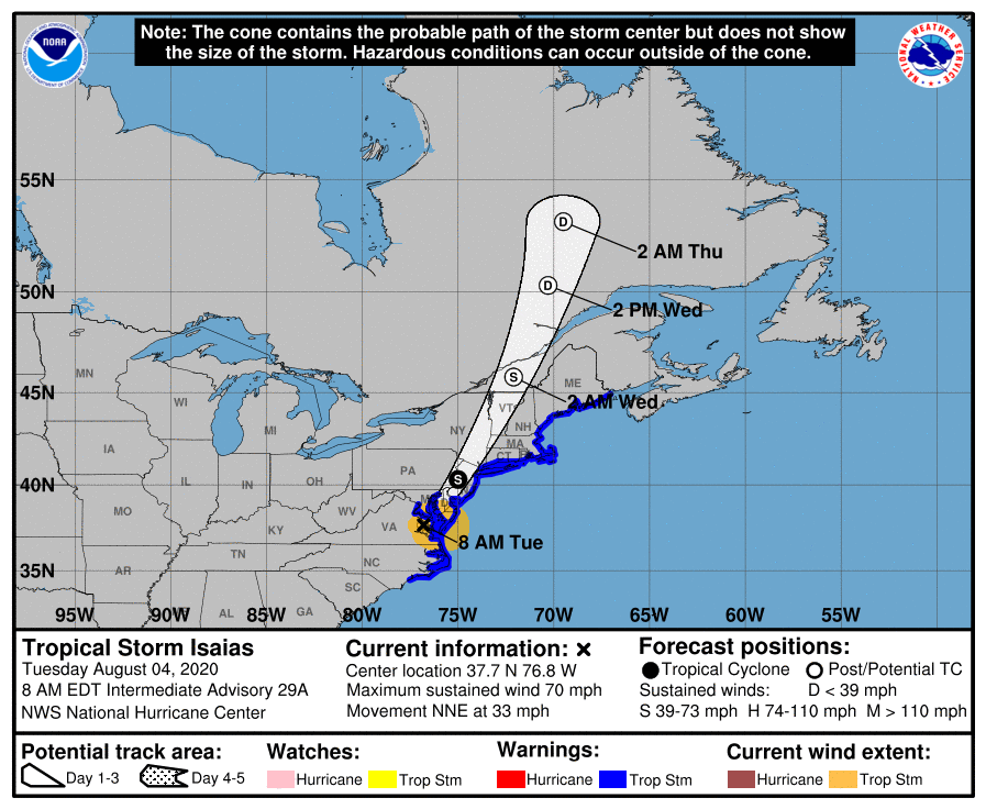
As of 09:00 UTC (05:00 LT) on Tuesday, Isaias weakened into a tropical storm, packing maximum sustained winds of 113 km/h (70 mph) with its center located near southeast Virginia.
All warnings have been discontinued for the coast of North Carolina south of Surf City. The Storm Surge Watch south of Surf City has also been discontinued.
A Storm Surge Warning is in effect for:
– Pamlico and Albemarle Sounds, including the Neuse and Pamlico Rivers
– Ocracoke Inlet North Carolina to the North Carolina/Virginia border
A Storm Surge Watch is in effect for:
– Surf City to Ocracoke Inlet North Carolina
A Tropical Storm Warning is in effect for
– North of Surf City North Carolina to Eastport Maine
– Pamlico and Albemarle Sounds
– The Chesapeake Bay
– Tidal Potomac River
– Delaware Bay
– Long Island and Long Island Sound
– Martha's Vineyard, Nantucket, and Block Island
"The cyclone is forecast to continue accelerating north-northeastward today as it is embedded in the strong south-southwesterly flow ahead of a deep-layer trough over the Great Lakes region," the National Hurricane Center (NHC) reported.
In 24 hours, the post-tropical cyclone is forecast to decelerate before it is absorbed by the extratropical low.
"In addition to the storm surge and wind threats, Isaias is expected to produce heavy rainfall along and just west of the I-95 corridor today, and the Weather Prediction Center has placed a portion of this area is a high risk for life-threatening flash flooding."
According to Philip Klotzbach, a meteorologist at CSU specializing in Atlantic basin seasonal hurricane forecasts, Isaias made landfall in North Carolina just over nine days following Hanna in Texas.
This is the shortest time between hurricane landfalls in the continental U.S. since Cindy and Dennis in 2005. The record for the shortest time is 23 hours, between Treasure Coast and Cuba/Brownsville in 1933.
Isaias is the 12th hurricane to make landfall in North Carolina in August since 1851. NC is now in third place for most hurricanes in any U.S. state during August, breaking a tie with Louisiana.
Florida holds the most hurricane landfalls in August with 23, followed by Texas with 17.
It was also the first hurricane to make landfall in North Carolina in August since Irene in 2011.
#Isaias made landfall in NC just over 9 days after Hanna made landfall in TX. This is the shortest time between #hurricane landfalls in the continental US since Cindy and Dennis in 2005 (~4.5 days). Record shortest time is 23 hours between Treasure Coast & Cuba/Brownsville (1933) pic.twitter.com/ZpRSijKckx
— Philip Klotzbach (@philklotzbach) August 4, 2020
#Isaias is the 12th #hurricane to make landfall in North Carolina in August on record (since 1851). North Carolina is now in 3rd place for most hurricanes in any US state during August, breaking a tie with Louisiana. Florida has most August landfalls (23), followed by Texas (17) pic.twitter.com/RA2Mn7IbIp
— Philip Klotzbach (@philklotzbach) August 4, 2020
The 2020 Atlantic #hurricane season is the 8th season on record (since 1851) with >=2 landfalling continental US hurricanes by August 3. Amazingly enough, in 1886, the continental US had already been hit by 4 hurricanes by July 19. #Isaias pic.twitter.com/YRmxhox4XQ
— Philip Klotzbach (@philklotzbach) August 4, 2020
The 2020 Atlantic #hurricane season has already generated 22.0 ACE (Accumulated Cyclone Energy) thru August 3. Only four seasons in the satellite era (since 1966) have generated more ACE through August 3: 1966 (33 ACE), 1996 (22.2 ACE), 2005 (64 ACE) and 2008 (38 ACE). #Isaias pic.twitter.com/ty06BDThJn
— Philip Klotzbach (@philklotzbach) August 4, 2020
NHC key messages
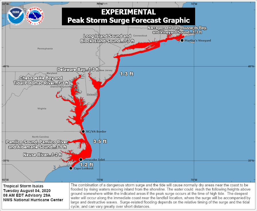
There is the danger of life-threatening storm surge inundation along portions of the immediate coastline and adjacent waterways of the North Carolina coast, including portions of Pamlico and Albemarle Sounds. Residents in these areas should follow the advice given by local emergency officials.
Isaias is expected to bring widespread sustained tropical storm force winds and wind gusts to hurricane force to the mid-Atlantic coast, including portions of the Chesapeake Bay region, through this afternoon, which could cause tree damage and power outages. Tropical storm conditions are expected to spread across New England tonight.
Heavy rainfall along the East Coast, near the path of Isaias, will result in flash flooding, some of which may be significant in North Carolina through the Mid-Atlantic and Northeast through tonight. Potentially life-threatening urban flooding is possible in D.C., Baltimore, and elsewhere along and just west of the I-95 corridor today. Widespread minor to moderate river flooding is likely across portions of the Carolinas and the Mid-Atlantic. Quick-responding rivers in the Northeast will also be susceptible to minor river flooding.
Tornadoes have already occurred over portions of northeastern North Carolina and southeastern Virginia overnight. The threat of tornadoes will spread northward along the mid-Atlantic coast today and then across New England by tonight.
Commenting rules and guidelines
We value the thoughts and opinions of our readers and welcome healthy discussions on our website. In order to maintain a respectful and positive community, we ask that all commenters follow these rules.