
Tasman low brings disruptive snowfall to Snowy Mountains and high waves to NSW coastline
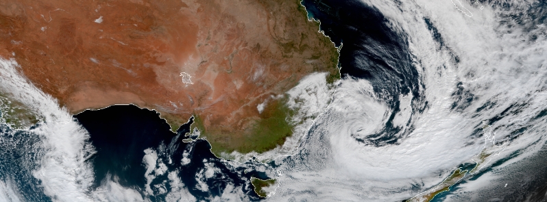
Image credit: JMA/Himawari-8, RAMMB/CIRA. Acquired 03:00 UTC on July 14, 2020.
A large Tasman low brought wet and windy conditions to New South Wales, Australia, beginning July 12, 2020. Heavy snow was reported in the Snowy Mountains, resulting in car accidents and widespread power outages. Strong winds and huge waves of up to 11.6 m (38 feet) hit the South Coast, generating a large waterspout over the sea. Hazardous conditions are forecast to continue throughout the week.
The first snowfall in the Snowy Mountains came through Sunday, leaving more than 40 cm (16 inches) of powder in the mountains by Monday morning.
Around Monday afternoon, the Kosciuszko Road was closed westbound and the Guthega Road was shut due to fallen trees and heavy snow. Widespread power outages were reported in areas including Crackenback, Moonbah, and Grosses Plain.
There was also a multi-vehicle crash on Kosciuszko, bringing traffic to a standstill. Motorists said it lasted for more than 30 minutes as emergency services cleared the scene.
Several car accidents occurred as well on Alpine Way as a number of trees were downed.
EAST JINDABYNE: Heavy traffic on Kosciuszko Rd due to multi-vehicle. Exercise caution, allow plenty of extra travel time and follow directions of traffic crews in the area. pic.twitter.com/EPMyNMSRM1
— Live Traffic NSW (@LiveTrafficNSW) July 13, 2020
More snow emus! #Kosciuszko #wildlife #Australia pic.twitter.com/q3DqacPMtp
— Chris Fust (@ChrisEFust) July 13, 2020
The NSW SES Snowy River unit responded to six calls around Cooma and Jindabyne, mostly about fallen trees and vehicle-related incidents.
"Road conditions are treacherous out there with ice, snow, and rain," the unit said. "If you are heading up to the ski fields please expect delays and take things extra slow."
"Even experienced alpine drivers in well fitted out vehicles have reported they are sliding off the road this morning."
Perisher, Thredbo, and Charlotte Pass recorded 35 cm (14 inches) of snow overnight.
The snow kept falling into Tuesday, dumping up to 1 m (3 feet) in a 24-hour period– the higher totals falling above 1 800 m (5 906 feet).
"The result is 100 percent of the terrain in the NSW resorts now has a good base and more lifts will open this week," Mountain Watch wrote.
#Emu in the snow! #Kosciuszko pic.twitter.com/eYkoSa6xs7
— Chris Fust (@ChrisEFust) July 13, 2020
Meanwhile, a tornado was spotted over the sea on Tuesday as the low hit the NSW coastline. A fisherman near Stanwell Tops, about 57 km (25 miles) south of Sydney, captured the phenomenon.
Along with heavy rains, waves up to 10 m (33 feet) high lashed the beaches across Sydney, peaking at 11.6 m (38 feet) overnight.
According to the Bureau of Meteorology (BOM), these big waves are expected to extend along much of the NWS coast and offshore southeast Queensland on Wednesday, July 15.
BOM warned that hazardous conditions will continue throughout the week, even once the Tasman low moves away, and the rain and wind begin to settle.
As this video from near Terrigal shows, today is not the day to be rock fishing, boating or swimming along the #NSW coast.
The peak wave height off #Sydney overnight was 11.6 metres.
Coastal forecast: https://t.co/AUxyWa3XtH
Hazardous Surf Warning: https://t.co/mkjgXGziob pic.twitter.com/D4umszhGDu— Bureau of Meteorology, New South Wales (@BOM_NSW) July 14, 2020
Commenting rules and guidelines
We value the thoughts and opinions of our readers and welcome healthy discussions on our website. In order to maintain a respectful and positive community, we ask that all commenters follow these rules.