
Eyes in the Sky: How satellites drastically improved hurricane forecasting
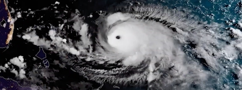
Image credit: NASA
Satellite technology has drastically changed how we forecast hurricanes as it has allowed us to track the storm's location, movement, and intensity, from formation to dissipation.
On September 8, 1900, a powerful hurricane hit Galveston, Texas, which resulted in about 8 000 fatalities and more than 3 600 buildings destroyed.
NASA published a video looking at the advances in hurricane forecasting 120 years since the disaster, focusing on the contributions from weather satellites.
"One of the dramatic impacts is that satellite data keeps an eye on the target," especially over unpopulated areas such as oceans, said JPSS Director Greg Mandt.
"We’re sort of like your eyes in the sky to make sure that Mother Nature can never surprise you," he added.
Earth-observing satellites, including those from the Joint Polar Satellite System (JPSS) and Geostationary Operational Environmental Satellite series (GOES-R), offers remarkable advances in hurricane forecasting.
The JPSS polar-orbiting satellites calculate the state of the atmosphere by taking accurate measurements of sea surface temperatures, as well as atmospheric temperature and moisture, which are important in securing storm forecasts several days in advance.
This video looks at advances in hurricane forecasting, with a focus on the contributions from weather satellites. Credit: NASA, Jefferson Beck
Mandt also said that improved sensors give us a better understanding of the core of hurricanes, and allow meteorologists to forecast where they are going to strike, without over-warning.
"Then you can narrow and shrink that cone of uncertainty and give a better prediction."
The GOES satellites orbit at the same rate as the Earth rotates, allowing them to have a look at hurricanes as they evolve. This, combined with advances to the sensors, provides us with a view of hurricanes in motion.
"We take a full-disc picture of the entire hemisphere in five minutes," said GOES-R Series System Program Director Pam Sullivan.
"But we can also look at a smaller area and scan it every 30 seconds. You get to see the hurricane eyewall forming," he continued.
"You can see it actually forming in real-time. The Earth looks alive. It looks like a living thing."
Commenting rules and guidelines
We value the thoughts and opinions of our readers and welcome healthy discussions on our website. In order to maintain a respectful and positive community, we ask that all commenters follow these rules.